Property Record
236 W North Bend Rd, Cincinnati, OH 45216
NEARBY LISTINGS FOR SALE OR LEASE
Property Detail
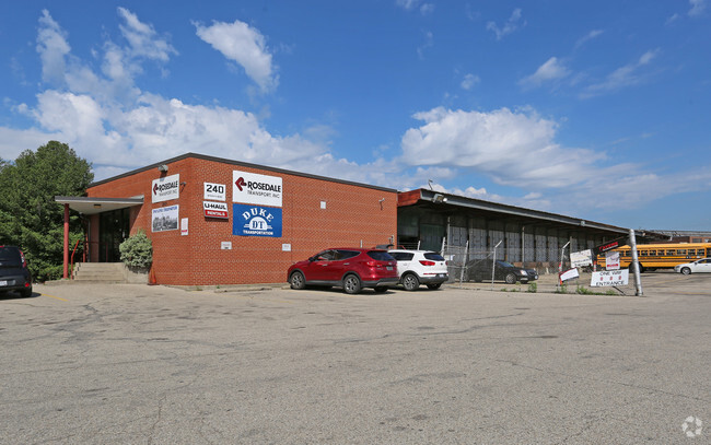
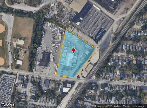
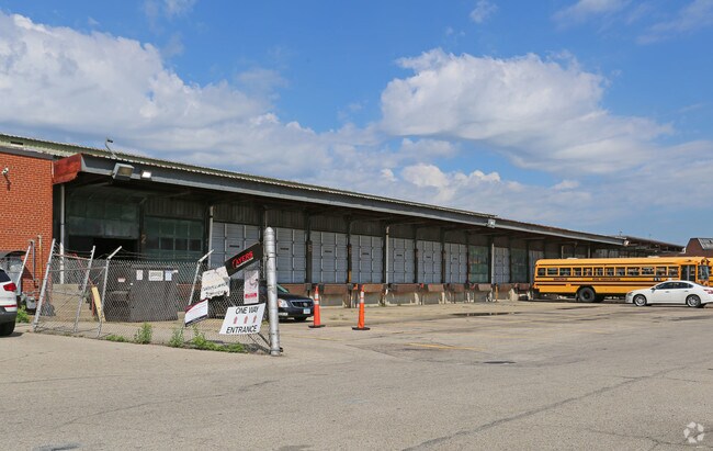
236 W North Bend Rd
242-0004-0006
NORTH BEND RD 4.02 AC - R1-T3-S7
Truckterminal
Hamilton
X
Ohio
39061C0228E
4.03 AC
2024
Central/Midtown
2024
Cincinnati/Dayton
006100
Cincinnati, OH-KY-IN
25,592 SF
DEMOGRAPHICS near 236 W North Bend Rd
1 Mile
3 Mile
5 Mile
2024 Total Population
6,338
90,456
269,728
2029 Population
6,235
89,233
267,881
Pop Growth 2024-2029
(1.63%)
(1.35%)
(0.68%)
Average Age
39
40
39
2024 Total Households
2,593
38,573
118,614
HH Growth 2024-2029
(1.70%)
(1.41%)
(0.83%)
Median Household Inc
$38,967
$56,082
$55,193
Avg Household Size
2.30
2.20
2.10
2024 Avg HH Vehicles
2.00
2.00
2.00
Median Home Value
$86,390
$166,239
$181,028
Median Year Built
1947
1952
1953
Nearby Places
Map Layers
Map Styles
 Street
 Aerial
- Restaurants
- Banks
- Shops
- Fitness
- Groceries
PUBLIC TRANSPORTATION
COMMUTER RAIL
Cincinnati Union Terminal (Cardinal - Amtrak)
DRIVE
WALK
Distance
Cincinnati Union Terminal (Cardinal - Amtrak)
14 min
8.9 mi
AIRPORT
Cincinnati/Northern Kentucky International
DRIVE
WALK
Distance
Cincinnati/Northern Kentucky International
38 min
22.9 mi
Freight Ports
Port of Toledo
DRIVE
WALK
Distance
Port of Toledo
230 min
197.8 mi
SALE & LEASE HISTORY
LISTING DATE
SALE/LEASE

Sep 24, 2018
For Lease
Nearby Properties
Address
Land Use
TOTAL SIZE
Lot Size
Zoning
Address
Land Use
TOTAL SIZE
Lot Size
Zoning
21.34 AC
Address
Land Use
TOTAL SIZE
Lot Size
Zoning
2.49 AC
DD
Address
Land Use
TOTAL SIZE
Lot Size
Zoning
6.34 AC
Address
Land Use
TOTAL SIZE
Lot Size
Zoning
29.67 AC
RM20
Address
Land Use
TOTAL SIZE
Lot Size
Zoning
11,639 SF
7.87 AC
R2
Address
Land Use
TOTAL SIZE
Lot Size
Zoning
14.15 AC
Address
Land Use
TOTAL SIZE
Lot Size
Zoning
23.45 AC
Address
Land Use
TOTAL SIZE
Lot Size
Zoning
330,335 SF
0.80 AC
R3
Address
Land Use
TOTAL SIZE
Lot Size
Zoning
42.41 AC
Address
Land Use
TOTAL SIZE
Lot Size
Zoning
344,923 SF
18.47 AC
RM20
Address
Land Use
TOTAL SIZE
Lot Size
Zoning
Address
Land Use
TOTAL SIZE
Lot Size
Zoning
13.08 AC
Address
Land Use
TOTAL SIZE
Lot Size
Zoning
210,743 SF
0.35 AC
DD
Address
Land Use
TOTAL SIZE
Lot Size
Zoning
20.07 AC
B2
Address
Land Use
TOTAL SIZE
Lot Size
Zoning
2.22 AC
Address
Land Use
TOTAL SIZE
Lot Size
Zoning
4.14 AC
M2PUD
Address
Land Use
TOTAL SIZE
Lot Size
Zoning
437,072 SF
8.03 AC
R2
Address
Land Use
TOTAL SIZE
Lot Size
Zoning
Address
Land Use
TOTAL SIZE
Lot Size
Zoning
88.15 AC
ML
Address
Land Use
TOTAL SIZE
Lot Size
Zoning
11,664 SF
29.27 AC
RM20
Address
Land Use
TOTAL SIZE
Lot Size
Zoning
Address
Land Use
TOTAL SIZE
Lot Size
Zoning
17,758 SF
7 AC
RM20
Address
Land Use
TOTAL SIZE
Lot Size
Zoning
8,720 SF
33.28 AC
R3
Address
Land Use
TOTAL SIZE
Lot Size
Zoning
Address
Land Use
TOTAL SIZE
Lot Size
Zoning
121,747 SF
23.05 AC
R3
Address
Land Use
TOTAL SIZE
Lot Size
Zoning
4.06 AC
M2PUD
Address
Land Use
TOTAL SIZE
Lot Size
Zoning
9.51 AC
Address
Land Use
TOTAL SIZE
Lot Size
Zoning
38,680 SF
7.07 AC
RM20
Address
Land Use
TOTAL SIZE
Lot Size
Zoning
25.26 AC
Address
Land Use
TOTAL SIZE
Lot Size
Zoning
9.74 AC
PD
The World's #1 Commercial Real Estate Marketplace
Connect with us
© 2025 CoStar Group
The information above has been obtained from sources believed reliable. While we do not doubt its accuracy we have not verified it and make no guarantee, warranty or representation about it. It is your responsibility to independently confirm its accuracy and completeness. Any projections, opinions, assumptions, or estimates used are for example only and do not represent the current or future performance of the property. The value of this transaction to you depends on tax and other factors which should be evaluated by your tax, financial, and legal advisors. You and your advisors should conduct a careful, independent investigation of the property to determine to your satisfaction the suitability of the property for your needs.