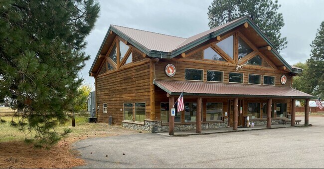
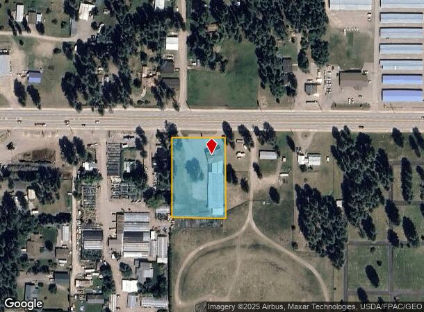
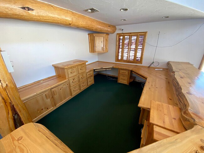
Property Record
2400 9Th St W, Columbia Falls, MT 59912

NEARBY LISTINGS FOR SALE OR LEASE
-
-
-
No Photo
-
-
-
View all Columbia Falls listings for sale on LoopNet.com
Property Detail
2400 9Th St W
07-4186-18-2-01-60-0000
S18, T30 N, R20 W, TR 9B IN L 1
Storebuilding
Flathead
X
Montana
30029C1430J
1.47 AC
2025
Glacier Country
2025
Other Market Areas
000201
Kalispell, MT
11,436 SF
DEMOGRAPHICS near 2400 9Th St W
1 Mile
3 Mile
5 Mile
2024 Total Population
2,929
10,780
15,625
2029 Population
3,402
12,472
18,125
Pop Growth 2024-2029
+ 16.15%
+ 15.70%
+ 16.00%
Average Age
40
41
42
2024 Total Households
1,101
4,297
6,244
HH Growth 2024-2029
+ 15.89%
+ 15.52%
+ 15.89%
Median Household Inc
$66,731
$65,371
$69,359
Avg Household Size
2.60
2.40
2.40
2024 Avg HH Vehicles
2.00
2.00
2.00
Median Home Value
$348,518
$368,188
$426,080
Median Year Built
1993
1985
1989
Nearby Places
Map Layers
Map Styles
 Street
 Aerial
- Restaurants
- Banks
- Shops
- Fitness
- Groceries
PUBLIC TRANSPORTATION
COMMUTER RAIL
Whitefish Amtrak Station (Empire Builder - Amtrak)
DRIVE
WALK
Distance
Whitefish Amtrak Station (Empire Builder - Amtrak)
10 min
8.4 mi
AIRPORT
Glacier Park International
DRIVE
WALK
Distance
Glacier Park International
10 min
6.3 mi
Freight Ports
Port of Everett
DRIVE
WALK
Distance
Port of Everett
648 min
559.2 mi
SALE & LEASE HISTORY
LISTING DATE
SALE/LEASE

Oct 25, 2022
For Sale
Nearby Properties
Address
Land Use
TOTAL SIZE
Lot Size
Zoning
Address
Land Use
TOTAL SIZE
Lot Size
Zoning
74,223 SF
11.96 AC
Address
Land Use
TOTAL SIZE
Lot Size
Zoning
48,844 SF
2.55 AC
1
Address
Land Use
TOTAL SIZE
Lot Size
Zoning
58,212 SF
0.74 AC
Address
Land Use
TOTAL SIZE
Lot Size
Zoning
135,000 SF
154.30 AC
7
Address
Land Use
TOTAL SIZE
Lot Size
Zoning
50,727 SF
149 AC
1
Address
Land Use
TOTAL SIZE
Lot Size
Zoning
22,887 SF
25.46 AC
7
Address
Land Use
TOTAL SIZE
Lot Size
Zoning
67,200 SF
10.01 AC
Address
Land Use
TOTAL SIZE
Lot Size
Zoning
1,612 SF
10.87 AC
Address
Land Use
TOTAL SIZE
Lot Size
Zoning
17,100 SF
4.41 AC
Address
Land Use
TOTAL SIZE
Lot Size
Zoning
53,854 SF
5.59 AC
Address
Land Use
TOTAL SIZE
Lot Size
Zoning
6,000 SF
10.07 AC
Address
Land Use
TOTAL SIZE
Lot Size
Zoning
38,512 SF
7.59 AC
5
Address
Land Use
TOTAL SIZE
Lot Size
Zoning
28,544 SF
5.25 AC
7
Address
Land Use
TOTAL SIZE
Lot Size
Zoning
45,120 SF
5.69 AC
Address
Land Use
TOTAL SIZE
Lot Size
Zoning
29,724 SF
15.51 AC
Address
Land Use
TOTAL SIZE
Lot Size
Zoning
5,492 SF
2.20 AC
Address
Land Use
TOTAL SIZE
Lot Size
Zoning
18,900 SF
7.56 AC
Address
Land Use
TOTAL SIZE
Lot Size
Zoning
2,726 SF
39.67 AC
Address
Land Use
TOTAL SIZE
Lot Size
Zoning
44,739 SF
1.52 AC
1
Address
Land Use
TOTAL SIZE
Lot Size
Zoning
27,337 SF
6.71 AC
6
Address
Land Use
TOTAL SIZE
Lot Size
Zoning
6,560 SF
14.19 AC
Address
Land Use
TOTAL SIZE
Lot Size
Zoning
2,952 SF
3.87 AC
Address
Land Use
TOTAL SIZE
Lot Size
Zoning
10,350 SF
5 AC
Address
Land Use
TOTAL SIZE
Lot Size
Zoning
10,012 SF
12 AC
Address
Land Use
TOTAL SIZE
Lot Size
Zoning
72,000 SF
10.01 AC
Address
Land Use
TOTAL SIZE
Lot Size
Zoning
24,693 SF
0.92 AC
Address
Land Use
TOTAL SIZE
Lot Size
Zoning
53,130 SF
2.26 AC
Address
Land Use
TOTAL SIZE
Lot Size
Zoning
12,480 SF
4.61 AC
Address
Land Use
TOTAL SIZE
Lot Size
Zoning
18,100 SF
2.28 AC
Address
Land Use
TOTAL SIZE
Lot Size
Zoning
480 SF
8.93 AC
The World's #1 Commercial Real Estate Marketplace
Connect with us
© 2025 CoStar Group
The information above has been obtained from sources believed reliable. While we do not doubt its accuracy we have not verified it and make no guarantee, warranty or representation about it. It is your responsibility to independently confirm its accuracy and completeness. Any projections, opinions, assumptions, or estimates used are for example only and do not represent the current or future performance of the property. The value of this transaction to you depends on tax and other factors which should be evaluated by your tax, financial, and legal advisors. You and your advisors should conduct a careful, independent investigation of the property to determine to your satisfaction the suitability of the property for your needs.