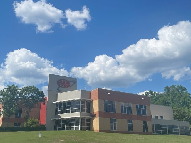
Property Record
2400 Acton Rd, Vestavia, AL 35243


Current Lease Availabilities
NEARBY LISTINGS FOR SALE OR LEASE
Property Detail
2400 Acton Rd
40-00-05-1-000-043.000
COM INTER OF NE COR ACTON RD & ROCKY RIDGE RD TH NW 20.3 FT TH CONT NW 131.3 FT TH NE 114.8 FT TH CONT NELY 109.5 FT TH NE 50.5 FT TH NELY 326.3 FT TH S 320 FT TH E 220 FT TH SE 115 FT TH SW 40 FT TH SWLY 106.7 FT TH SW 250.9 FT TH SWLY 109.2 FT TO P
Governmentalpublicusegeneral
Jefferson
X
Alabama
01117C0067F
2.82 AC
2023
Hwy 280/Jefferson County
2024
Birmingham
012911
Birmingham-Hoover, AL
25,239 SF
DEMOGRAPHICS near 2400 Acton Rd
1 Mile
3 Mile
5 Mile
2024 Total Population
4,133
55,264
141,624
2029 Population
3,982
54,740
141,610
Pop Growth 2024-2029
(3.65%)
(0.95%)
(0.01%)
Average Age
41
39
39
2024 Total Households
1,678
23,517
58,398
HH Growth 2024-2029
(4.17%)
(1.12%)
(0.11%)
Median Household Inc
$88,531
$83,285
$90,041
Avg Household Size
2.40
2.30
2.30
2024 Avg HH Vehicles
2.00
2.00
2.00
Median Home Value
$358,431
$360,488
$369,148
Median Year Built
1984
1983
1983
Nearby Places
Map Layers
Map Styles
 Street
 Aerial
- Restaurants
- Banks
- Shops
- Fitness
- Groceries
PUBLIC TRANSPORTATION
AIRPORT
Birmingham-Shuttlesworth International
DRIVE
WALK
Distance
Birmingham-Shuttlesworth International
23 min
13.8 mi
Freight Ports
Port of Mobile
DRIVE
WALK
Distance
Port of Mobile
270 min
247.9 mi
Nearby Properties
Address
Land Use
TOTAL SIZE
Lot Size
Zoning
Address
Land Use
TOTAL SIZE
Lot Size
Zoning
1,008,008 SF
73.91 AC
R4
Address
Land Use
TOTAL SIZE
Lot Size
Zoning
212,615 SF
19.66 AC
B-2
Address
Land Use
TOTAL SIZE
Lot Size
Zoning
140,853 SF
27 AC
B-2
Address
Land Use
TOTAL SIZE
Lot Size
Zoning
7,280 SF
35 AC
Address
Land Use
TOTAL SIZE
Lot Size
Zoning
347,636 SF
136.83 AC
Address
Land Use
TOTAL SIZE
Lot Size
Zoning
169,501 SF
18 AC
E-2
Address
Land Use
TOTAL SIZE
Lot Size
Zoning
235,082 SF
26.10 AC
C1
Address
Land Use
TOTAL SIZE
Lot Size
Zoning
102,373 SF
12.33 AC
R1-E
Address
Land Use
TOTAL SIZE
Lot Size
Zoning
344,434 SF
15.52 AC
R4
Address
Land Use
TOTAL SIZE
Lot Size
Zoning
365,402 SF
25 AC
R4
Address
Land Use
TOTAL SIZE
Lot Size
Zoning
125,165 SF
8.07 AC
CP
Address
Land Use
TOTAL SIZE
Lot Size
Zoning
294,855 SF
30 AC
R4
Address
Land Use
TOTAL SIZE
Lot Size
Zoning
446,170 SF
18.93 AC
PR2
Address
Land Use
TOTAL SIZE
Lot Size
Zoning
121,872 SF
8.70 AC
PB
Address
Land Use
TOTAL SIZE
Lot Size
Zoning
170,850 SF
9.31 AC
INST
Address
Land Use
TOTAL SIZE
Lot Size
Zoning
252,432 SF
17.99 AC
R5
Address
Land Use
TOTAL SIZE
Lot Size
Zoning
219,277 SF
22.50 AC
R5
Address
Land Use
TOTAL SIZE
Lot Size
Zoning
94,126 SF
10 AC
C-1
Address
Land Use
TOTAL SIZE
Lot Size
Zoning
218,354 SF
15.23 AC
R4
Address
Land Use
TOTAL SIZE
Lot Size
Zoning
195,150 SF
11 AC
R-5
Address
Land Use
TOTAL SIZE
Lot Size
Zoning
191,623 SF
19.93 AC
R4
Address
Land Use
TOTAL SIZE
Lot Size
Zoning
102,342 SF
11 AC
Address
Land Use
TOTAL SIZE
Lot Size
Zoning
76,816 SF
4.90 AC
PO
Address
Land Use
TOTAL SIZE
Lot Size
Zoning
221,936 SF
14.18 AC
R4
Address
Land Use
TOTAL SIZE
Lot Size
Zoning
306,182 SF
15.37 AC
R4
Address
Land Use
TOTAL SIZE
Lot Size
Zoning
277,473 SF
7 AC
R4
Address
Land Use
TOTAL SIZE
Lot Size
Zoning
54,541 SF
4.71 AC
PO
Address
Land Use
TOTAL SIZE
Lot Size
Zoning
134,434 SF
10.14 AC
Address
Land Use
TOTAL SIZE
Lot Size
Zoning
153,682 SF
20.07 AC
R4
Address
Land Use
TOTAL SIZE
Lot Size
Zoning
72,975 SF
4.28 AC
B-2
The World's #1 Commercial Real Estate Marketplace
Connect with us
© 2025 CoStar Group
The information above has been obtained from sources believed reliable. While we do not doubt its accuracy we have not verified it and make no guarantee, warranty or representation about it. It is your responsibility to independently confirm its accuracy and completeness. Any projections, opinions, assumptions, or estimates used are for example only and do not represent the current or future performance of the property. The value of this transaction to you depends on tax and other factors which should be evaluated by your tax, financial, and legal advisors. You and your advisors should conduct a careful, independent investigation of the property to determine to your satisfaction the suitability of the property for your needs.