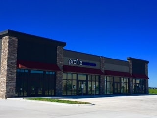
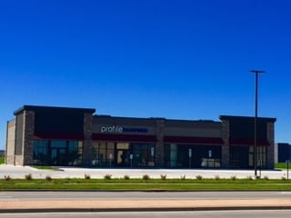
Property Record
2400 Bluestem Dr E, West Fargo, ND 58078
NEARBY LISTINGS FOR SALE OR LEASE
Property Detail
2400 Bluestem Dr E
Fargo, ND-MN
Orth
02-4608-00090-000
LOT: 1 BLOCK: 3 ADDITION: NORTH POND AT THE PRESERVE 9TH ADDITION ADDITIONAL: NORTH POND AT THE PRESERVE 9TH LT 1 BLK 3 **7-19-16 REPLATTED FRM 02-4602-00060-000 & 02-4602-00070-000 PER PLAT DOC# 1477615
Commercialacreage
Cass
X
North Dakota
38017C0759G
1
2024
7.45 AC
2024
Fargo
010205
Other Market Areas
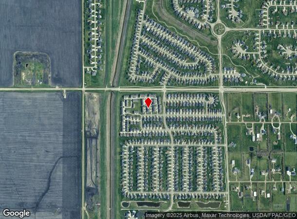
DEMOGRAPHICS near 2400 Bluestem Dr E
1 Mile
3 Mile
5 Mile
2024 Total Population
12,515
86,783
145,545
2029 Population
13,447
93,256
156,069
Pop Growth 2024-2029
+ 7.45%
+ 7.46%
+ 7.23%
Average Age
33
35
36
2024 Total Households
5,481
37,566
62,164
HH Growth 2024-2029
+ 8.08%
+ 7.91%
+ 7.75%
Median Household Inc
$77,777
$69,854
$67,936
Avg Household Size
2.20
2.30
2.20
2024 Avg HH Vehicles
2.00
2.00
2.00
Median Home Value
$373,683
$271,992
$260,885
Median Year Built
2010
2003
1998
Nearby Places
Map Layers
Map Styles
 Street
 Aerial
- Restaurants
- Banks
- Shops
- Fitness
- Groceries
PUBLIC TRANSPORTATION
AIRPORT
Hector International
DRIVE
WALK
Distance
Hector International
25 min
13.8 mi
Freight Ports
Port Milwaukee
DRIVE
WALK
Distance
Port Milwaukee
638 min
579.3 mi
SALE & LEASE HISTORY
LISTING DATE
SALE/LEASE

Sep 25, 2016
For Lease
Oct 20, 2016
For Lease
Nearby Properties
Address
Land Use
TOTAL SIZE
Lot Size
Zoning
Address
Land Use
TOTAL SIZE
Lot Size
Zoning
Address
Land Use
TOTAL SIZE
Lot Size
Zoning
418,024 SF
10.88 AC
Address
Land Use
TOTAL SIZE
Lot Size
Zoning
Address
Land Use
TOTAL SIZE
Lot Size
Zoning
7.66 AC
Address
Land Use
TOTAL SIZE
Lot Size
Zoning
Address
Land Use
TOTAL SIZE
Lot Size
Zoning
Address
Land Use
TOTAL SIZE
Lot Size
Zoning
34,100 SF
1.46 AC
MR3
Address
Land Use
TOTAL SIZE
Lot Size
Zoning
Address
Land Use
TOTAL SIZE
Lot Size
Zoning
9,279 SF
8.33 AC
MR1
Address
Land Use
TOTAL SIZE
Lot Size
Zoning
48,300 SF
2.33 AC
MR3
Address
Land Use
TOTAL SIZE
Lot Size
Zoning
30,240 SF
1.54 AC
MR2
Address
Land Use
TOTAL SIZE
Lot Size
Zoning
Address
Land Use
TOTAL SIZE
Lot Size
Zoning
73,907 SF
3.41 AC
MR3
Address
Land Use
TOTAL SIZE
Lot Size
Zoning
152,509 SF
18.14 AC
Address
Land Use
TOTAL SIZE
Lot Size
Zoning
46,271 SF
2.06 AC
MR3
Address
Land Use
TOTAL SIZE
Lot Size
Zoning
152,918 SF
5.38 AC
Address
Land Use
TOTAL SIZE
Lot Size
Zoning
54,927 SF
8.45 AC
Address
Land Use
TOTAL SIZE
Lot Size
Zoning
41,046 SF
11.90 AC
Address
Land Use
TOTAL SIZE
Lot Size
Zoning
41,046 SF
11.78 AC
Address
Land Use
TOTAL SIZE
Lot Size
Zoning
794,266 SF
36.84 AC
GC
Address
Land Use
TOTAL SIZE
Lot Size
Zoning
113,388 SF
3.41 AC
MR3
Address
Land Use
TOTAL SIZE
Lot Size
Zoning
Address
Land Use
TOTAL SIZE
Lot Size
Zoning
7.18 AC
Address
Land Use
TOTAL SIZE
Lot Size
Zoning
116,751 SF
10.16 AC
Address
Land Use
TOTAL SIZE
Lot Size
Zoning
42,476 SF
2.07 AC
MR1
Address
Land Use
TOTAL SIZE
Lot Size
Zoning
7.56 AC
Address
Land Use
TOTAL SIZE
Lot Size
Zoning
24,780 SF
1.43 AC
MR3
Address
Land Use
TOTAL SIZE
Lot Size
Zoning
30,240 SF
8.93 AC
Address
Land Use
TOTAL SIZE
Lot Size
Zoning
2.20 AC
Address
Land Use
TOTAL SIZE
Lot Size
Zoning
3.21 AC
The World's #1 Commercial Real Estate Marketplace
Connect with us
© 2025 CoStar Group
The information above has been obtained from sources believed reliable. While we do not doubt its accuracy we have not verified it and make no guarantee, warranty or representation about it. It is your responsibility to independently confirm its accuracy and completeness. Any projections, opinions, assumptions, or estimates used are for example only and do not represent the current or future performance of the property. The value of this transaction to you depends on tax and other factors which should be evaluated by your tax, financial, and legal advisors. You and your advisors should conduct a careful, independent investigation of the property to determine to your satisfaction the suitability of the property for your needs.