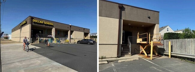
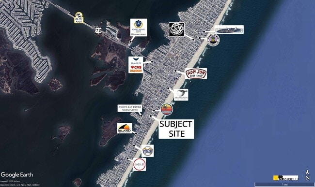
Property Record
2400 Boulevard, Beach Haven, NJ 08008

Property Detail
2400 Boulevard
29-00029-0000-00014
160X90 15,16
Commercialnec
OCEAN
SC
New Jersey
AE The base floodplain where base flood elevations are provided. AE Zones are now used on new format FIRMs instead of A1-A30 Zones.
14
2025
0.33 AC
2025
Ocean County
738001
Northern New Jersey
9,868 SF
Lakewood-New Brunswick, NJ
NEARBY LISTINGS FOR SALE OR LEASE
DEMOGRAPHICS near 2400 Boulevard
1 mile
3 mile
5 mile
2025 Total Population
3,564
16,494
27,721
2030 Population
4,165
19,201
32,070
Pop Growth 2025-2030
+ 16.86%
+ 16.41%
+ 15.69%
Average Age
52
52
52
2025 Total Households
1,711
7,719
12,910
HH Growth 2025-2030
+ 16.60%
+ 16.19%
+ 15.53%
Median Household Inc
$120,197
$121,959
$117,502
Avg Household Size
2.00
2.00
2.10
2025 Avg HH Vehicles
2.00
2.00
2.00
Median Home Value
$847,222
$820,031
$789,007
Median Year Built
1972
1980
1981
Nearby Places
Map Layers
Map Styles
 Street
 Aerial
Transit
 Traffic
 Biking
Places
Listings with unknown addresses are not visible on the map
- Restaurants
- Banks
- Shops
- Fitness
- Groceries
PUBLIC TRANSPORTATION
AIRPORT
Atlantic City International
Drive
Walk
Distance
Atlantic City International
69 min
37.8 mi
Freight Ports
Broadway Terminal - Pier 5
Drive
Walk
Distance
Broadway Terminal - Pier 5
80 min
60.1 mi
SALE & LEASE HISTORY
LISTING DATE
SALE/LEASE

Jul 17, 2025
For Lease
Nearby Properties
Address
Land Use
TOTAL SIZE
Lot Size
Zoning
Address
Land Use
TOTAL SIZE
Lot Size
Zoning
18,880 SF
1.93 AC
GC
Address
Land Use
TOTAL SIZE
Lot Size
Zoning
5.62 AC
R50
Address
Land Use
TOTAL SIZE
Lot Size
Zoning
10,292 SF
1.28 AC
P
Address
Land Use
TOTAL SIZE
Lot Size
Zoning
17,884 SF
0.48 AC
P
Address
Land Use
TOTAL SIZE
Lot Size
Zoning
34,500 SF
2.53 AC
RA
Address
Land Use
TOTAL SIZE
Lot Size
Zoning
6,776 SF
3.96 AC
P
Address
Land Use
TOTAL SIZE
Lot Size
Zoning
27,365 SF
2.25 AC
R50
Address
Land Use
TOTAL SIZE
Lot Size
Zoning
Address
Land Use
TOTAL SIZE
Lot Size
Zoning
14,440 SF
0.83 AC
MFR
Address
Land Use
TOTAL SIZE
Lot Size
Zoning
0.94 AC
R50
Address
Land Use
TOTAL SIZE
Lot Size
Zoning
2,892 SF
1.85 AC
RA
Address
Land Use
TOTAL SIZE
Lot Size
Zoning
5,904 SF
1.29 AC
B
Address
Land Use
TOTAL SIZE
Lot Size
Zoning
6,101 SF
0.92 AC
RA
Address
Land Use
TOTAL SIZE
Lot Size
Zoning
3,444 SF
0.86 AC
R50
Address
Land Use
TOTAL SIZE
Lot Size
Zoning
Address
Land Use
TOTAL SIZE
Lot Size
Zoning
1.93 AC
RA
Address
Land Use
TOTAL SIZE
Lot Size
Zoning
14,906 SF
1.26 AC
MC
Address
Land Use
TOTAL SIZE
Lot Size
Zoning
20,544 SF
5.56 AC
MC
Address
Land Use
TOTAL SIZE
Lot Size
Zoning
0.49 AC
RA
Address
Land Use
TOTAL SIZE
Lot Size
Zoning
2,990 SF
13.20 AC
MC
Address
Land Use
TOTAL SIZE
Lot Size
Zoning
9,094 SF
0.83 AC
B
Address
Land Use
TOTAL SIZE
Lot Size
Zoning
392 SF
0.31 AC
RA
Address
Land Use
TOTAL SIZE
Lot Size
Zoning
1,824 SF
0.39 AC
RA
Address
Land Use
TOTAL SIZE
Lot Size
Zoning
21,873 SF
0.41 AC
B
Address
Land Use
TOTAL SIZE
Lot Size
Zoning
2,406 SF
0.92 AC
GCEC
Address
Land Use
TOTAL SIZE
Lot Size
Zoning
0.51 AC
GC
Address
Land Use
TOTAL SIZE
Lot Size
Zoning
7,646 SF
0.46 AC
RA
Address
Land Use
TOTAL SIZE
Lot Size
Zoning
1.03 AC
R10
Address
Land Use
TOTAL SIZE
Lot Size
Zoning
7,760 SF
0.83 AC
B
Address
Land Use
TOTAL SIZE
Lot Size
Zoning
5,180 SF
1.34 AC
P
The World's #1 Commercial Real Estate Marketplace
Connect with us
© 2026 CoStar Group
The information above has been obtained from sources believed reliable. While we do not doubt its accuracy we have not verified it and make no guarantee, warranty or representation about it. It is your responsibility to independently confirm its accuracy and completeness. Any projections, opinions, assumptions, or estimates used are for example only and do not represent the current or future performance of the property. The value of this transaction to you depends on tax and other factors which should be evaluated by your tax, financial, and legal advisors. You and your advisors should conduct a careful, independent investigation of the property to determine to your satisfaction the suitability of the property for your needs.