Property Record
2400 E Interstate 20, Arlington, TX 76018

Property Detail
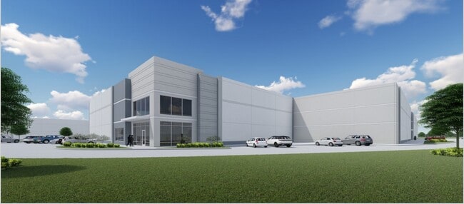
2400 E Interstate 20
Dallas-Fort Worth-Arlington, TX
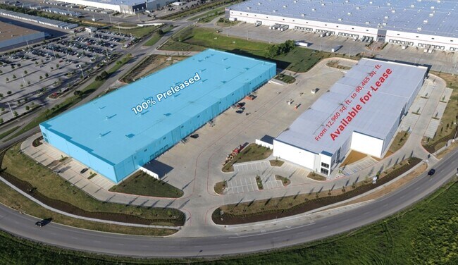
BARDIN CROSSING AT I-20 LOT 1
42793830
TARRANT
Commercialnec
Texas
2025
1
2025
6.65 AC
111513
Arlington
90,465 SF
Dallas/Ft Worth
NEARBY LISTINGS FOR SALE OR LEASE
DEMOGRAPHICS near 2400 E Interstate 20
1 mile
3 mile
5 mile
2025 Total Population
11,514
130,759
337,744
2030 Population
12,074
137,095
353,346
Pop Growth 2025-2030
+ 4.86%
+ 4.85%
+ 4.62%
Average Age
35
36
36
2025 Total Households
4,087
42,787
111,452
HH Growth 2025-2030
+ 5.11%
+ 4.92%
+ 4.77%
Median Household Inc
$73,631
$74,299
$72,141
Avg Household Size
2.80
3.00
2.90
2025 Avg HH Vehicles
2.00
2.00
2.00
Median Home Value
$271,967
$283,491
$288,589
Median Year Built
1992
1988
1987
Nearby Places
Map Layers
Map Styles
 Street
 Aerial
Transit
 Traffic
 Biking
Places
Listings with unknown addresses are not visible on the map
- Restaurants
- Banks
- Shops
- Fitness
- Groceries
PUBLIC TRANSPORTATION
AIRPORT
Dallas-Fort Worth International
Drive
Walk
Distance
Dallas-Fort Worth International
28 min
20.2 mi
Dallas Love Field
Drive
Walk
Distance
Dallas Love Field
36 min
26.4 mi
Freight Ports
Port of Shreveport
Drive
Walk
Distance
Port of Shreveport
228 min
212.1 mi
SALE & LEASE HISTORY
LISTING DATE
SALE/LEASE

Aug 05, 2021
For Lease
Nearby Properties
Address
Land Use
TOTAL SIZE
Lot Size
Zoning
Address
Land Use
TOTAL SIZE
Lot Size
Zoning
569,876 SF
47.80 AC
Address
Land Use
TOTAL SIZE
Lot Size
Zoning
804,384 SF
48.38 AC
Address
Land Use
TOTAL SIZE
Lot Size
Zoning
799,893 SF
19.43 AC
Address
Land Use
TOTAL SIZE
Lot Size
Zoning
529,992 SF
35.21 AC
Address
Land Use
TOTAL SIZE
Lot Size
Zoning
456,473 SF
32.79 AC
Address
Land Use
TOTAL SIZE
Lot Size
Zoning
1,114,563 SF
89.72 AC
Address
Land Use
TOTAL SIZE
Lot Size
Zoning
485,300 SF
16.51 AC
Z312
Address
Land Use
TOTAL SIZE
Lot Size
Zoning
428,147 SF
14.45 AC
Z313
Address
Land Use
TOTAL SIZE
Lot Size
Zoning
368,004 SF
13.89 AC
Address
Land Use
TOTAL SIZE
Lot Size
Zoning
453,257 SF
121.21 AC
Address
Land Use
TOTAL SIZE
Lot Size
Zoning
301,120 SF
14.23 AC
Z313
Address
Land Use
TOTAL SIZE
Lot Size
Zoning
266,460 SF
12 AC
Z313
Address
Land Use
TOTAL SIZE
Lot Size
Zoning
478,110 SF
11.74 AC
Z313
Address
Land Use
TOTAL SIZE
Lot Size
Zoning
206,650 SF
18.92 AC
Address
Land Use
TOTAL SIZE
Lot Size
Zoning
402,935 SF
20.72 AC
Address
Land Use
TOTAL SIZE
Lot Size
Zoning
375,213 SF
17.77 AC
Address
Land Use
TOTAL SIZE
Lot Size
Zoning
298,234 SF
23.39 AC
Address
Land Use
TOTAL SIZE
Lot Size
Zoning
280,000 SF
10.85 AC
Address
Land Use
TOTAL SIZE
Lot Size
Zoning
821,502 SF
45.37 AC
Address
Land Use
TOTAL SIZE
Lot Size
Zoning
352,999 SF
60.81 AC
Address
Land Use
TOTAL SIZE
Lot Size
Zoning
315,359 SF
15 AC
Address
Land Use
TOTAL SIZE
Lot Size
Zoning
229,000 SF
8.01 AC
Address
Land Use
TOTAL SIZE
Lot Size
Zoning
387,500 SF
13.54 AC
Z313
Address
Land Use
TOTAL SIZE
Lot Size
Zoning
302,022 SF
15.37 AC
Address
Land Use
TOTAL SIZE
Lot Size
Zoning
252,800 SF
21.59 AC
Z236
Address
Land Use
TOTAL SIZE
Lot Size
Zoning
193,680 SF
8.25 AC
Address
Land Use
TOTAL SIZE
Lot Size
Zoning
272,000 SF
8.07 AC
Z313
Address
Land Use
TOTAL SIZE
Lot Size
Zoning
816,040 SF
41.89 AC
Address
Land Use
TOTAL SIZE
Lot Size
Zoning
254,690 SF
12.18 AC
Address
Land Use
TOTAL SIZE
Lot Size
Zoning
252,416 SF
15.86 AC
The World's #1 Commercial Real Estate Marketplace
Connect with us
© 2026 CoStar Group
The information above has been obtained from sources believed reliable. While we do not doubt its accuracy we have not verified it and make no guarantee, warranty or representation about it. It is your responsibility to independently confirm its accuracy and completeness. Any projections, opinions, assumptions, or estimates used are for example only and do not represent the current or future performance of the property. The value of this transaction to you depends on tax and other factors which should be evaluated by your tax, financial, and legal advisors. You and your advisors should conduct a careful, independent investigation of the property to determine to your satisfaction the suitability of the property for your needs.