Property Record
2400 Interstate Cir, Mansfield, OH 44903
NEARBY LISTINGS FOR SALE OR LEASE
-
-
View all Mansfield listings for sale on LoopNet.com
Property Detail
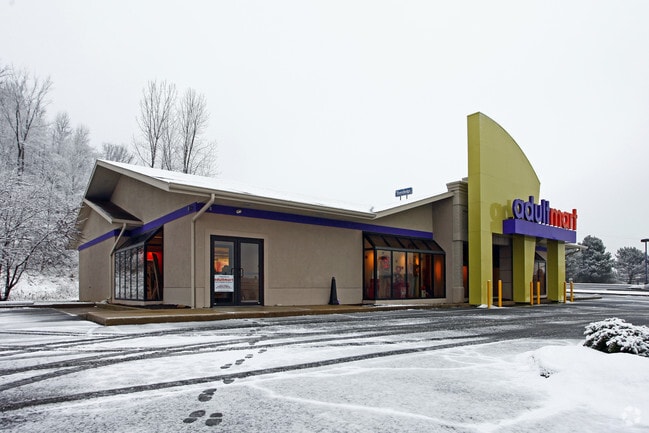
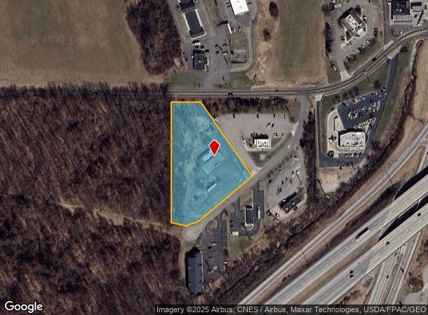
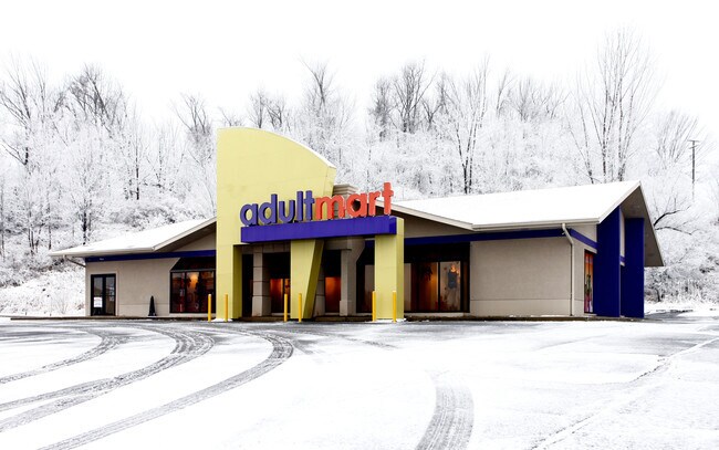
2400 Interstate Cir
056-92-238-98-002
Interstate Subdivision
Storebuilding
22516
X
Richland
39117C0100F
Ohio
2024
2.59 AC
2024
Richland County
002102
Cleveland
5,265 SF
Mansfield, OH
DEMOGRAPHICS near 2400 Interstate Cir
1 mile
3 mile
5 mile
2024 Total Population
663
17,669
50,789
2029 Population
659
17,651
50,957
Pop Growth 2024-2029
(0.60%)
(0.10%)
+ 0.33%
Average Age
44
45
42
2024 Total Households
280
8,122
22,282
HH Growth 2024-2029
(0.36%)
(0.07%)
+ 0.31%
Median Household Inc
$61,000
$49,483
$45,432
Avg Household Size
2.30
2.10
2.20
2024 Avg HH Vehicles
2.00
2.00
2.00
Median Home Value
$171,738
$159,558
$141,034
Median Year Built
1966
1969
1961
Nearby Places
Map Layers
Map Styles
 Street
 Aerial
Transit
 Traffic
 Biking
Places
Listings with unknown addresses are not visible on the map
- Restaurants
- Banks
- Shops
- Fitness
- Groceries
Nearby Properties
Address
Land Use
TOTAL SIZE
Lot Size
Zoning
Address
Land Use
TOTAL SIZE
Lot Size
Zoning
215,214 SF
18.28 AC
Address
Land Use
TOTAL SIZE
Lot Size
Zoning
92,587 SF
48.78 AC
Address
Land Use
TOTAL SIZE
Lot Size
Zoning
32,728 SF
56.23 AC
Address
Land Use
TOTAL SIZE
Lot Size
Zoning
3,714 SF
16.25 AC
Address
Land Use
TOTAL SIZE
Lot Size
Zoning
107,754 SF
3.38 AC
Address
Land Use
TOTAL SIZE
Lot Size
Zoning
76,069 SF
8 AC
Address
Land Use
TOTAL SIZE
Lot Size
Zoning
33,194 SF
5 AC
Address
Land Use
TOTAL SIZE
Lot Size
Zoning
188,928 SF
18.94 AC
Address
Land Use
TOTAL SIZE
Lot Size
Zoning
16,578 SF
8.23 AC
Address
Land Use
TOTAL SIZE
Lot Size
Zoning
39,696 SF
2.03 AC
Address
Land Use
TOTAL SIZE
Lot Size
Zoning
78,288 SF
20.76 AC
Address
Land Use
TOTAL SIZE
Lot Size
Zoning
50,832 SF
1.64 AC
Address
Land Use
TOTAL SIZE
Lot Size
Zoning
1,035 SF
12.53 AC
Address
Land Use
TOTAL SIZE
Lot Size
Zoning
6,400 SF
7.83 AC
Address
Land Use
TOTAL SIZE
Lot Size
Zoning
79,731 SF
10.43 AC
Address
Land Use
TOTAL SIZE
Lot Size
Zoning
39,168 SF
8.02 AC
Address
Land Use
TOTAL SIZE
Lot Size
Zoning
25,895 SF
2.65 AC
Address
Land Use
TOTAL SIZE
Lot Size
Zoning
116,383 SF
63.86 AC
Address
Land Use
TOTAL SIZE
Lot Size
Zoning
14,180 SF
1.32 AC
Address
Land Use
TOTAL SIZE
Lot Size
Zoning
25,261 SF
1.46 AC
Address
Land Use
TOTAL SIZE
Lot Size
Zoning
6,551 SF
2.10 AC
Address
Land Use
TOTAL SIZE
Lot Size
Zoning
4,788 SF
56.83 AC
Address
Land Use
TOTAL SIZE
Lot Size
Zoning
152,142 SF
22.22 AC
Address
Land Use
TOTAL SIZE
Lot Size
Zoning
3,014 SF
5.55 AC
Address
Land Use
TOTAL SIZE
Lot Size
Zoning
71,500 SF
4.70 AC
Address
Land Use
TOTAL SIZE
Lot Size
Zoning
5,320 SF
3.05 AC
Address
Land Use
TOTAL SIZE
Lot Size
Zoning
1,299 SF
2.40 AC
Address
Land Use
TOTAL SIZE
Lot Size
Zoning
49,274 SF
5.46 AC
Address
Land Use
TOTAL SIZE
Lot Size
Zoning
20,636 SF
11 AC
Address
Land Use
TOTAL SIZE
Lot Size
Zoning
9,752 SF
3.22 AC
The World's #1 Commercial Real Estate Marketplace
Connect with us
© 2026 CoStar Group
The information above has been obtained from sources believed reliable. While we do not doubt its accuracy we have not verified it and make no guarantee, warranty or representation about it. It is your responsibility to independently confirm its accuracy and completeness. Any projections, opinions, assumptions, or estimates used are for example only and do not represent the current or future performance of the property. The value of this transaction to you depends on tax and other factors which should be evaluated by your tax, financial, and legal advisors. You and your advisors should conduct a careful, independent investigation of the property to determine to your satisfaction the suitability of the property for your needs.