Property Record
2400 N Marion Rd, Sioux Falls, SD 57107


Property Detail
2400 N Marion Rd
Sioux Falls, SD-MN
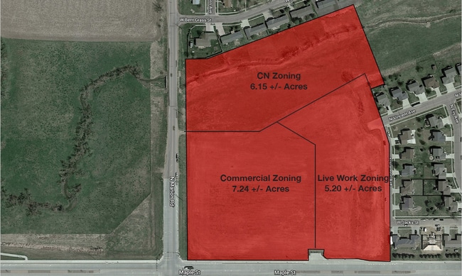
TRACT 1 (EX LOTS H1, H2 & H3) NORTH RIDGE ADDN TO CITY OF SIOUX FALLS
77514
MINNEHAHA
Commercialacreage
South Dakota
FP;FP
h1
AE The base floodplain where base flood elevations are provided. AE Zones are now used on new format FIRMs instead of A1-A30 Zones.
18.58 AC
2024
Sioux Falls
2024
Other Market Areas
010405
NEARBY LISTINGS FOR SALE OR LEASE
DEMOGRAPHICS near 2400 N Marion Rd
1 mile
3 mile
5 mile
2025 Total Population
4,473
30,151
106,597
2030 Population
4,801
31,938
112,069
Pop Growth 2025-2030
+ 7.33%
+ 5.93%
+ 5.13%
Average Age
34
37
38
2025 Total Households
1,864
13,006
45,127
HH Growth 2025-2030
+ 7.94%
+ 6.38%
+ 5.65%
Median Household Inc
$67,500
$63,495
$64,374
Avg Household Size
2.30
2.20
2.20
2025 Avg HH Vehicles
2.00
2.00
2.00
Median Home Value
$279,809
$233,874
$259,383
Median Year Built
2010
1995
1985
Nearby Places
Map Layers
Map Styles
 Street
 Aerial
Transit
 Traffic
 Biking
Places
Listings with unknown addresses are not visible on the map
- Restaurants
- Banks
- Shops
- Fitness
- Groceries
PUBLIC TRANSPORTATION
AIRPORT
Joe Foss Field
Drive
Walk
Distance
Joe Foss Field
11 min
5.0 mi
SALE & LEASE HISTORY
LISTING DATE
SALE/LEASE

Feb 23, 2023
For Sale
Nearby Properties
Address
Land Use
TOTAL SIZE
Lot Size
Zoning
Address
Land Use
TOTAL SIZE
Lot Size
Zoning
193,993 SF
34.68 AC
Address
Land Use
TOTAL SIZE
Lot Size
Zoning
Address
Land Use
TOTAL SIZE
Lot Size
Zoning
77,853 SF
10.42 AC
Address
Land Use
TOTAL SIZE
Lot Size
Zoning
36,986 SF
8.49 AC
FP;FP
Address
Land Use
TOTAL SIZE
Lot Size
Zoning
140,816 SF
13.80 AC
Address
Land Use
TOTAL SIZE
Lot Size
Zoning
35,688 SF
8.27 AC
FP;FP
Address
Land Use
TOTAL SIZE
Lot Size
Zoning
75,786 SF
7.14 AC
Address
Land Use
TOTAL SIZE
Lot Size
Zoning
137,651 SF
22.28 AC
Address
Land Use
TOTAL SIZE
Lot Size
Zoning
146,718 SF
1.65 AC
Address
Land Use
TOTAL SIZE
Lot Size
Zoning
47,142 SF
6.09 AC
Address
Land Use
TOTAL SIZE
Lot Size
Zoning
49.45 AC
C;COMMERCI
Address
Land Use
TOTAL SIZE
Lot Size
Zoning
18.37 AC
Address
Land Use
TOTAL SIZE
Lot Size
Zoning
167,162 SF
17.11 AC
Address
Land Use
TOTAL SIZE
Lot Size
Zoning
168,359 SF
9.65 AC
NO;SPECIAL
Address
Land Use
TOTAL SIZE
Lot Size
Zoning
21,060 SF
6.70 AC
FP;FP
Address
Land Use
TOTAL SIZE
Lot Size
Zoning
23.87 AC
Address
Land Use
TOTAL SIZE
Lot Size
Zoning
134,102 SF
11.77 AC
Address
Land Use
TOTAL SIZE
Lot Size
Zoning
Address
Land Use
TOTAL SIZE
Lot Size
Zoning
58,825 SF
20.09 AC
Address
Land Use
TOTAL SIZE
Lot Size
Zoning
53,738 SF
6.04 AC
Address
Land Use
TOTAL SIZE
Lot Size
Zoning
30,712 SF
2 AC
C;COMMERCI
Address
Land Use
TOTAL SIZE
Lot Size
Zoning
1.92 AC
C;COMMERCI
Address
Land Use
TOTAL SIZE
Lot Size
Zoning
60,929 SF
13.18 AC
Address
Land Use
TOTAL SIZE
Lot Size
Zoning
85,272 SF
4.83 AC
Address
Land Use
TOTAL SIZE
Lot Size
Zoning
189,766 SF
16.53 AC
I1;LIGHT I
Address
Land Use
TOTAL SIZE
Lot Size
Zoning
1.84 AC
C;COMMERCI
Address
Land Use
TOTAL SIZE
Lot Size
Zoning
Address
Land Use
TOTAL SIZE
Lot Size
Zoning
11.65 AC
I1;LIGHT I
Address
Land Use
TOTAL SIZE
Lot Size
Zoning
72,342 SF
6.09 AC
FP;FP
Address
Land Use
TOTAL SIZE
Lot Size
Zoning
123,701 SF
7.03 AC
FP;FP
The World's #1 Commercial Real Estate Marketplace
Connect with us
© 2026 CoStar Group
The information above has been obtained from sources believed reliable. While we do not doubt its accuracy we have not verified it and make no guarantee, warranty or representation about it. It is your responsibility to independently confirm its accuracy and completeness. Any projections, opinions, assumptions, or estimates used are for example only and do not represent the current or future performance of the property. The value of this transaction to you depends on tax and other factors which should be evaluated by your tax, financial, and legal advisors. You and your advisors should conduct a careful, independent investigation of the property to determine to your satisfaction the suitability of the property for your needs.