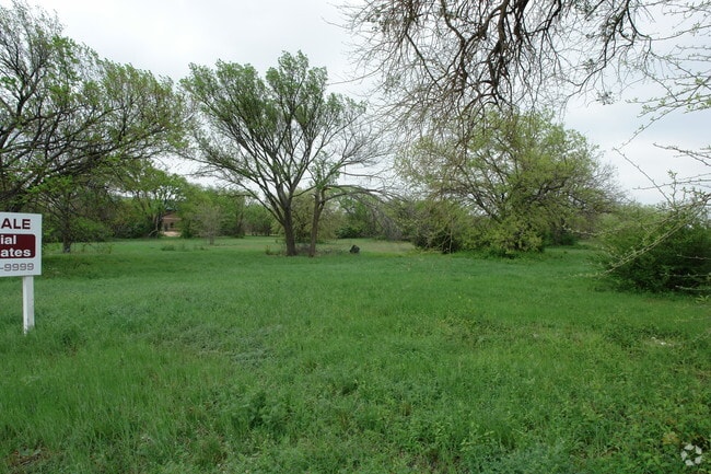
Property Record
2400 Marsh Ln, Carrollton, TX 75006

NEARBY LISTINGS FOR SALE OR LEASE
Property Detail
2400 Marsh Ln
Dallas/Ft Worth
Mathias Ward
Dallas-Fort Worth-Arlington, TX
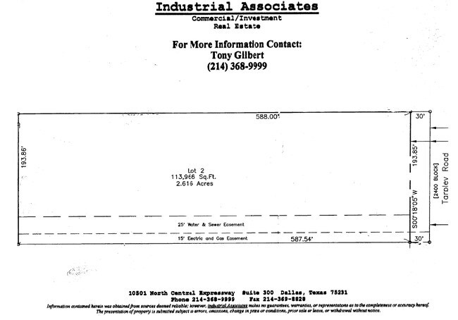
MATHIAS WARD ABST 1603 PG 020 PT TRS 5 & 6 3.64 ACS 1603020100900 11416030201
65160302010090000
Dallas
Utilities
Texas
2024
3.64 AC
2025
Quorum/Bent Tree
013722
DEMOGRAPHICS near 2400 Marsh Ln
1 mile
3 mile
5 mile
2024 Total Population
12,910
155,988
369,254
2029 Population
13,402
171,088
405,469
Pop Growth 2024-2029
+ 3.81%
+ 9.68%
+ 9.81%
Average Age
39
38
39
2024 Total Households
6,173
73,454
160,550
HH Growth 2024-2029
+ 4.21%
+ 9.89%
+ 10.11%
Median Household Inc
$70,177
$69,079
$77,340
Avg Household Size
2.10
2.10
2.20
2024 Avg HH Vehicles
2.00
2.00
2.00
Median Home Value
$312,793
$321,280
$376,468
Median Year Built
1987
1986
1986
Nearby Places
Map Layers
Map Styles
 Street
 Aerial
Transit
 Traffic
 Biking
Places
Listings with unknown addresses are not visible on the map
- Restaurants
- Banks
- Shops
- Fitness
- Groceries
PUBLIC TRANSPORTATION
COMMUTER RAIL
Trinity Mills Station (Green Line - Dallas Area Rapid Transit (DART))
Drive
Walk
Distance
Trinity Mills Station (Green Line - Dallas Area Rapid Transit (DART))
10 min
5.6 mi
Hebron Station (A-train - Denton County Transportation Authority)
Drive
Walk
Distance
Hebron Station (A-train - Denton County Transportation Authority)
15 min
9.2 mi
AIRPORT
Dallas Love Field
Drive
Walk
Distance
Dallas Love Field
23 min
14.2 mi
Dallas-Fort Worth International
Drive
Walk
Distance
Dallas-Fort Worth International
24 min
18.2 mi
Freight Ports
Port of Shreveport
Drive
Walk
Distance
Port of Shreveport
226 min
207.5 mi
Nearby Properties
Address
Land Use
TOTAL SIZE
Lot Size
Zoning
Address
Land Use
TOTAL SIZE
Lot Size
Zoning
1,034,981 SF
8.37 AC
Z422
Address
Land Use
TOTAL SIZE
Lot Size
Zoning
1,406,300 SF
6.86 AC
Z236
Address
Land Use
TOTAL SIZE
Lot Size
Zoning
619,645 SF
5.16 AC
Z422
Address
Land Use
TOTAL SIZE
Lot Size
Zoning
597,347 SF
4.40 AC
Z09
Address
Land Use
TOTAL SIZE
Lot Size
Zoning
602,424 SF
31.61 AC
Z236
Address
Land Use
TOTAL SIZE
Lot Size
Zoning
417,990 SF
10.42 AC
Address
Land Use
TOTAL SIZE
Lot Size
Zoning
599,705 SF
4.98 AC
Z32
Address
Land Use
TOTAL SIZE
Lot Size
Zoning
429,576 SF
22.03 AC
Z236
Address
Land Use
TOTAL SIZE
Lot Size
Zoning
482,025 SF
11.73 AC
LC
Address
Land Use
TOTAL SIZE
Lot Size
Zoning
1,294,505 SF
7.25 AC
SU
Address
Land Use
TOTAL SIZE
Lot Size
Zoning
113,688 SF
72.86 AC
Z274
Address
Land Use
TOTAL SIZE
Lot Size
Zoning
696,563 SF
19.77 AC
Z239
Address
Land Use
TOTAL SIZE
Lot Size
Zoning
435,696 SF
3 AC
PD
Address
Land Use
TOTAL SIZE
Lot Size
Zoning
284,890 SF
40.44 AC
Z274
Address
Land Use
TOTAL SIZE
Lot Size
Zoning
561,142 SF
4.64 AC
MU-2
Address
Land Use
TOTAL SIZE
Lot Size
Zoning
595,188 SF
6.16 AC
Z239
Address
Land Use
TOTAL SIZE
Lot Size
Zoning
384,424 SF
377.56 AC
Z119
Address
Land Use
TOTAL SIZE
Lot Size
Zoning
561,139 SF
3.64 AC
Z09
Address
Land Use
TOTAL SIZE
Lot Size
Zoning
490,795 SF
9.59 AC
Z118
Address
Land Use
TOTAL SIZE
Lot Size
Zoning
660,842 SF
4.82 AC
Z09
Address
Land Use
TOTAL SIZE
Lot Size
Zoning
739,099 SF
3.34 AC
Z236
Address
Land Use
TOTAL SIZE
Lot Size
Zoning
584,128 SF
3.51 AC
Z241
Address
Land Use
TOTAL SIZE
Lot Size
Zoning
517,362 SF
23.61 AC
MF-2
Address
Land Use
TOTAL SIZE
Lot Size
Zoning
396,669 SF
18.50 AC
Address
Land Use
TOTAL SIZE
Lot Size
Zoning
1,130,618 SF
6.01 AC
Z32
Address
Land Use
TOTAL SIZE
Lot Size
Zoning
534,929 SF
4.19 AC
Z236
Address
Land Use
TOTAL SIZE
Lot Size
Zoning
349,372 SF
1.31 AC
Z236
Address
Land Use
TOTAL SIZE
Lot Size
Zoning
511,780 SF
5.88 AC
Z31
Address
Land Use
TOTAL SIZE
Lot Size
Zoning
398,442 SF
5.79 AC
Z163
Address
Land Use
TOTAL SIZE
Lot Size
Zoning
787,326 SF
7.39 AC
Z181
The World's #1 Commercial Real Estate Marketplace
Connect with us
© 2026 CoStar Group
The information above has been obtained from sources believed reliable. While we do not doubt its accuracy we have not verified it and make no guarantee, warranty or representation about it. It is your responsibility to independently confirm its accuracy and completeness. Any projections, opinions, assumptions, or estimates used are for example only and do not represent the current or future performance of the property. The value of this transaction to you depends on tax and other factors which should be evaluated by your tax, financial, and legal advisors. You and your advisors should conduct a careful, independent investigation of the property to determine to your satisfaction the suitability of the property for your needs.