Property Record
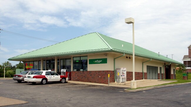
2400 Highway 109, Wildwood, MO 63040


Property Detail
2400 Highway 109
23V-12-0083
SEC 1 TWN 44 R 3 & DRIENHOEFER ESTATE LOT PT 2 BDY ADJ PARCEL A (23V120050 6 2 87)
Servicestation
Saint Louis
NU
Missouri
B and X Area of moderate flood hazard, usually the area between the limits of the 100-year and 500-year floods.
2
2024
1.61 AC
2025
West County
221625
St. Louis
4,438 SF
St. Louis, MO-IL
NEARBY LISTINGS FOR SALE OR LEASE
DEMOGRAPHICS near 2400 Highway 109
1 mile
3 mile
5 mile
2025 Total Population
6,264
30,694
70,272
2030 Population
6,317
30,326
69,512
Pop Growth 2025-2030
+ 0.85%
(1.20%)
(1.08%)
Average Age
42
42
42
2025 Total Households
2,430
11,292
25,796
HH Growth 2025-2030
+ 0.91%
(1.21%)
(1.09%)
Median Household Inc
$124,404
$146,390
$148,374
Avg Household Size
2.50
2.70
2.70
2025 Avg HH Vehicles
2.00
2.00
2.00
Median Home Value
$397,750
$451,876
$454,053
Median Year Built
1993
1990
1988
Nearby Places
Map Layers
Map Styles
 Street
 Aerial
Layers
 Traffic
 Biking
Places
Listings with unknown addresses are not visible on the map
- Restaurants
- Banks
- Shops
- Fitness
- Groceries
PUBLIC TRANSPORTATION
AIRPORT
St Louis Lambert International
Drive
Walk
Distance
St Louis Lambert International
45 min
29.9 mi
SALE & LEASE HISTORY
LISTING DATE
SALE/LEASE

Sep 04, 2020
For Sale
Mar 08, 2017
For Sale
Aug 17, 2021
For Sale
Nearby Properties
Address
Land Use
TOTAL SIZE
Lot Size
Zoning
Address
Land Use
TOTAL SIZE
Lot Size
Zoning
51.20 AC
NU
Address
Land Use
TOTAL SIZE
Lot Size
Zoning
5,675 SF
1,382.01 AC
PS
Address
Land Use
TOTAL SIZE
Lot Size
Zoning
85,946 SF
60.44 AC
NU
Address
Land Use
TOTAL SIZE
Lot Size
Zoning
313,104 SF
14.66 AC
MXD
Address
Land Use
TOTAL SIZE
Lot Size
Zoning
138,056 SF
17.42 AC
NU
Address
Land Use
TOTAL SIZE
Lot Size
Zoning
175,448 SF
6.95 AC
Address
Land Use
TOTAL SIZE
Lot Size
Zoning
27.86 AC
107NU
Address
Land Use
TOTAL SIZE
Lot Size
Zoning
68.69 AC
107NU
Address
Land Use
TOTAL SIZE
Lot Size
Zoning
30 AC
107NU
Address
Land Use
TOTAL SIZE
Lot Size
Zoning
16.80 AC
NU
Address
Land Use
TOTAL SIZE
Lot Size
Zoning
164,430 SF
9.85 AC
19C-4
Address
Land Use
TOTAL SIZE
Lot Size
Zoning
247,511 SF
31.03 AC
19M-1
Address
Land Use
TOTAL SIZE
Lot Size
Zoning
3,750 SF
169.58 AC
107NU
Address
Land Use
TOTAL SIZE
Lot Size
Zoning
4,464 SF
12.30 AC
107NU
Address
Land Use
TOTAL SIZE
Lot Size
Zoning
7,250 SF
80.06 AC
R
Address
Land Use
TOTAL SIZE
Lot Size
Zoning
185,087 SF
8 AC
19C-4
Address
Land Use
TOTAL SIZE
Lot Size
Zoning
118,097 SF
14.32 AC
19C-4
Address
Land Use
TOTAL SIZE
Lot Size
Zoning
97,285 SF
13.66 AC
19R-1
Address
Land Use
TOTAL SIZE
Lot Size
Zoning
222,707 SF
13.82 AC
19C-1
Address
Land Use
TOTAL SIZE
Lot Size
Zoning
109,550 SF
14.21 AC
107R6A
Address
Land Use
TOTAL SIZE
Lot Size
Zoning
7,208 SF
29.36 AC
107NU
Address
Land Use
TOTAL SIZE
Lot Size
Zoning
17.18 AC
R1A
Address
Land Use
TOTAL SIZE
Lot Size
Zoning
11.91 AC
107R3
Address
Land Use
TOTAL SIZE
Lot Size
Zoning
9.89 AC
19R-1
Address
Land Use
TOTAL SIZE
Lot Size
Zoning
9.64 AC
19R-1
Address
Land Use
TOTAL SIZE
Lot Size
Zoning
12.76 AC
A
Address
Land Use
TOTAL SIZE
Lot Size
Zoning
37.37 AC
107NU
Address
Land Use
TOTAL SIZE
Lot Size
Zoning
73,053 SF
1.65 AC
107NU
Address
Land Use
TOTAL SIZE
Lot Size
Zoning
50,846 SF
6.52 AC
107NU
Address
Land Use
TOTAL SIZE
Lot Size
Zoning
15.82 AC
107NU
The World's #1 Commercial Real Estate Marketplace
Connect with us
© 2026 CoStar Group
The information above has been obtained from sources believed reliable. While we do not doubt its accuracy we have not verified it and make no guarantee, warranty or representation about it. It is your responsibility to independently confirm its accuracy and completeness. Any projections, opinions, assumptions, or estimates used are for example only and do not represent the current or future performance of the property. The value of this transaction to you depends on tax and other factors which should be evaluated by your tax, financial, and legal advisors. You and your advisors should conduct a careful, independent investigation of the property to determine to your satisfaction the suitability of the property for your needs.