Property Record
2400 Mounds View Blvd, Saint Paul, MN 55112

NEARBY LISTINGS FOR SALE OR LEASE
Property Detail
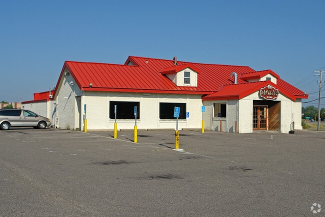
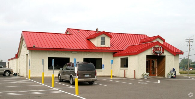
2400 Mounds View Blvd
08-30-23-24-0059
Section 8 Town 30 Range 23
Restaurantbuilding
SECTION 8 TOWN 30 RANGE 23 PART OF SE 1/4 OF NW 1/4 LYING SWLY OF C/L ...& HWY 10) IN SEC 8 TN 30 RN 23
X
Ramsey
27053C0250F
Minnesota
2024
0.86 AC
2025
Rosedale
040902
Minneapolis/St Paul
10,758 SF
Minneapolis-St. Paul-Bloomington, MN-WI
DEMOGRAPHICS near 2400 Mounds View Blvd
1 Mile
3 Mile
5 Mile
2024 Total Population
10,441
64,920
188,591
2029 Population
10,176
65,297
190,284
Pop Growth 2024-2029
(2.54%)
+ 0.58%
+ 0.90%
Average Age
38
40
40
2024 Total Households
4,100
25,488
74,060
HH Growth 2024-2029
(2.88%)
+ 0.49%
+ 0.87%
Median Household Inc
$77,287
$80,214
$79,299
Avg Household Size
2.50
2.50
2.50
2024 Avg HH Vehicles
2.00
2.00
2.00
Median Home Value
$257,851
$278,860
$278,980
Median Year Built
1974
1975
1975
Nearby Places
Map Layers
Map Styles
 Street
 Aerial
- Restaurants
- Banks
- Shops
- Fitness
- Groceries
PUBLIC TRANSPORTATION
COMMUTER RAIL
Fridley Station (Northstar Corridor - Northstar Commuter Rail)
DRIVE
WALK
Distance
Fridley Station (Northstar Corridor - Northstar Commuter Rail)
12 min
5.2 mi
AIRPORT
Minneapolis-St Paul International/Wold-Chamberlain
DRIVE
WALK
Distance
Minneapolis-St Paul International/Wold-Chamberlain
34 min
22.5 mi
Nearby Properties
Address
Land Use
TOTAL SIZE
Lot Size
Zoning
Address
Land Use
TOTAL SIZE
Lot Size
Zoning
2,443,869 SF
31.79 AC
Address
Land Use
TOTAL SIZE
Lot Size
Zoning
467.27 AC
Address
Land Use
TOTAL SIZE
Lot Size
Zoning
372.05 AC
Address
Land Use
TOTAL SIZE
Lot Size
Zoning
141,716 SF
567.20 AC
Address
Land Use
TOTAL SIZE
Lot Size
Zoning
47,727 SF
17.03 AC
Address
Land Use
TOTAL SIZE
Lot Size
Zoning
35,488 SF
39.07 AC
Address
Land Use
TOTAL SIZE
Lot Size
Zoning
663,908 SF
109.91 AC
Address
Land Use
TOTAL SIZE
Lot Size
Zoning
33,060 SF
20.14 AC
Address
Land Use
TOTAL SIZE
Lot Size
Zoning
66,342 SF
8.85 AC
Address
Land Use
TOTAL SIZE
Lot Size
Zoning
223.30 AC
Address
Land Use
TOTAL SIZE
Lot Size
Zoning
Address
Land Use
TOTAL SIZE
Lot Size
Zoning
260,375 SF
4.24 AC
Address
Land Use
TOTAL SIZE
Lot Size
Zoning
229,420 SF
4.14 AC
Address
Land Use
TOTAL SIZE
Lot Size
Zoning
3.83 AC
Address
Land Use
TOTAL SIZE
Lot Size
Zoning
606,798 SF
49.16 AC
Address
Land Use
TOTAL SIZE
Lot Size
Zoning
21.94 AC
Address
Land Use
TOTAL SIZE
Lot Size
Zoning
539,671 SF
26.93 AC
Address
Land Use
TOTAL SIZE
Lot Size
Zoning
109.41 AC
Address
Land Use
TOTAL SIZE
Lot Size
Zoning
115.62 AC
Address
Land Use
TOTAL SIZE
Lot Size
Zoning
334,568 SF
30.27 AC
Address
Land Use
TOTAL SIZE
Lot Size
Zoning
309,863 SF
56.34 AC
Address
Land Use
TOTAL SIZE
Lot Size
Zoning
27,175 SF
1.86 AC
Address
Land Use
TOTAL SIZE
Lot Size
Zoning
Address
Land Use
TOTAL SIZE
Lot Size
Zoning
208 SF
228 AC
Address
Land Use
TOTAL SIZE
Lot Size
Zoning
194,221 SF
27.83 AC
Address
Land Use
TOTAL SIZE
Lot Size
Zoning
1,260 SF
3.40 AC
Address
Land Use
TOTAL SIZE
Lot Size
Zoning
186,928 SF
4.07 AC
Address
Land Use
TOTAL SIZE
Lot Size
Zoning
196 SF
9.81 AC
Address
Land Use
TOTAL SIZE
Lot Size
Zoning
Address
Land Use
TOTAL SIZE
Lot Size
Zoning
146,862 SF
41.08 AC
The World's #1 Commercial Real Estate Marketplace
Connect with us
© 2026 CoStar Group
The information above has been obtained from sources believed reliable. While we do not doubt its accuracy we have not verified it and make no guarantee, warranty or representation about it. It is your responsibility to independently confirm its accuracy and completeness. Any projections, opinions, assumptions, or estimates used are for example only and do not represent the current or future performance of the property. The value of this transaction to you depends on tax and other factors which should be evaluated by your tax, financial, and legal advisors. You and your advisors should conduct a careful, independent investigation of the property to determine to your satisfaction the suitability of the property for your needs.