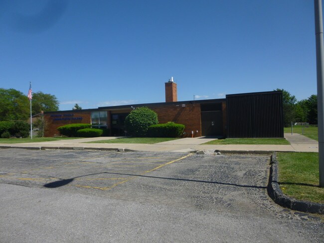
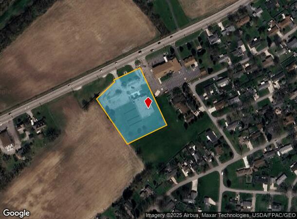
Property Record
2400 N Dixie Hwy, Monroe, MI 48162
NEARBY LISTINGS FOR SALE OR LEASE
Property Detail
2400 N Dixie Hwy
Monroe, MI
SEC 35 T6S R9E PC 476 2.43 AMOL (SURVEY) BEG AT PT S 67 DEG 18'W 53.01 FT TO PT FR NW COR OF OUTLOT B, ALG S ROW LI DIXIE HWY
07-057-001-10
Monroe
Commercialnec
Michigan
X
b
26115C0262F
2.43 AC
2024
Monroe County
2025
Detroit
831300
DEMOGRAPHICS near 2400 N Dixie Hwy
1 Mile
3 Mile
5 Mile
2024 Total Population
3,037
14,589
48,944
2029 Population
3,100
14,854
49,668
Pop Growth 2024-2029
+ 2.07%
+ 1.82%
+ 1.48%
Average Age
43
42
41
2024 Total Households
1,215
5,898
19,981
HH Growth 2024-2029
+ 2.06%
+ 1.71%
+ 1.41%
Median Household Inc
$65,719
$67,023
$61,038
Avg Household Size
2.50
2.40
2.30
2024 Avg HH Vehicles
2.00
2.00
2.00
Median Home Value
$136,309
$168,471
$159,205
Median Year Built
1954
1963
1967
Nearby Places
Map Layers
Map Styles
 Street
 Aerial
- Restaurants
- Banks
- Shops
- Fitness
- Groceries
PUBLIC TRANSPORTATION
AIRPORT
Detroit Metro Wayne County
DRIVE
WALK
Distance
Detroit Metro Wayne County
30 min
23.9 mi
Freight Ports
Port of Toledo
DRIVE
WALK
Distance
Port of Toledo
37 min
26.6 mi
SALE & LEASE HISTORY
LISTING DATE
SALE/LEASE

Feb 08, 2018
For Sale
Nearby Properties
Address
Land Use
TOTAL SIZE
Lot Size
Zoning
Address
Land Use
TOTAL SIZE
Lot Size
Zoning
5,088 SF
123.61 AC
R-1A
Address
Land Use
TOTAL SIZE
Lot Size
Zoning
409,765 SF
41.46 AC
Address
Land Use
TOTAL SIZE
Lot Size
Zoning
315,000 SF
24.47 AC
Address
Land Use
TOTAL SIZE
Lot Size
Zoning
3.97 AC
Address
Land Use
TOTAL SIZE
Lot Size
Zoning
507.34 AC
R-1A
Address
Land Use
TOTAL SIZE
Lot Size
Zoning
134,464 SF
34.35 AC
Address
Land Use
TOTAL SIZE
Lot Size
Zoning
69,590 SF
11.55 AC
C-2-COMMER
Address
Land Use
TOTAL SIZE
Lot Size
Zoning
291,322 SF
55.05 AC
Address
Land Use
TOTAL SIZE
Lot Size
Zoning
PS PUBLIC
Address
Land Use
TOTAL SIZE
Lot Size
Zoning
94,324 SF
10.11 AC
Address
Land Use
TOTAL SIZE
Lot Size
Zoning
62,459 SF
2.59 AC
Address
Land Use
TOTAL SIZE
Lot Size
Zoning
290,248 SF
52.03 AC
Address
Land Use
TOTAL SIZE
Lot Size
Zoning
43,127 SF
8.10 AC
Address
Land Use
TOTAL SIZE
Lot Size
Zoning
412,877 SF
22.35 AC
R-1A
Address
Land Use
TOTAL SIZE
Lot Size
Zoning
220,500 SF
31.81 AC
Address
Land Use
TOTAL SIZE
Lot Size
Zoning
200,700 SF
9.95 AC
R-1A
Address
Land Use
TOTAL SIZE
Lot Size
Zoning
75,437 SF
8.74 AC
R-1A
Address
Land Use
TOTAL SIZE
Lot Size
Zoning
Address
Land Use
TOTAL SIZE
Lot Size
Zoning
150,200 SF
5.68 AC
R-1A
Address
Land Use
TOTAL SIZE
Lot Size
Zoning
19,364 SF
30.80 AC
Address
Land Use
TOTAL SIZE
Lot Size
Zoning
106,200 SF
10.83 AC
R-1A
Address
Land Use
TOTAL SIZE
Lot Size
Zoning
151,101 SF
5.16 AC
R-1A
Address
Land Use
TOTAL SIZE
Lot Size
Zoning
66,154 SF
6.22 AC
Address
Land Use
TOTAL SIZE
Lot Size
Zoning
17,546 SF
213.91 AC
Address
Land Use
TOTAL SIZE
Lot Size
Zoning
245,046 SF
20.41 AC
R-1A
Address
Land Use
TOTAL SIZE
Lot Size
Zoning
44,352 SF
3.40 AC
Address
Land Use
TOTAL SIZE
Lot Size
Zoning
28,284 SF
40.92 AC
C-3-COMMER
Address
Land Use
TOTAL SIZE
Lot Size
Zoning
22,192 SF
51.15 AC
R-1A
Address
Land Use
TOTAL SIZE
Lot Size
Zoning
45,792 SF
6.28 AC
Address
Land Use
TOTAL SIZE
Lot Size
Zoning
99,750 SF
6.94 AC
R-1A
The World's #1 Commercial Real Estate Marketplace
Connect with us
© 2026 CoStar Group
The information above has been obtained from sources believed reliable. While we do not doubt its accuracy we have not verified it and make no guarantee, warranty or representation about it. It is your responsibility to independently confirm its accuracy and completeness. Any projections, opinions, assumptions, or estimates used are for example only and do not represent the current or future performance of the property. The value of this transaction to you depends on tax and other factors which should be evaluated by your tax, financial, and legal advisors. You and your advisors should conduct a careful, independent investigation of the property to determine to your satisfaction the suitability of the property for your needs.