Property Record
2400 W Tharpe St, Tallahassee, FL 32303
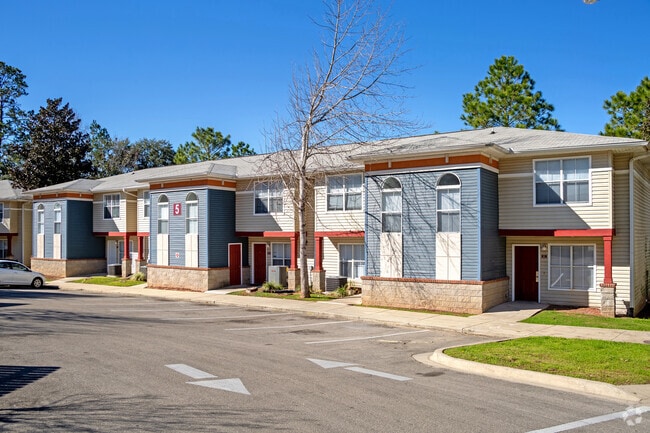


This Property Is For Sale
NEARBY LISTINGS FOR SALE OR LEASE
Property Detail
2400 W Tharpe St
Tallahassee, FL
Plantation Of Fl Pecan Endowm Co 1St Div
21-21-51-019-148.0
SECTION 21 T1N R1W PLANTATION OF TALLAHASSEE PECAN COMPANY PB 1/4 PART OF LOTS 19 20 AND 21 UNITY OF TITLE OR 2612/2164 OR 5789/2068
Multifamilydwelling
Leon
AE
Florida
12073C0279F
19
2025
6.04 AC
2025
Northwest Tallahassee
002101
Tallahassee
92,225 SF
DEMOGRAPHICS near 2400 W Tharpe St
1 Mile
3 Mile
5 Mile
2024 Total Population
14,672
82,202
137,338
2029 Population
15,344
85,604
143,899
Pop Growth 2024-2029
+ 4.58%
+ 4.14%
+ 4.78%
Average Age
30
31
34
2024 Total Households
6,374
34,387
57,871
HH Growth 2024-2029
+ 4.74%
+ 4.17%
+ 4.95%
Median Household Inc
$37,028
$36,519
$43,340
Avg Household Size
2.20
2.10
2.10
2024 Avg HH Vehicles
2.00
2.00
2.00
Median Home Value
$159,317
$163,274
$198,283
Median Year Built
1985
1985
1982
Nearby Places
Map Layers
Map Styles
 Street
 Aerial
- Restaurants
- Banks
- Shops
- Fitness
- Groceries
PUBLIC TRANSPORTATION
AIRPORT
Tallahassee International
DRIVE
WALK
Distance
Tallahassee International
11 min
6.1 mi
Freight Ports
Port of Panama City
DRIVE
WALK
Distance
Port of Panama City
139 min
102.5 mi
Nearby Properties
Address
Land Use
TOTAL SIZE
Lot Size
Zoning
Address
Land Use
TOTAL SIZE
Lot Size
Zoning
1,635,322 SF
29.76 AC
UT
Address
Land Use
TOTAL SIZE
Lot Size
Zoning
6,686,582 SF
86.50 AC
UT
Address
Land Use
TOTAL SIZE
Lot Size
Zoning
4,577,528 SF
108.47 AC
UT
Address
Land Use
TOTAL SIZE
Lot Size
Zoning
3,647,358 SF
49.17 AC
UT
Address
Land Use
TOTAL SIZE
Lot Size
Zoning
1,604,893 SF
175.71 AC
MR1
Address
Land Use
TOTAL SIZE
Lot Size
Zoning
859,455 SF
3.79 AC
CU45
Address
Land Use
TOTAL SIZE
Lot Size
Zoning
704,857 SF
4.95 AC
UT
Address
Land Use
TOTAL SIZE
Lot Size
Zoning
959,505 SF
32.03 AC
M1
Address
Land Use
TOTAL SIZE
Lot Size
Zoning
664,514 SF
2.49 AC
UT
Address
Land Use
TOTAL SIZE
Lot Size
Zoning
369,383 SF
4.51 AC
UT
Address
Land Use
TOTAL SIZE
Lot Size
Zoning
758,762 SF
20.82 AC
UT
Address
Land Use
TOTAL SIZE
Lot Size
Zoning
452,530 SF
10.30 AC
UV
Address
Land Use
TOTAL SIZE
Lot Size
Zoning
719,149 SF
40.73 AC
MR1
Address
Land Use
TOTAL SIZE
Lot Size
Zoning
445,676 SF
23.50 AC
PUD
Address
Land Use
TOTAL SIZE
Lot Size
Zoning
652,729 SF
1.71 AC
UT
Address
Land Use
TOTAL SIZE
Lot Size
Zoning
721,205 SF
6.19 AC
UT
Address
Land Use
TOTAL SIZE
Lot Size
Zoning
414,216 SF
2.23 AC
CU45
Address
Land Use
TOTAL SIZE
Lot Size
Zoning
556,751 SF
20.60 AC
CP
Address
Land Use
TOTAL SIZE
Lot Size
Zoning
859,666 SF
20.17 AC
MR1
Address
Land Use
TOTAL SIZE
Lot Size
Zoning
479,705 SF
9.24 AC
UT
Address
Land Use
TOTAL SIZE
Lot Size
Zoning
538,290 SF
11.05 AC
Address
Land Use
TOTAL SIZE
Lot Size
Zoning
851,869 SF
5.15 AC
DI
Address
Land Use
TOTAL SIZE
Lot Size
Zoning
392,437 SF
10 AC
UT
Address
Land Use
TOTAL SIZE
Lot Size
Zoning
421,095 SF
28.06 AC
MR1
Address
Land Use
TOTAL SIZE
Lot Size
Zoning
225,370 SF
3.76 AC
CU45
Address
Land Use
TOTAL SIZE
Lot Size
Zoning
181,104 SF
1.78 AC
UV
Address
Land Use
TOTAL SIZE
Lot Size
Zoning
459,568 SF
10.10 AC
CU45
Address
Land Use
TOTAL SIZE
Lot Size
Zoning
424,591 SF
2.77 AC
UT
Address
Land Use
TOTAL SIZE
Lot Size
Zoning
883,293 SF
35.97 AC
R4
Address
Land Use
TOTAL SIZE
Lot Size
Zoning
607,000 SF
37.55 AC
PUD
The World's #1 Commercial Real Estate Marketplace
Connect with us
© 2026 CoStar Group
The information above has been obtained from sources believed reliable. While we do not doubt its accuracy we have not verified it and make no guarantee, warranty or representation about it. It is your responsibility to independently confirm its accuracy and completeness. Any projections, opinions, assumptions, or estimates used are for example only and do not represent the current or future performance of the property. The value of this transaction to you depends on tax and other factors which should be evaluated by your tax, financial, and legal advisors. You and your advisors should conduct a careful, independent investigation of the property to determine to your satisfaction the suitability of the property for your needs.