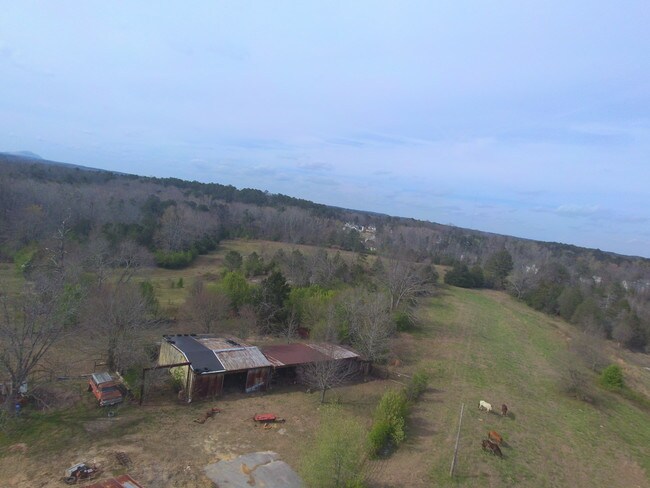
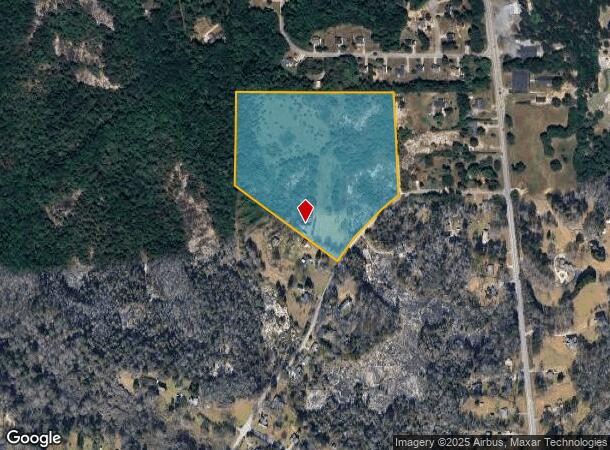
Property Record
2400 Wilson Rd Nw, Conyers, GA 30012
NEARBY LISTINGS FOR SALE OR LEASE
Property Detail
2400 Wilson Rd Nw
Atlanta-Sandy Springs-Roswell, GA
Rural
055-0-01-0079
NW/SIDE WILSON RD
Agriculturalland
Rockdale
X
Georgia
13247C0084D
305
2024
20.79 AC
2024
I-20 East/Conyers
060101
Atlanta
DEMOGRAPHICS near 2400 Wilson Rd Nw
1 Mile
3 Mile
5 Mile
2024 Total Population
1,512
27,355
61,974
2029 Population
1,573
28,384
63,993
Pop Growth 2024-2029
+ 4.03%
+ 3.76%
+ 3.26%
Average Age
41
38
38
2024 Total Households
533
9,552
21,790
HH Growth 2024-2029
+ 4.13%
+ 3.75%
+ 3.28%
Median Household Inc
$80,664
$56,821
$60,948
Avg Household Size
2.70
2.70
2.70
2024 Avg HH Vehicles
2.00
2.00
2.00
Median Home Value
$210,417
$173,578
$210,483
Median Year Built
1980
1986
1988
Nearby Places
Map Layers
Map Styles
 Street
 Aerial
- Restaurants
- Banks
- Shops
- Fitness
- Groceries
PUBLIC TRANSPORTATION
AIRPORT
Hartsfield - Jackson Atlanta International
DRIVE
WALK
Distance
Hartsfield - Jackson Atlanta International
45 min
30.7 mi
Freight Ports
Georgia Ports - Savannah
DRIVE
WALK
Distance
Georgia Ports - Savannah
284 min
242.7 mi
SALE & LEASE HISTORY
LISTING DATE
SALE/LEASE

Feb 05, 2018
For Sale
Nearby Properties
Address
Land Use
TOTAL SIZE
Lot Size
Zoning
Address
Land Use
TOTAL SIZE
Lot Size
Zoning
458,448 SF
12.98 AC
OI
Address
Land Use
TOTAL SIZE
Lot Size
Zoning
3,256 SF
22.05 AC
RM
Address
Land Use
TOTAL SIZE
Lot Size
Zoning
3,066 SF
22.44 AC
R3/R1
Address
Land Use
TOTAL SIZE
Lot Size
Zoning
3,648 SF
1.02 AC
R3/R1
Address
Land Use
TOTAL SIZE
Lot Size
Zoning
417,378 SF
31.95 AC
M1
Address
Land Use
TOTAL SIZE
Lot Size
Zoning
3,888 SF
21.05 AC
RM/C
Address
Land Use
TOTAL SIZE
Lot Size
Zoning
17,800 SF
11.36 AC
RM/C
Address
Land Use
TOTAL SIZE
Lot Size
Zoning
180,890 SF
45.15 AC
R1
Address
Land Use
TOTAL SIZE
Lot Size
Zoning
472,620 SF
55.20 AC
RS10
Address
Land Use
TOTAL SIZE
Lot Size
Zoning
76,140 SF
22.20 AC
RM
Address
Land Use
TOTAL SIZE
Lot Size
Zoning
159,014 SF
3.88 AC
RM
Address
Land Use
TOTAL SIZE
Lot Size
Zoning
28,012 SF
4.04 AC
OI
Address
Land Use
TOTAL SIZE
Lot Size
Zoning
196,560 SF
12.06 AC
MI
Address
Land Use
TOTAL SIZE
Lot Size
Zoning
14,575 SF
14.55 AC
OI
Address
Land Use
TOTAL SIZE
Lot Size
Zoning
110,813 SF
53.11 AC
RM/C
Address
Land Use
TOTAL SIZE
Lot Size
Zoning
105,600 SF
8.75 AC
M1
Address
Land Use
TOTAL SIZE
Lot Size
Zoning
713,040 SF
67.04 AC
M1
Address
Land Use
TOTAL SIZE
Lot Size
Zoning
65,460 SF
32.41 AC
M1
Address
Land Use
TOTAL SIZE
Lot Size
Zoning
15,419 SF
20.15 AC
PUD
Address
Land Use
TOTAL SIZE
Lot Size
Zoning
55,928 SF
14.63 AC
BN
Address
Land Use
TOTAL SIZE
Lot Size
Zoning
145,159 SF
1.13 AC
BN
Address
Land Use
TOTAL SIZE
Lot Size
Zoning
30,396 SF
4.07 AC
BGC
Address
Land Use
TOTAL SIZE
Lot Size
Zoning
29.96 AC
R1
Address
Land Use
TOTAL SIZE
Lot Size
Zoning
27,283 SF
7.30 AC
MXD
Address
Land Use
TOTAL SIZE
Lot Size
Zoning
57,417 SF
11.25 AC
BN
Address
Land Use
TOTAL SIZE
Lot Size
Zoning
66,181 SF
25.46 AC
R1A
Address
Land Use
TOTAL SIZE
Lot Size
Zoning
20,942 SF
22.78 AC
BG
Address
Land Use
TOTAL SIZE
Lot Size
Zoning
36,140 SF
2.74 AC
OI
Address
Land Use
TOTAL SIZE
Lot Size
Zoning
34,370 SF
5.04 AC
OI
Address
Land Use
TOTAL SIZE
Lot Size
Zoning
45,482 SF
0.98 AC
RG
The World's #1 Commercial Real Estate Marketplace
Connect with us
© 2025 CoStar Group
The information above has been obtained from sources believed reliable. While we do not doubt its accuracy we have not verified it and make no guarantee, warranty or representation about it. It is your responsibility to independently confirm its accuracy and completeness. Any projections, opinions, assumptions, or estimates used are for example only and do not represent the current or future performance of the property. The value of this transaction to you depends on tax and other factors which should be evaluated by your tax, financial, and legal advisors. You and your advisors should conduct a careful, independent investigation of the property to determine to your satisfaction the suitability of the property for your needs.