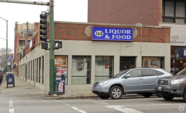
Property Record
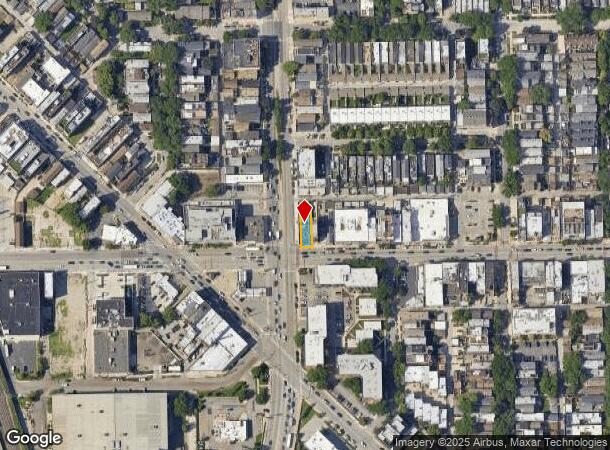
1554 W Fullerton Ave, Chicago, IL 60614
Current Lease Availabilities
NEARBY LISTINGS FOR SALE OR LEASE
Property Detail
1554 W Fullerton Ave
Chicago-Naperville-Elgin, IL-IN-WI
Mueller Sub
14-29-318-024-0000
L (MUELLER) SUB OF LT8 OF ASSESSORS DIVN OF OUTLOT 42 OF SHEFFIELDS ADD TO CHICAGO IN SEC 29-40-14
Commercialbuilding
Cook
X
Illinois
17031C0416J
8
2023
0.90 AC
2024
Lincoln Park
071100
Chicago
3,875 SF
DEMOGRAPHICS near 1554 W Fullerton Ave
1 Mile
3 Mile
5 Mile
2024 Total Population
56,960
540,842
1,109,636
2029 Population
55,426
523,684
1,069,129
Pop Growth 2024-2029
(2.69%)
(3.17%)
(3.65%)
Average Age
33
36
37
2024 Total Households
24,578
276,067
530,466
HH Growth 2024-2029
(2.99%)
(3.17%)
(3.47%)
Median Household Inc
$157,455
$103,127
$89,644
Avg Household Size
2.20
1.90
2.00
2024 Avg HH Vehicles
1.00
1.00
1.00
Median Home Value
$758,233
$529,660
$442,959
Median Year Built
1968
1962
1959
Nearby Places
- Restaurants
- Banks
- Shops
- Fitness
- Groceries
PUBLIC TRANSPORTATION
TRANSIT/SUBWAY
Clybourn Station (Union Pacific North Line - Northeast Illinois Regional Commuter Railroad (Metra), Union Pacific Northwest Line - Northeast Illinois Regional Commuter Railroad (Metra))
DRIVE
WALK
Distance
Clybourn Station (Union Pacific North Line - Northeast Illinois Regional Commuter Railroad (Metra), Union Pacific Northwest Line - Northeast Illinois Regional Commuter Railroad (Metra))
2 min
12 min
0.6 mi
Fullerton Station (Brown Line - Chicago Transit Authority "L" Trains (The "L"), Purple Line - Chicago Transit Authority "L" Trains (The "L"), Red Line - Chicago Transit Authority "L" Trains (The "L"))
DRIVE
WALK
Distance
Fullerton Station (Brown Line - Chicago Transit Authority "L" Trains (The "L"), Purple Line - Chicago Transit Authority "L" Trains (The "L"), Red Line - Chicago Transit Authority "L" Trains (The "L"))
2 min
16 min
0.8 mi
Armitage Station (Brown Line - Chicago Transit Authority "L" Trains (The "L"), Purple Line - Chicago Transit Authority "L" Trains (The "L"))
DRIVE
WALK
Distance
Armitage Station (Brown Line - Chicago Transit Authority "L" Trains (The "L"), Purple Line - Chicago Transit Authority "L" Trains (The "L"))
3 min
20 min
1.1 mi
COMMUTER RAIL
Clybourn Station (Union Pacific North Line - Northeast Illinois Regional Commuter Railroad (Metra), Union Pacific Northwest Line - Northeast Illinois Regional Commuter Railroad (Metra))
DRIVE
WALK
Distance
Clybourn Station (Union Pacific North Line - Northeast Illinois Regional Commuter Railroad (Metra), Union Pacific Northwest Line - Northeast Illinois Regional Commuter Railroad (Metra))
1 min
12 min
0.6 mi
Healy Station (Milwaukee District North Line - Northeast Illinois Regional Commuter Railroad (Metra))
DRIVE
WALK
Distance
Healy Station (Milwaukee District North Line - Northeast Illinois Regional Commuter Railroad (Metra))
7 min
3.1 mi
AIRPORT
Chicago Midway International
DRIVE
WALK
Distance
Chicago Midway International
23 min
12.4 mi
Chicago O'Hare International
DRIVE
WALK
Distance
Chicago O'Hare International
22 min
14.2 mi
Nearby Properties
Address
Land Use
TOTAL SIZE
Lot Size
Zoning
Address
Land Use
TOTAL SIZE
Lot Size
Zoning
831,084 SF
2.05 AC
PD 316
Address
Land Use
TOTAL SIZE
Lot Size
Zoning
1,502,279 SF
3.79 AC
PD 98
Address
Land Use
TOTAL SIZE
Lot Size
Zoning
1.09 AC
B1-3
Address
Land Use
TOTAL SIZE
Lot Size
Zoning
559,589 SF
1.72 AC
C3-5
Address
Land Use
TOTAL SIZE
Lot Size
Zoning
0.72 AC
PD 1403
Address
Land Use
TOTAL SIZE
Lot Size
Zoning
1,857,394 SF
3.13 AC
PD 447
Address
Land Use
TOTAL SIZE
Lot Size
Zoning
491,382 SF
2.05 AC
PD 316
Address
Land Use
TOTAL SIZE
Lot Size
Zoning
1,284,706 SF
4.40 AC
Address
Land Use
TOTAL SIZE
Lot Size
Zoning
403,219 SF
1.42 AC
DX-12,DX-1
Address
Land Use
TOTAL SIZE
Lot Size
Zoning
433,026 SF
0.47 AC
DX-12
Address
Land Use
TOTAL SIZE
Lot Size
Zoning
229,725 SF
1.21 AC
DX-12,DX-1
Address
Land Use
TOTAL SIZE
Lot Size
Zoning
1,578,363 SF
2.62 AC
DX-12
Address
Land Use
TOTAL SIZE
Lot Size
Zoning
1.36 AC
DX-12
Address
Land Use
TOTAL SIZE
Lot Size
Zoning
1,412,950 SF
1.03 AC
DX-12
Address
Land Use
TOTAL SIZE
Lot Size
Zoning
228,018 SF
8.72 AC
PD 958
Address
Land Use
TOTAL SIZE
Lot Size
Zoning
309,985 SF
0.78 AC
PD 1418
Address
Land Use
TOTAL SIZE
Lot Size
Zoning
549,130 SF
1.45 AC
DX-12
Address
Land Use
TOTAL SIZE
Lot Size
Zoning
594,987 SF
1.11 AC
PD 1407
Address
Land Use
TOTAL SIZE
Lot Size
Zoning
0.77 AC
PD 819
Address
Land Use
TOTAL SIZE
Lot Size
Zoning
317,932 SF
0.97 AC
PD 1306
Address
Land Use
TOTAL SIZE
Lot Size
Zoning
222,240 SF
2.45 AC
PD 1439
Address
Land Use
TOTAL SIZE
Lot Size
Zoning
275,000 SF
3.26 AC
PD 106
Address
Land Use
TOTAL SIZE
Lot Size
Zoning
500,000 SF
1.13 AC
PD 106
Address
Land Use
TOTAL SIZE
Lot Size
Zoning
935,613 SF
1.79 AC
PD 237
Address
Land Use
TOTAL SIZE
Lot Size
Zoning
266,248 SF
Address
Land Use
TOTAL SIZE
Lot Size
Zoning
2,087,700 SF
0.96 AC
PD 98
Address
Land Use
TOTAL SIZE
Lot Size
Zoning
602,197 SF
Address
Land Use
TOTAL SIZE
Lot Size
Zoning
623,912 SF
Address
Land Use
TOTAL SIZE
Lot Size
Zoning
613,775 SF
0.41 AC
PD 1403
Address
Land Use
TOTAL SIZE
Lot Size
Zoning
61,300 SF
0.30 AC
B3-5
The World's #1 Commercial Real Estate Marketplace
Connect with us
© 2025 CoStar Group
The information above has been obtained from sources believed reliable. While we do not doubt its accuracy we have not verified it and make no guarantee, warranty or representation about it. It is your responsibility to independently confirm its accuracy and completeness. Any projections, opinions, assumptions, or estimates used are for example only and do not represent the current or future performance of the property. The value of this transaction to you depends on tax and other factors which should be evaluated by your tax, financial, and legal advisors. You and your advisors should conduct a careful, independent investigation of the property to determine to your satisfaction the suitability of the property for your needs.