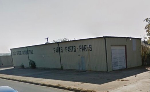
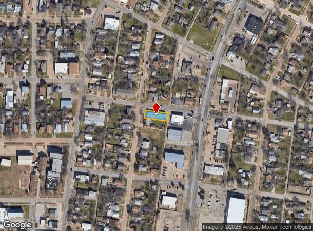
Property Record
2401 Buchanan St, Wichita Falls, TX 76309
NEARBY LISTINGS FOR SALE OR LEASE
Property Detail
2401 Buchanan St
Wichita Falls, TX
Highland Addition
146248
LOT 16 BLK 11A HIGHLAND
Warehouse
Wichita
X
Texas
48485C0320G
16
2024
0.17 AC
2025
West Wichita Falls
012700
Other Market Areas
3,600 SF
DEMOGRAPHICS near 2401 Buchanan St
1 Mile
3 Mile
5 Mile
2024 Total Population
11,523
56,832
94,657
2029 Population
11,825
58,131
96,843
Pop Growth 2024-2029
+ 2.62%
+ 2.29%
+ 2.31%
Average Age
38
39
39
2024 Total Households
4,710
23,212
36,790
HH Growth 2024-2029
+ 2.63%
+ 2.33%
+ 2.47%
Median Household Inc
$46,601
$52,413
$51,412
Avg Household Size
2.30
2.30
2.30
2024 Avg HH Vehicles
2.00
2.00
2.00
Median Home Value
$108,085
$138,692
$133,030
Median Year Built
1956
1966
1970
Nearby Places
Map Layers
Map Styles
 Street
 Aerial
- Restaurants
- Banks
- Shops
- Fitness
- Groceries
SALE & LEASE HISTORY
LISTING DATE
SALE/LEASE

Feb 06, 2021
For Lease
Nearby Properties
Address
Land Use
TOTAL SIZE
Lot Size
Zoning
Address
Land Use
TOTAL SIZE
Lot Size
Zoning
1,172,641 SF
100 AC
Address
Land Use
TOTAL SIZE
Lot Size
Zoning
164,255 SF
5.23 AC
Address
Land Use
TOTAL SIZE
Lot Size
Zoning
398,646 SF
7.51 AC
GC
Address
Land Use
TOTAL SIZE
Lot Size
Zoning
45,719 SF
35.31 AC
Address
Land Use
TOTAL SIZE
Lot Size
Zoning
203,569 SF
27.74 AC
Address
Land Use
TOTAL SIZE
Lot Size
Zoning
245,000 SF
37 AC
SF2
Address
Land Use
TOTAL SIZE
Lot Size
Zoning
245,152 SF
5.12 AC
GC
Address
Land Use
TOTAL SIZE
Lot Size
Zoning
275,676 SF
22.58 AC
Address
Land Use
TOTAL SIZE
Lot Size
Zoning
247,406 SF
10 AC
Address
Land Use
TOTAL SIZE
Lot Size
Zoning
157,968 SF
7.40 AC
GC
Address
Land Use
TOTAL SIZE
Lot Size
Zoning
24,741 SF
37.75 AC
Address
Land Use
TOTAL SIZE
Lot Size
Zoning
129,655 SF
Address
Land Use
TOTAL SIZE
Lot Size
Zoning
266,509 SF
14.25 AC
SF2
Address
Land Use
TOTAL SIZE
Lot Size
Zoning
200,421 SF
18.57 AC
MFR
Address
Land Use
TOTAL SIZE
Lot Size
Zoning
130,756 SF
14.82 AC
Address
Land Use
TOTAL SIZE
Lot Size
Zoning
138,336 SF
18.97 AC
GC
Address
Land Use
TOTAL SIZE
Lot Size
Zoning
167,247 SF
2.61 AC
CBD
Address
Land Use
TOTAL SIZE
Lot Size
Zoning
51,240 SF
3.46 AC
GC
Address
Land Use
TOTAL SIZE
Lot Size
Zoning
158,687 SF
14.68 AC
GC
Address
Land Use
TOTAL SIZE
Lot Size
Zoning
62,791 SF
63.60 AC
Address
Land Use
TOTAL SIZE
Lot Size
Zoning
784,240 SF
58.86 AC
GC
Address
Land Use
TOTAL SIZE
Lot Size
Zoning
151,854 SF
5.11 AC
Address
Land Use
TOTAL SIZE
Lot Size
Zoning
189,192 SF
9.24 AC
GC
Address
Land Use
TOTAL SIZE
Lot Size
Zoning
78,105 SF
6.66 AC
Address
Land Use
TOTAL SIZE
Lot Size
Zoning
125,992 SF
4.22 AC
Address
Land Use
TOTAL SIZE
Lot Size
Zoning
80,294 SF
9.17 AC
Address
Land Use
TOTAL SIZE
Lot Size
Zoning
226,866 SF
12.10 AC
MFR
Address
Land Use
TOTAL SIZE
Lot Size
Zoning
136,522 SF
4.11 AC
Address
Land Use
TOTAL SIZE
Lot Size
Zoning
69,483 SF
30 AC
Address
Land Use
TOTAL SIZE
Lot Size
Zoning
82,217 SF
10.57 AC
SF2
The World's #1 Commercial Real Estate Marketplace
Connect with us
© 2025 CoStar Group
The information above has been obtained from sources believed reliable. While we do not doubt its accuracy we have not verified it and make no guarantee, warranty or representation about it. It is your responsibility to independently confirm its accuracy and completeness. Any projections, opinions, assumptions, or estimates used are for example only and do not represent the current or future performance of the property. The value of this transaction to you depends on tax and other factors which should be evaluated by your tax, financial, and legal advisors. You and your advisors should conduct a careful, independent investigation of the property to determine to your satisfaction the suitability of the property for your needs.