Property Record
2401 Se 5Th Cir, Ocala, FL 34471
NEARBY LISTINGS FOR SALE OR LEASE
Property Detail
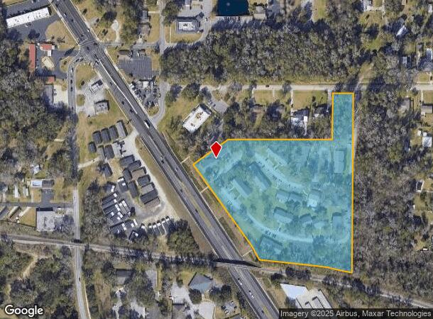
2401 Se 5Th Cir
Ocala, FL
Gilliam Sub
30273-001-00
SEC 29 TWP 15 RGE 22 THAT PT OF LOT 37 AND THE S 181 FT OF LOT 38 OF GILLIAM SUB AS RECORDED IN PLAT BK A PG 22 LYING N OF THE SEABOARD COASTLINE RR ROW & E OF PINE ST (US HWY 441) & THE E 100 FT OF S 221 FT OF N 281 FT OF LOT 38 EXC BEGIN AT THE SW
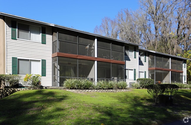
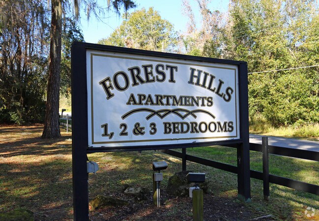
Apartment
Marion
X
Florida
12083C0517E
37,38
2025
9.02 AC
2025
Southeast Ocala
002303
Ocala
89,930 SF
DEMOGRAPHICS near 2401 Se 5Th Cir
1 Mile
3 Mile
5 Mile
2024 Total Population
5,567
42,703
95,216
2029 Population
6,273
48,203
107,202
Pop Growth 2024-2029
+ 12.68%
+ 12.88%
+ 12.59%
Average Age
44
40
40
2024 Total Households
2,305
17,579
38,020
HH Growth 2024-2029
+ 12.84%
+ 12.91%
+ 12.60%
Median Household Inc
$51,215
$49,866
$55,764
Avg Household Size
2.20
2.30
2.40
2024 Avg HH Vehicles
2.00
2.00
2.00
Median Home Value
$182,706
$230,194
$203,563
Median Year Built
1979
1980
1983
Nearby Places
Map Layers
Map Styles
 Street
 Aerial
- Restaurants
- Banks
- Shops
- Fitness
- Groceries
Nearby Properties
Address
Land Use
TOTAL SIZE
Lot Size
Zoning
Address
Land Use
TOTAL SIZE
Lot Size
Zoning
207,950 SF
14.08 AC
INST
Address
Land Use
TOTAL SIZE
Lot Size
Zoning
331,687 SF
11.66 AC
INST
Address
Land Use
TOTAL SIZE
Lot Size
Zoning
446,764 SF
138.06 AC
GU
Address
Land Use
TOTAL SIZE
Lot Size
Zoning
189,025 SF
35.42 AC
PD08
Address
Land Use
TOTAL SIZE
Lot Size
Zoning
195,992 SF
5.72 AC
FBC
Address
Land Use
TOTAL SIZE
Lot Size
Zoning
422,264 SF
40.87 AC
SC
Address
Land Use
TOTAL SIZE
Lot Size
Zoning
154,675 SF
23.62 AC
PD09
Address
Land Use
TOTAL SIZE
Lot Size
Zoning
178,015 SF
18.28 AC
PD07
Address
Land Use
TOTAL SIZE
Lot Size
Zoning
111,644 SF
19 AC
PD09
Address
Land Use
TOTAL SIZE
Lot Size
Zoning
222,210 SF
22.14 AC
SC
Address
Land Use
TOTAL SIZE
Lot Size
Zoning
92,049 SF
15.75 AC
R3
Address
Land Use
TOTAL SIZE
Lot Size
Zoning
65,570 SF
18.96 AC
PD
Address
Land Use
TOTAL SIZE
Lot Size
Zoning
110,226 SF
19.56 AC
PD09
Address
Land Use
TOTAL SIZE
Lot Size
Zoning
60,816 SF
13.67 AC
PD
Address
Land Use
TOTAL SIZE
Lot Size
Zoning
266,503 SF
25.48 AC
SC
Address
Land Use
TOTAL SIZE
Lot Size
Zoning
604,920 SF
42.92 AC
M1
Address
Land Use
TOTAL SIZE
Lot Size
Zoning
88,462 SF
31.76 AC
INST
Address
Land Use
TOTAL SIZE
Lot Size
Zoning
89,719 SF
15.16 AC
PD12
Address
Land Use
TOTAL SIZE
Lot Size
Zoning
80,532 SF
53.56 AC
INST
Address
Land Use
TOTAL SIZE
Lot Size
Zoning
76,062 SF
23.73 AC
B4
Address
Land Use
TOTAL SIZE
Lot Size
Zoning
482,618 SF
34.54 AC
M2
Address
Land Use
TOTAL SIZE
Lot Size
Zoning
30,274 SF
3.94 AC
FBC
Address
Land Use
TOTAL SIZE
Lot Size
Zoning
56,484 SF
12.50 AC
PD14
Address
Land Use
TOTAL SIZE
Lot Size
Zoning
234,097 SF
22.89 AC
SC
Address
Land Use
TOTAL SIZE
Lot Size
Zoning
65,882 SF
13.34 AC
R3
Address
Land Use
TOTAL SIZE
Lot Size
Zoning
111,395 SF
13 AC
B2
Address
Land Use
TOTAL SIZE
Lot Size
Zoning
180,334 SF
24.29 AC
INST
Address
Land Use
TOTAL SIZE
Lot Size
Zoning
101,892 SF
16.81 AC
INST
Address
Land Use
TOTAL SIZE
Lot Size
Zoning
95,552 SF
11.31 AC
SC
Address
Land Use
TOTAL SIZE
Lot Size
Zoning
69,607 SF
6.74 AC
INST
The World's #1 Commercial Real Estate Marketplace
Connect with us
© 2026 CoStar Group
The information above has been obtained from sources believed reliable. While we do not doubt its accuracy we have not verified it and make no guarantee, warranty or representation about it. It is your responsibility to independently confirm its accuracy and completeness. Any projections, opinions, assumptions, or estimates used are for example only and do not represent the current or future performance of the property. The value of this transaction to you depends on tax and other factors which should be evaluated by your tax, financial, and legal advisors. You and your advisors should conduct a careful, independent investigation of the property to determine to your satisfaction the suitability of the property for your needs.