Property Record
2401 State Highway 10, Johnstown, NY 12095


NEARBY LISTINGS FOR SALE OR LEASE
-
-
View all Johnstown listings for sale on LoopNet.com
Property Detail
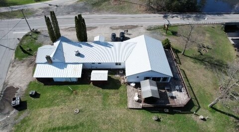
2401 State Highway 10
Gloversville, NY
OUTLET OLD PARCEL =05-01- 403.00
172400-082-016-0003-001-000-0000
Fulton
Restaurantbuilding
New York
2025
1.000
2024
0.49 AC
970400
Fulton County
4,418 SF
Albany/Schenectady/Troy
DEMOGRAPHICS near 2401 State Highway 10
1 Mile
3 Mile
5 Mile
2024 Total Population
320
1,215
2,274
2029 Population
325
1,225
2,301
Pop Growth 2024-2029
+ 1.56%
+ 0.82%
+ 1.19%
Average Age
50
49
48
2024 Total Households
139
539
1,014
HH Growth 2024-2029
+ 1.44%
+ 0.74%
+ 1.08%
Median Household Inc
$51,667
$51,081
$58,676
Avg Household Size
2.20
2.20
2.20
2024 Avg HH Vehicles
2.00
2.00
2.00
Median Home Value
$141,025
$146,099
$150,161
Median Year Built
1948
1949
1959
Nearby Places
Map Layers
Map Styles
 Street
 Aerial
- Restaurants
- Banks
- Shops
- Fitness
- Groceries
SALE & LEASE HISTORY
LISTING DATE
SALE/LEASE

May 09, 2024
For Sale
Mar 31, 2023
For Sale
Aug 18, 2021
For Sale
Nearby Properties
Address
Land Use
TOTAL SIZE
Lot Size
Zoning
Address
Land Use
TOTAL SIZE
Lot Size
Zoning
20 AC
05 - COMME
Address
Land Use
TOTAL SIZE
Lot Size
Zoning
Address
Land Use
TOTAL SIZE
Lot Size
Zoning
37,052 SF
1.70 AC
C
Address
Land Use
TOTAL SIZE
Lot Size
Zoning
10,320 SF
55.40 AC
HC
Address
Land Use
TOTAL SIZE
Lot Size
Zoning
8,400 SF
2.20 AC
Address
Land Use
TOTAL SIZE
Lot Size
Zoning
18,970 SF
0.18 AC
HC
Address
Land Use
TOTAL SIZE
Lot Size
Zoning
1,150.93 AC
WF
Address
Land Use
TOTAL SIZE
Lot Size
Zoning
646.88 AC
WF
Address
Land Use
TOTAL SIZE
Lot Size
Zoning
981 AC
OD
Address
Land Use
TOTAL SIZE
Lot Size
Zoning
3,673 SF
1.48 AC
LF-2.5
Address
Land Use
TOTAL SIZE
Lot Size
Zoning
3,630 SF
1.40 AC
02 - SINGL
Address
Land Use
TOTAL SIZE
Lot Size
Zoning
681 AC
WF
Address
Land Use
TOTAL SIZE
Lot Size
Zoning
1,456 SF
1.08 AC
H
Address
Land Use
TOTAL SIZE
Lot Size
Zoning
938.48 AC
NYS LAND
Address
Land Use
TOTAL SIZE
Lot Size
Zoning
Address
Land Use
TOTAL SIZE
Lot Size
Zoning
2,300 SF
1.60 AC
02 - SINGL
Address
Land Use
TOTAL SIZE
Lot Size
Zoning
45.95 AC
NYS LAND
Address
Land Use
TOTAL SIZE
Lot Size
Zoning
1,400 SF
1.31 AC
LF-2.5
Address
Land Use
TOTAL SIZE
Lot Size
Zoning
2,701 SF
1.31 AC
02 - SINGL
Address
Land Use
TOTAL SIZE
Lot Size
Zoning
4,776 SF
39.20 AC
01 - NOT Z
Address
Land Use
TOTAL SIZE
Lot Size
Zoning
1,680 SF
6.72 AC
03 - MULTI
Address
Land Use
TOTAL SIZE
Lot Size
Zoning
4,512 SF
0.86 AC
HC
Address
Land Use
TOTAL SIZE
Lot Size
Zoning
6,772 SF
1.40 AC
LFA
Address
Land Use
TOTAL SIZE
Lot Size
Zoning
1,248 SF
1.50 AC
LFA
Address
Land Use
TOTAL SIZE
Lot Size
Zoning
16,416 SF
1.60 AC
H
Address
Land Use
TOTAL SIZE
Lot Size
Zoning
10,610 SF
11.87 AC
LF-2.5
Address
Land Use
TOTAL SIZE
Lot Size
Zoning
6,372 SF
1.50 AC
HC
Address
Land Use
TOTAL SIZE
Lot Size
Zoning
6,160 SF
1.10 AC
LF-2.5
Address
Land Use
TOTAL SIZE
Lot Size
Zoning
1,792 SF
0.79 AC
LF
The World's #1 Commercial Real Estate Marketplace
Connect with us
© 2026 CoStar Group
The information above has been obtained from sources believed reliable. While we do not doubt its accuracy we have not verified it and make no guarantee, warranty or representation about it. It is your responsibility to independently confirm its accuracy and completeness. Any projections, opinions, assumptions, or estimates used are for example only and do not represent the current or future performance of the property. The value of this transaction to you depends on tax and other factors which should be evaluated by your tax, financial, and legal advisors. You and your advisors should conduct a careful, independent investigation of the property to determine to your satisfaction the suitability of the property for your needs.