Property Record
2401 W Main St, Belleville, IL 62226
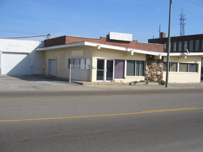


Property Detail
2401 W Main St
St. Louis, MO-IL
KLOESS 3RD ADD LOT/SEC-23 LOTS 23 & 24 & LOT 5 TWNSP HIGH SCHOOL PL A02716868
08-20.0-214-010
Saint Clair
Taxexempt
Illinois
0
5,23
2024
0.51 AC
501606
Illinois
7,464 SF
St. Louis
NEARBY LISTINGS FOR SALE OR LEASE
DEMOGRAPHICS near 2401 W Main St
1 mile
3 mile
5 mile
2025 Total Population
8,390
49,785
91,485
2030 Population
8,297
48,710
89,243
Pop Growth 2025-2030
(1.11%)
(2.16%)
(2.45%)
Average Age
41
42
42
2025 Total Households
3,598
21,543
38,909
HH Growth 2025-2030
(1.20%)
(2.18%)
(2.46%)
Median Household Inc
$51,788
$58,762
$69,290
Avg Household Size
2.20
2.20
2.30
2025 Avg HH Vehicles
2.00
2.00
2.00
Median Home Value
$123,858
$153,438
$174,374
Median Year Built
1952
1964
1973
Nearby Places
Map Layers
Map Styles
 Street
 Aerial
Layers
 Traffic
 Biking
Places
Listings with unknown addresses are not visible on the map
- Restaurants
- Banks
- Shops
- Fitness
- Groceries
PUBLIC TRANSPORTATION
COMMUTER RAIL
Swansea (Lambert Airport Shiloh-Scott - St. Louis MetroLink (MetroLink))
Drive
Walk
Distance
Swansea (Lambert Airport Shiloh-Scott - St. Louis MetroLink (MetroLink))
8 min
2.9 mi
Memorial Hospital (Lambert Airport Shiloh-Scott - St. Louis MetroLink (MetroLink))
Drive
Walk
Distance
Memorial Hospital (Lambert Airport Shiloh-Scott - St. Louis MetroLink (MetroLink))
6 min
2.9 mi
AIRPORT
Scott AFB/Midamerica St Louis
Drive
Walk
Distance
Scott AFB/Midamerica St Louis
25 min
12.6 mi
St Louis Lambert International
Drive
Walk
Distance
St Louis Lambert International
42 min
26.9 mi
Nearby Properties
Address
Land Use
TOTAL SIZE
Lot Size
Zoning
Address
Land Use
TOTAL SIZE
Lot Size
Zoning
20,522 SF
6.42 AC
Address
Land Use
TOTAL SIZE
Lot Size
Zoning
41,366 SF
12.07 AC
Address
Land Use
TOTAL SIZE
Lot Size
Zoning
127,590 SF
10.53 AC
Address
Land Use
TOTAL SIZE
Lot Size
Zoning
18,734 SF
10.48 AC
Address
Land Use
TOTAL SIZE
Lot Size
Zoning
104,230 SF
11.08 AC
Address
Land Use
TOTAL SIZE
Lot Size
Zoning
Address
Land Use
TOTAL SIZE
Lot Size
Zoning
49,248 SF
2 AC
Address
Land Use
TOTAL SIZE
Lot Size
Zoning
5,656 SF
8.65 AC
Address
Land Use
TOTAL SIZE
Lot Size
Zoning
10,505 SF
20.08 AC
Address
Land Use
TOTAL SIZE
Lot Size
Zoning
6,800 SF
4.33 AC
Address
Land Use
TOTAL SIZE
Lot Size
Zoning
130,254 SF
11.44 AC
Address
Land Use
TOTAL SIZE
Lot Size
Zoning
13,546 SF
11.19 AC
Address
Land Use
TOTAL SIZE
Lot Size
Zoning
4,420 SF
3.82 AC
Address
Land Use
TOTAL SIZE
Lot Size
Zoning
15,839 SF
5.96 AC
Address
Land Use
TOTAL SIZE
Lot Size
Zoning
7,344 SF
3.50 AC
Address
Land Use
TOTAL SIZE
Lot Size
Zoning
26,233 SF
17.61 AC
Address
Land Use
TOTAL SIZE
Lot Size
Zoning
90,945 SF
5.93 AC
Address
Land Use
TOTAL SIZE
Lot Size
Zoning
16,549 SF
5.44 AC
Address
Land Use
TOTAL SIZE
Lot Size
Zoning
54,179 SF
9.26 AC
Address
Land Use
TOTAL SIZE
Lot Size
Zoning
8,376 SF
3.11 AC
Address
Land Use
TOTAL SIZE
Lot Size
Zoning
4.70 AC
Address
Land Use
TOTAL SIZE
Lot Size
Zoning
4,818 SF
3.64 AC
Address
Land Use
TOTAL SIZE
Lot Size
Zoning
15,480 SF
1.35 AC
Address
Land Use
TOTAL SIZE
Lot Size
Zoning
23,951 SF
0.89 AC
Address
Land Use
TOTAL SIZE
Lot Size
Zoning
4,400 SF
2.56 AC
Address
Land Use
TOTAL SIZE
Lot Size
Zoning
8,208 SF
1.58 AC
Address
Land Use
TOTAL SIZE
Lot Size
Zoning
38,259 SF
7.80 AC
Address
Land Use
TOTAL SIZE
Lot Size
Zoning
12,010 SF
2.49 AC
Address
Land Use
TOTAL SIZE
Lot Size
Zoning
47,369 SF
4.17 AC
Address
Land Use
TOTAL SIZE
Lot Size
Zoning
12.99 AC
The World's #1 Commercial Real Estate Marketplace
Connect with us
© 2026 CoStar Group
The information above has been obtained from sources believed reliable. While we do not doubt its accuracy we have not verified it and make no guarantee, warranty or representation about it. It is your responsibility to independently confirm its accuracy and completeness. Any projections, opinions, assumptions, or estimates used are for example only and do not represent the current or future performance of the property. The value of this transaction to you depends on tax and other factors which should be evaluated by your tax, financial, and legal advisors. You and your advisors should conduct a careful, independent investigation of the property to determine to your satisfaction the suitability of the property for your needs.