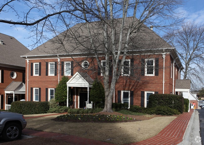
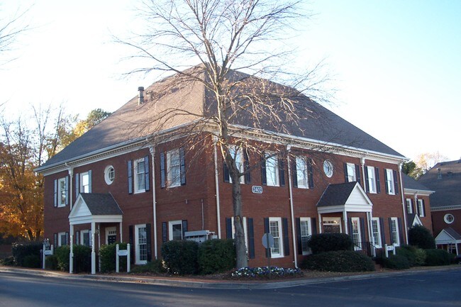
Property Record
2402 Mount Vernon Rd, Atlanta, GA 30338


Current Lease Availabilities
NEARBY LISTINGS FOR SALE OR LEASE
Property Detail
2402 Mount Vernon Rd
Atlanta-Sandy Springs-Roswell, GA
Mount Vernon Commons
18-373-14-005
UNIT 2402 29-APR-05 .08AC MOUNT VERNON COMMONS 23 X 4 X 8 X 4 X 23 X... TRACT 29-APR-05 .08AC 23 X 4 X 8 X 4 X 23 X...
Officecondo
DeKalb
X
Georgia
13089C0010K
373
2025
0.09 AC
2025
Central Perimeter
021228
Atlanta
7,480 SF
DEMOGRAPHICS near 2402 Mount Vernon Rd
1 Mile
3 Mile
5 Mile
2024 Total Population
6,708
90,308
238,547
2029 Population
6,604
90,652
241,649
Pop Growth 2024-2029
(1.55%)
+ 0.38%
+ 1.30%
Average Age
46
39
38
2024 Total Households
2,480
37,429
101,311
HH Growth 2024-2029
(1.49%)
+ 0.43%
+ 1.40%
Median Household Inc
$192,569
$95,803
$88,230
Avg Household Size
2.60
2.40
2.30
2024 Avg HH Vehicles
2.00
2.00
2.00
Median Home Value
$636,972
$531,343
$465,414
Median Year Built
1978
1985
1986
Nearby Places
Map Layers
Map Styles
 Street
 Aerial
- Restaurants
- Banks
- Shops
- Fitness
- Groceries
PUBLIC TRANSPORTATION
AIRPORT
Hartsfield - Jackson Atlanta International
DRIVE
WALK
Distance
Hartsfield - Jackson Atlanta International
43 min
27.4 mi
Nearby Properties
Address
Land Use
TOTAL SIZE
Lot Size
Zoning
Address
Land Use
TOTAL SIZE
Lot Size
Zoning
409,493 SF
10.01 AC
OI
Address
Land Use
TOTAL SIZE
Lot Size
Zoning
519,706 SF
6.70 AC
X
Address
Land Use
TOTAL SIZE
Lot Size
Zoning
296,627 SF
9.21 AC
X
Address
Land Use
TOTAL SIZE
Lot Size
Zoning
542,845 SF
10.58 AC
X
Address
Land Use
TOTAL SIZE
Lot Size
Zoning
295,885 SF
3.50 AC
X
Address
Land Use
TOTAL SIZE
Lot Size
Zoning
258,909 SF
19.01 AC
X
Address
Land Use
TOTAL SIZE
Lot Size
Zoning
103,056 SF
8.66 AC
OI
Address
Land Use
TOTAL SIZE
Lot Size
Zoning
204,376 SF
14.23 AC
X
Address
Land Use
TOTAL SIZE
Lot Size
Zoning
106,770 SF
3.13 AC
X
Address
Land Use
TOTAL SIZE
Lot Size
Zoning
366,276 SF
11.54 AC
RM-HD
Address
Land Use
TOTAL SIZE
Lot Size
Zoning
347,179 SF
18.24 AC
X
Address
Land Use
TOTAL SIZE
Lot Size
Zoning
316,391 SF
11.73 AC
OCR
Address
Land Use
TOTAL SIZE
Lot Size
Zoning
275,745 SF
12.52 AC
OCR
Address
Land Use
TOTAL SIZE
Lot Size
Zoning
227,764 SF
5.49 AC
OI
Address
Land Use
TOTAL SIZE
Lot Size
Zoning
292,537 SF
10.50 AC
ACOND
Address
Land Use
TOTAL SIZE
Lot Size
Zoning
358,622 SF
31.01 AC
RM13
Address
Land Use
TOTAL SIZE
Lot Size
Zoning
204,012 SF
6.89 AC
X
Address
Land Use
TOTAL SIZE
Lot Size
Zoning
234,474 SF
7 AC
X
Address
Land Use
TOTAL SIZE
Lot Size
Zoning
225,680 SF
17.40 AC
X
Address
Land Use
TOTAL SIZE
Lot Size
Zoning
226,026 SF
3.98 AC
OI
Address
Land Use
TOTAL SIZE
Lot Size
Zoning
1,423,656 SF
15.44 AC
OI
Address
Land Use
TOTAL SIZE
Lot Size
Zoning
142,615 SF
15.42 AC
X
Address
Land Use
TOTAL SIZE
Lot Size
Zoning
234,555 SF
12.18 AC
RM-HD
Address
Land Use
TOTAL SIZE
Lot Size
Zoning
350,038 SF
25.05 AC
X
Address
Land Use
TOTAL SIZE
Lot Size
Zoning
535,722 SF
10 AC
OI
Address
Land Use
TOTAL SIZE
Lot Size
Zoning
253,442 SF
4.98 AC
OI
Address
Land Use
TOTAL SIZE
Lot Size
Zoning
211,544 SF
5.80 AC
RM75
Address
Land Use
TOTAL SIZE
Lot Size
Zoning
132,350 SF
6.06 AC
OI: OFFICE
Address
Land Use
TOTAL SIZE
Lot Size
Zoning
249,766 SF
25.34 AC
RM100
Address
Land Use
TOTAL SIZE
Lot Size
Zoning
229,415 SF
10.41 AC
RM-HD
The World's #1 Commercial Real Estate Marketplace
Connect with us
© 2026 CoStar Group
The information above has been obtained from sources believed reliable. While we do not doubt its accuracy we have not verified it and make no guarantee, warranty or representation about it. It is your responsibility to independently confirm its accuracy and completeness. Any projections, opinions, assumptions, or estimates used are for example only and do not represent the current or future performance of the property. The value of this transaction to you depends on tax and other factors which should be evaluated by your tax, financial, and legal advisors. You and your advisors should conduct a careful, independent investigation of the property to determine to your satisfaction the suitability of the property for your needs.