Property Record
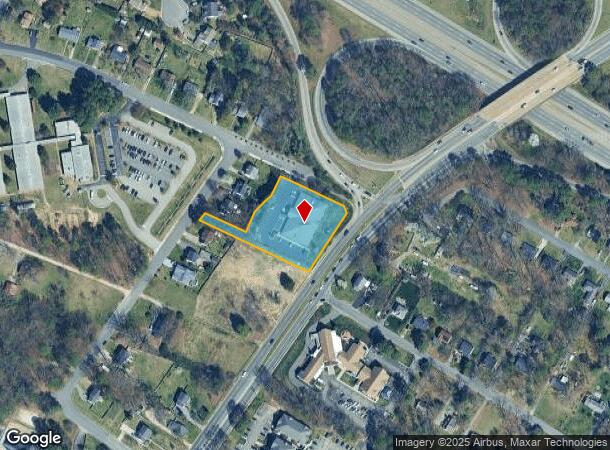
2404 N Parham Rd, Henrico, VA 23229
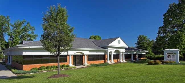
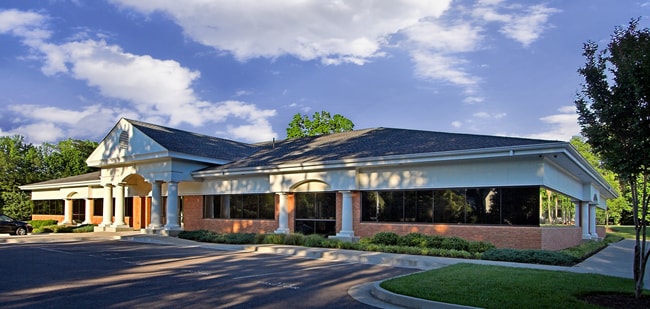
This Property Is For Sale
NEARBY LISTINGS FOR SALE OR LEASE
Property Detail
2404 N Parham Rd
756-751-2085
00690A0000 0005; N PARHAM RD AC 1.319 85 A2 1
Officebuilding
Henrico
X
Virginia
5101290010E
1.32 AC
2025
Parham South
2025
Richmond VA
200201
Richmond, VA
11,815 SF
DEMOGRAPHICS near 2404 N Parham Rd
1 Mile
3 Mile
5 Mile
2024 Total Population
14,336
100,798
214,723
2029 Population
14,300
100,325
214,509
Pop Growth 2024-2029
(0.25%)
(0.47%)
(0.10%)
Average Age
38
40
40
2024 Total Households
6,317
42,031
86,203
HH Growth 2024-2029
(0.38%)
(0.49%)
(0.09%)
Median Household Inc
$70,101
$78,939
$92,385
Avg Household Size
2.10
2.30
2.40
2024 Avg HH Vehicles
2.00
2.00
2.00
Median Home Value
$280,101
$325,763
$365,950
Median Year Built
1981
1981
1983
Nearby Places
Map Layers
Map Styles
 Street
 Aerial
- Restaurants
- Banks
- Shops
- Fitness
- Groceries
PUBLIC TRANSPORTATION
COMMUTER RAIL
DRIVE
WALK
Distance
10 min
4.7 mi
AIRPORT
Richmond International
DRIVE
WALK
Distance
Richmond International
30 min
18.9 mi
Nearby Properties
Address
Land Use
TOTAL SIZE
Lot Size
Zoning
Address
Land Use
TOTAL SIZE
Lot Size
Zoning
172,000 SF
48.58 AC
R-3
Address
Land Use
TOTAL SIZE
Lot Size
Zoning
632,549 SF
90.12 AC
R-6
Address
Land Use
TOTAL SIZE
Lot Size
Zoning
585,792 SF
38.94 AC
R-5
Address
Land Use
TOTAL SIZE
Lot Size
Zoning
597,042 SF
41.03 AC
R-6C
Address
Land Use
TOTAL SIZE
Lot Size
Zoning
568,334 SF
26.13 AC
MIXE
Address
Land Use
TOTAL SIZE
Lot Size
Zoning
173,400 SF
42 AC
MIXE
Address
Land Use
TOTAL SIZE
Lot Size
Zoning
527,410 SF
40.70 AC
A-1
Address
Land Use
TOTAL SIZE
Lot Size
Zoning
417,042 SF
49.96 AC
O-3C
Address
Land Use
TOTAL SIZE
Lot Size
Zoning
252,912 SF
28.54 AC
R-6
Address
Land Use
TOTAL SIZE
Lot Size
Zoning
184,760 SF
51.60 AC
A-1
Address
Land Use
TOTAL SIZE
Lot Size
Zoning
309,500 SF
29.78 AC
MIXE
Address
Land Use
TOTAL SIZE
Lot Size
Zoning
344,965 SF
28.33 AC
MIXE
Address
Land Use
TOTAL SIZE
Lot Size
Zoning
271,060 SF
18.31 AC
R-6
Address
Land Use
TOTAL SIZE
Lot Size
Zoning
268,461 SF
17.09 AC
R-5
Address
Land Use
TOTAL SIZE
Lot Size
Zoning
311,196 SF
27.62 AC
R-5
Address
Land Use
TOTAL SIZE
Lot Size
Zoning
306,040 SF
32.24 AC
R-5
Address
Land Use
TOTAL SIZE
Lot Size
Zoning
2.51 AC
UMUC
Address
Land Use
TOTAL SIZE
Lot Size
Zoning
250,146 SF
20.41 AC
R-5
Address
Land Use
TOTAL SIZE
Lot Size
Zoning
224,768 SF
18.08 AC
R-6
Address
Land Use
TOTAL SIZE
Lot Size
Zoning
296,784 SF
23.11 AC
R-5
Address
Land Use
TOTAL SIZE
Lot Size
Zoning
182,188 SF
21.84 AC
R-5
Address
Land Use
TOTAL SIZE
Lot Size
Zoning
257,130 SF
33.65 AC
B-3
Address
Land Use
TOTAL SIZE
Lot Size
Zoning
159,980 SF
21.38 AC
R-5C
Address
Land Use
TOTAL SIZE
Lot Size
Zoning
5.43 AC
UMUC
Address
Land Use
TOTAL SIZE
Lot Size
Zoning
7.98 AC
UMUC
Address
Land Use
TOTAL SIZE
Lot Size
Zoning
500,400 SF
31.15 AC
R-5
Address
Land Use
TOTAL SIZE
Lot Size
Zoning
232,368 SF
26.11 AC
R-5
Address
Land Use
TOTAL SIZE
Lot Size
Zoning
243,357 SF
32.34 AC
MIXE
Address
Land Use
TOTAL SIZE
Lot Size
Zoning
182,264 SF
15.91 AC
R-5
Address
Land Use
TOTAL SIZE
Lot Size
Zoning
227,905 SF
58.94 AC
R-3
The World's #1 Commercial Real Estate Marketplace
Connect with us
© 2026 CoStar Group
The information above has been obtained from sources believed reliable. While we do not doubt its accuracy we have not verified it and make no guarantee, warranty or representation about it. It is your responsibility to independently confirm its accuracy and completeness. Any projections, opinions, assumptions, or estimates used are for example only and do not represent the current or future performance of the property. The value of this transaction to you depends on tax and other factors which should be evaluated by your tax, financial, and legal advisors. You and your advisors should conduct a careful, independent investigation of the property to determine to your satisfaction the suitability of the property for your needs.