Property Record
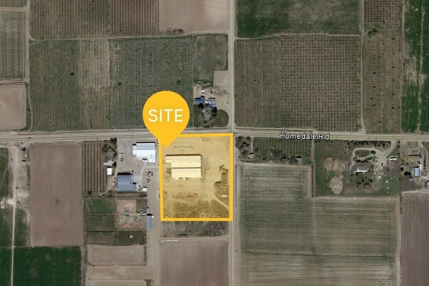
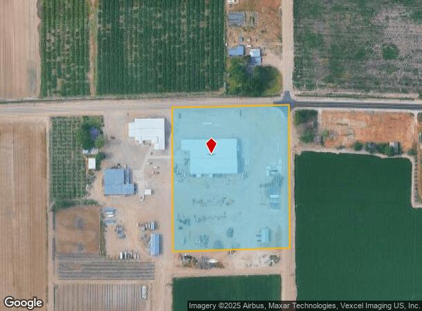
16911 Allendale Rd, Wilder, ID 83676
NEARBY LISTINGS FOR SALE OR LEASE
-
-
View all Wilder listings for sale on LoopNet.com
Property Detail
16911 Allendale Rd
3374500000
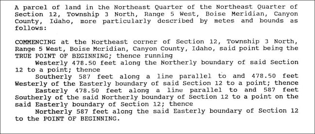
12-3N-5W NE N 587 OF TAX 3 IN NE 1/4 T78757
Miscellaneous
Canyon
X
Idaho
16027C0350F
6.44 AC
2024
North Canyon County
2025
Boise City/Nampa
022200
Boise City, ID
29,269 SF
DEMOGRAPHICS near 16911 Allendale Rd
1 Mile
3 Mile
5 Mile
2024 Total Population
272
3,469
13,563
2029 Population
334
4,201
16,288
Pop Growth 2024-2029
+ 22.79%
+ 21.10%
+ 20.09%
Average Age
41
41
39
2024 Total Households
90
1,172
4,626
HH Growth 2024-2029
+ 22.22%
+ 21.33%
+ 20.38%
Median Household Inc
$91,964
$80,491
$65,089
Avg Household Size
3.00
2.90
2.90
2024 Avg HH Vehicles
3.00
3.00
3.00
Median Home Value
$452,173
$439,834
$377,670
Median Year Built
1990
1991
1985
Nearby Places
Map Layers
Map Styles
 Street
 Aerial
- Restaurants
- Banks
- Shops
- Fitness
- Groceries
SALE & LEASE HISTORY
LISTING DATE
SALE/LEASE

Sep 24, 2016
For Sale
Nearby Properties
Address
Land Use
TOTAL SIZE
Lot Size
Zoning
Address
Land Use
TOTAL SIZE
Lot Size
Zoning
16.89 AC
M1
Address
Land Use
TOTAL SIZE
Lot Size
Zoning
98.48 AC
Address
Land Use
TOTAL SIZE
Lot Size
Zoning
25,689 SF
7.02 AC
Multi-use
Address
Land Use
TOTAL SIZE
Lot Size
Zoning
600 SF
30.90 AC
Multi-use
Address
Land Use
TOTAL SIZE
Lot Size
Zoning
10.94 AC
Address
Land Use
TOTAL SIZE
Lot Size
Zoning
35,778 SF
6.32 AC
C2
Address
Land Use
TOTAL SIZE
Lot Size
Zoning
7.81 AC
Address
Land Use
TOTAL SIZE
Lot Size
Zoning
48,000 SF
19.77 AC
Residentia
Address
Land Use
TOTAL SIZE
Lot Size
Zoning
9,585 SF
4.34 AC
RR
Address
Land Use
TOTAL SIZE
Lot Size
Zoning
9.34 AC
Address
Land Use
TOTAL SIZE
Lot Size
Zoning
2.21 AC
Address
Land Use
TOTAL SIZE
Lot Size
Zoning
57.79 AC
Address
Land Use
TOTAL SIZE
Lot Size
Zoning
Address
Land Use
TOTAL SIZE
Lot Size
Zoning
6,408 SF
0.88 AC
Address
Land Use
TOTAL SIZE
Lot Size
Zoning
2.02 AC
Multi-use
Address
Land Use
TOTAL SIZE
Lot Size
Zoning
12,566 SF
3.55 AC
Residentia
Address
Land Use
TOTAL SIZE
Lot Size
Zoning
1.53 AC
RR
Address
Land Use
TOTAL SIZE
Lot Size
Zoning
5,000 SF
4.98 AC
Residentia
Address
Land Use
TOTAL SIZE
Lot Size
Zoning
15,840 SF
6.16 AC
Address
Land Use
TOTAL SIZE
Lot Size
Zoning
5,401 SF
0.46 AC
Address
Land Use
TOTAL SIZE
Lot Size
Zoning
3,224 SF
0.72 AC
Address
Land Use
TOTAL SIZE
Lot Size
Zoning
0.46 AC
Address
Land Use
TOTAL SIZE
Lot Size
Zoning
5,000 SF
5.55 AC
Multi-use
Address
Land Use
TOTAL SIZE
Lot Size
Zoning
56.91 AC
Address
Land Use
TOTAL SIZE
Lot Size
Zoning
3,761 SF
0.29 AC
Address
Land Use
TOTAL SIZE
Lot Size
Zoning
7,400 SF
0.50 AC
Address
Land Use
TOTAL SIZE
Lot Size
Zoning
3,336 SF
3.71 AC
M1
Address
Land Use
TOTAL SIZE
Lot Size
Zoning
6,565 SF
2.78 AC
Residentia
The World's #1 Commercial Real Estate Marketplace
Connect with us
© 2025 CoStar Group
The information above has been obtained from sources believed reliable. While we do not doubt its accuracy we have not verified it and make no guarantee, warranty or representation about it. It is your responsibility to independently confirm its accuracy and completeness. Any projections, opinions, assumptions, or estimates used are for example only and do not represent the current or future performance of the property. The value of this transaction to you depends on tax and other factors which should be evaluated by your tax, financial, and legal advisors. You and your advisors should conduct a careful, independent investigation of the property to determine to your satisfaction the suitability of the property for your needs.