Property Record
2405 Covered Bridge Dr, Lancaster, PA 17602
NEARBY LISTINGS FOR SALE OR LEASE
-
-
View all Lancaster listings for sale on LoopNet.com
Property Detail
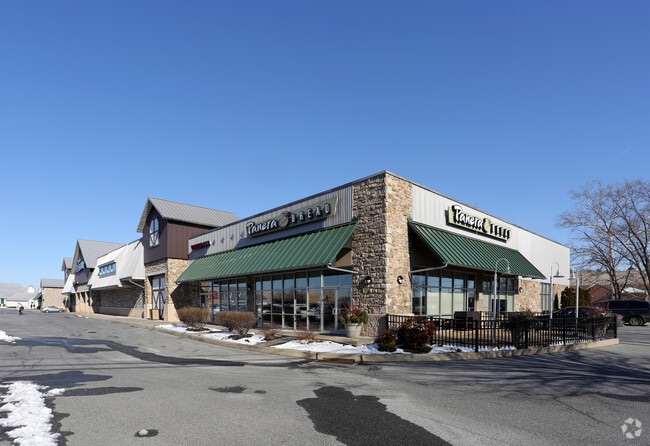
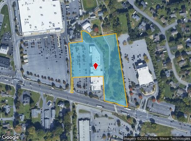
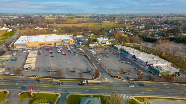
2405 Covered Bridge Dr
310-74222-1-0004
Covered Bridge Marketplace
Commercialcondominium
2405 COVERED BRIDGE DR
A
Lancaster
42071C0389F
Pennsylvania
2024
5.23 AC
2025
Lancaster County
013204
Philadelphia
39,670 SF
Lancaster, PA
DEMOGRAPHICS near 2405 Covered Bridge Dr
1 Mile
3 Mile
5 Mile
2024 Total Population
1,439
19,335
62,828
2029 Population
1,429
19,329
62,954
Pop Growth 2024-2029
(0.69%)
(0.03%)
+ 0.20%
Average Age
40
39
41
2024 Total Households
490
7,047
23,000
HH Growth 2024-2029
(0.82%)
(0.01%)
+ 0.10%
Median Household Inc
$72,661
$83,913
$78,205
Avg Household Size
2.80
2.70
2.60
2024 Avg HH Vehicles
2.00
2.00
2.00
Median Home Value
$298,506
$309,465
$274,988
Median Year Built
1979
1983
1976
Nearby Places
Map Layers
Map Styles
 Street
 Aerial
- Restaurants
- Banks
- Shops
- Fitness
- Groceries
PUBLIC TRANSPORTATION
COMMUTER RAIL
DRIVE
WALK
Distance
14 min
8.1 mi
AIRPORT
Harrisburg International
DRIVE
WALK
Distance
Harrisburg International
50 min
37.5 mi
Freight Ports
Port Newark Container Terminal
DRIVE
WALK
Distance
Port Newark Container Terminal
77 min
43.1 mi
SALE & LEASE HISTORY
LISTING DATE
SALE/LEASE

Sep 25, 2016
For Lease
May 01, 2017
For Sale
Mar 23, 2017
For Lease
Jan 24, 2022
For Sale
Nearby Properties
Address
Land Use
TOTAL SIZE
Lot Size
Zoning
Address
Land Use
TOTAL SIZE
Lot Size
Zoning
403,771 SF
106.93 AC
Address
Land Use
TOTAL SIZE
Lot Size
Zoning
333,041 SF
159.39 AC
RV
Address
Land Use
TOTAL SIZE
Lot Size
Zoning
610,108 SF
39.96 AC
C-2
Address
Land Use
TOTAL SIZE
Lot Size
Zoning
322,380 SF
33.29 AC
R-3
Address
Land Use
TOTAL SIZE
Lot Size
Zoning
289,398 SF
35.20 AC
C-2
Address
Land Use
TOTAL SIZE
Lot Size
Zoning
323,300 SF
21.60 AC
C-2
Address
Land Use
TOTAL SIZE
Lot Size
Zoning
221,609 SF
62.37 AC
HC
Address
Land Use
TOTAL SIZE
Lot Size
Zoning
125,153 SF
24.10 AC
Address
Land Use
TOTAL SIZE
Lot Size
Zoning
251,051 SF
31.10 AC
R-3
Address
Land Use
TOTAL SIZE
Lot Size
Zoning
19.29 AC
Address
Land Use
TOTAL SIZE
Lot Size
Zoning
258,104 SF
31.40 AC
I
Address
Land Use
TOTAL SIZE
Lot Size
Zoning
172,408 SF
13.70 AC
R-3
Address
Land Use
TOTAL SIZE
Lot Size
Zoning
70,314 SF
3.20 AC
C-2
Address
Land Use
TOTAL SIZE
Lot Size
Zoning
156,140 SF
23.50 AC
RV
Address
Land Use
TOTAL SIZE
Lot Size
Zoning
71,600 SF
15.20 AC
C-2
Address
Land Use
TOTAL SIZE
Lot Size
Zoning
142,393 SF
22 AC
I
Address
Land Use
TOTAL SIZE
Lot Size
Zoning
36,494 SF
7 AC
R-2
Address
Land Use
TOTAL SIZE
Lot Size
Zoning
82,718 SF
7.85 AC
I
Address
Land Use
TOTAL SIZE
Lot Size
Zoning
116,308 SF
12.30 AC
R-3
Address
Land Use
TOTAL SIZE
Lot Size
Zoning
51,824 SF
2.33 AC
Address
Land Use
TOTAL SIZE
Lot Size
Zoning
200,027 SF
27.80 AC
C-2
Address
Land Use
TOTAL SIZE
Lot Size
Zoning
298,472 SF
160.06 AC
R
Address
Land Use
TOTAL SIZE
Lot Size
Zoning
123,614 SF
8.99 AC
C-2
Address
Land Use
TOTAL SIZE
Lot Size
Zoning
42,754 SF
1.92 AC
Address
Land Use
TOTAL SIZE
Lot Size
Zoning
53,275 SF
5.01 AC
C-2
Address
Land Use
TOTAL SIZE
Lot Size
Zoning
50,120 SF
2.60 AC
R-3
Address
Land Use
TOTAL SIZE
Lot Size
Zoning
61,006 SF
2.78 AC
C-2
Address
Land Use
TOTAL SIZE
Lot Size
Zoning
81,332 SF
8.70 AC
R-3
Address
Land Use
TOTAL SIZE
Lot Size
Zoning
100,645 SF
5.60 AC
I
Address
Land Use
TOTAL SIZE
Lot Size
Zoning
99,825 SF
6.10 AC
I
The World's #1 Commercial Real Estate Marketplace
Connect with us
© 2026 CoStar Group
The information above has been obtained from sources believed reliable. While we do not doubt its accuracy we have not verified it and make no guarantee, warranty or representation about it. It is your responsibility to independently confirm its accuracy and completeness. Any projections, opinions, assumptions, or estimates used are for example only and do not represent the current or future performance of the property. The value of this transaction to you depends on tax and other factors which should be evaluated by your tax, financial, and legal advisors. You and your advisors should conduct a careful, independent investigation of the property to determine to your satisfaction the suitability of the property for your needs.