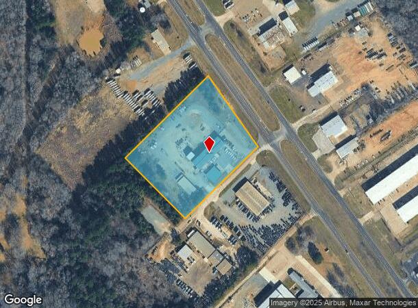
Property Record
2405 State Highway 135 N, Kilgore, TX 75662

NEARBY LISTINGS FOR SALE OR LEASE
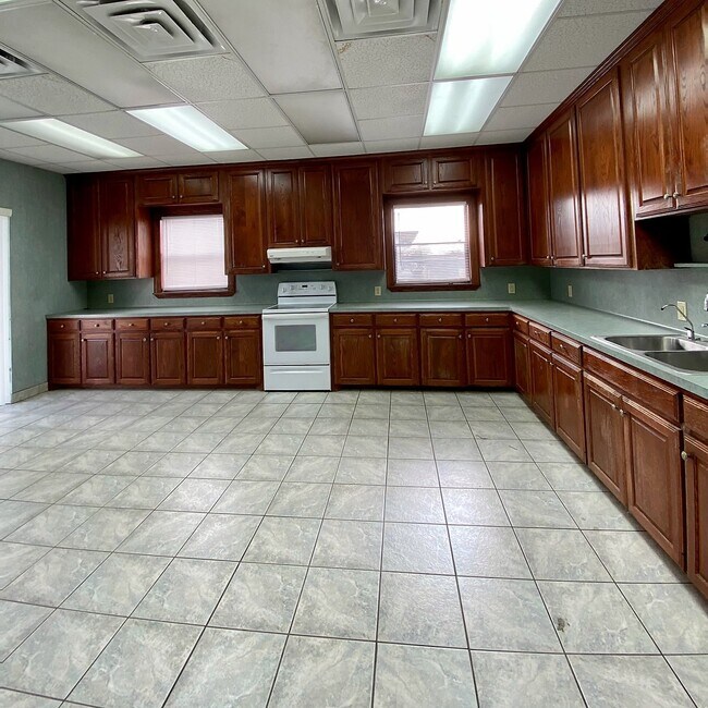
Property Detail
2405 State Highway 135 N
Longview, TX
Chism W P Sur
14173
AB 36 W P CHISM TR 332
Industrialgeneral
Gregg
X
Texas
48183C0145F
332
2024
5.01 AC
2025
Tyler & Longview
010401
Other Market Areas
9,000 SF
DEMOGRAPHICS near 2405 State Highway 135 N
1 Mile
3 Mile
5 Mile
2024 Total Population
820
9,859
22,486
2029 Population
850
10,159
22,999
Pop Growth 2024-2029
+ 3.66%
+ 3.04%
+ 2.28%
Average Age
36
36
37
2024 Total Households
285
3,428
8,166
HH Growth 2024-2029
+ 3.51%
+ 3.03%
+ 2.29%
Median Household Inc
$53,125
$54,495
$62,645
Avg Household Size
2.90
2.70
2.70
2024 Avg HH Vehicles
2.00
2.00
2.00
Median Home Value
$132,051
$118,195
$160,846
Median Year Built
1987
1980
1977
Nearby Places
Map Layers
Map Styles
 Street
 Aerial
- Restaurants
- Banks
- Shops
- Fitness
- Groceries
PUBLIC TRANSPORTATION
AIRPORT
Tyler Pounds Regional
DRIVE
WALK
Distance
Tyler Pounds Regional
47 min
33.3 mi
Freight Ports
Port of Shreveport
DRIVE
WALK
Distance
Port of Shreveport
95 min
81.6 mi
SALE & LEASE HISTORY
LISTING DATE
SALE/LEASE

Sep 23, 2016
For Sale
Feb 10, 2021
For Lease
Nearby Properties
Address
Land Use
TOTAL SIZE
Lot Size
Zoning
Address
Land Use
TOTAL SIZE
Lot Size
Zoning
299,804 SF
8.35 AC
Address
Land Use
TOTAL SIZE
Lot Size
Zoning
27,138 SF
17.01 AC
Address
Land Use
TOTAL SIZE
Lot Size
Zoning
102,756 SF
7.85 AC
Address
Land Use
TOTAL SIZE
Lot Size
Zoning
140,050 SF
9.22 AC
Address
Land Use
TOTAL SIZE
Lot Size
Zoning
81,237 SF
21.09 AC
Address
Land Use
TOTAL SIZE
Lot Size
Zoning
45,665 SF
3.66 AC
Address
Land Use
TOTAL SIZE
Lot Size
Zoning
171,388 SF
18.76 AC
Address
Land Use
TOTAL SIZE
Lot Size
Zoning
13,767 SF
29.06 AC
Address
Land Use
TOTAL SIZE
Lot Size
Zoning
9,000 SF
13.05 AC
Address
Land Use
TOTAL SIZE
Lot Size
Zoning
73,477 SF
1.16 AC
Address
Land Use
TOTAL SIZE
Lot Size
Zoning
156,768 SF
3.52 AC
Address
Land Use
TOTAL SIZE
Lot Size
Zoning
54,330 SF
0.88 AC
Address
Land Use
TOTAL SIZE
Lot Size
Zoning
118,324 SF
10 AC
Address
Land Use
TOTAL SIZE
Lot Size
Zoning
53,636 SF
0.34 AC
Address
Land Use
TOTAL SIZE
Lot Size
Zoning
28,226 SF
16.18 AC
Address
Land Use
TOTAL SIZE
Lot Size
Zoning
69,823 SF
1.64 AC
Address
Land Use
TOTAL SIZE
Lot Size
Zoning
37,204 SF
2.09 AC
Address
Land Use
TOTAL SIZE
Lot Size
Zoning
46,368 SF
2 AC
Address
Land Use
TOTAL SIZE
Lot Size
Zoning
57,632 SF
8.72 AC
Address
Land Use
TOTAL SIZE
Lot Size
Zoning
52,145 SF
6.23 AC
Address
Land Use
TOTAL SIZE
Lot Size
Zoning
19,008 SF
0.80 AC
Address
Land Use
TOTAL SIZE
Lot Size
Zoning
25,969 SF
0.34 AC
Address
Land Use
TOTAL SIZE
Lot Size
Zoning
51,520 SF
3.23 AC
Address
Land Use
TOTAL SIZE
Lot Size
Zoning
462,237 SF
54.99 AC
Address
Land Use
TOTAL SIZE
Lot Size
Zoning
19,494 SF
2.65 AC
Address
Land Use
TOTAL SIZE
Lot Size
Zoning
7,533 SF
12.80 AC
Address
Land Use
TOTAL SIZE
Lot Size
Zoning
80,000 SF
12.44 AC
Address
Land Use
TOTAL SIZE
Lot Size
Zoning
28,610 SF
0.92 AC
Address
Land Use
TOTAL SIZE
Lot Size
Zoning
21,788 SF
2.48 AC
Address
Land Use
TOTAL SIZE
Lot Size
Zoning
1,285 SF
7.48 AC
The World's #1 Commercial Real Estate Marketplace
Connect with us
© 2025 CoStar Group
The information above has been obtained from sources believed reliable. While we do not doubt its accuracy we have not verified it and make no guarantee, warranty or representation about it. It is your responsibility to independently confirm its accuracy and completeness. Any projections, opinions, assumptions, or estimates used are for example only and do not represent the current or future performance of the property. The value of this transaction to you depends on tax and other factors which should be evaluated by your tax, financial, and legal advisors. You and your advisors should conduct a careful, independent investigation of the property to determine to your satisfaction the suitability of the property for your needs.