Property Record
2405 W 65Th Ave, Denver, CO 80221

NEARBY LISTINGS FOR SALE OR LEASE
Property Detail
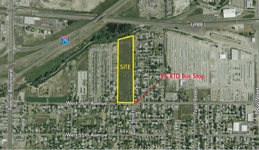
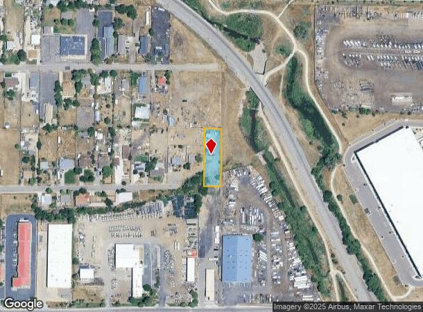
2405 W 65Th Ave
Denver-Aurora-Lakewood, CO
North Lawn Gardens
1825-05-4-06-015
SUB:NORTH LAWN GARDENS BLK:3 LOT:16
Residentialacreage
Adams
X
Colorado
08059C0209F
16
2024
0.39 AC
2024
Northwest Denver
009502
Denver
DEMOGRAPHICS near 2405 W 65Th Ave
1 Mile
3 Mile
5 Mile
2024 Total Population
8,580
123,534
409,330
2029 Population
8,875
126,399
417,490
Pop Growth 2024-2029
+ 3.44%
+ 2.32%
+ 1.99%
Average Age
38
37
38
2024 Total Households
3,135
51,595
181,390
HH Growth 2024-2029
+ 3.35%
+ 2.21%
+ 1.97%
Median Household Inc
$81,436
$84,817
$76,544
Avg Household Size
2.60
2.30
2.20
2024 Avg HH Vehicles
2.00
2.00
2.00
Median Home Value
$449,058
$497,907
$473,251
Median Year Built
1969
1968
1974
Nearby Places
Map Layers
Map Styles
 Street
 Aerial
- Restaurants
- Banks
- Shops
- Fitness
- Groceries
PUBLIC TRANSPORTATION
COMMUTER RAIL
Clear Creek - Federal Station Track 1 (Union Station to Wheat Ridge Ward Station - Regional Transportation District)
DRIVE
WALK
Distance
Clear Creek - Federal Station Track 1 (Union Station to Wheat Ridge Ward Station - Regional Transportation District)
4 min
1.4 mi
Pecos Junction Station Track 1 (Union Station to Westminster Station - Regional Transportation District, Union Station to Wheat Ridge Ward Station - Regional Transportation District)
DRIVE
WALK
Distance
Pecos Junction Station Track 1 (Union Station to Westminster Station - Regional Transportation District, Union Station to Wheat Ridge Ward Station - Regional Transportation District)
5 min
1.9 mi
AIRPORT
Denver International
DRIVE
WALK
Distance
Denver International
36 min
26.7 mi
Freight Ports
Tulsa Port Of Catoosa
DRIVE
WALK
Distance
Tulsa Port Of Catoosa
733 min
712.2 mi
SALE & LEASE HISTORY
LISTING DATE
SALE/LEASE

Aug 22, 2023
For Sale
Nearby Properties
Address
Land Use
TOTAL SIZE
Lot Size
Zoning
Address
Land Use
TOTAL SIZE
Lot Size
Zoning
860,132 SF
68.50 AC
R-5
Address
Land Use
TOTAL SIZE
Lot Size
Zoning
398,180 SF
33.31 AC
R1C
Address
Land Use
TOTAL SIZE
Lot Size
Zoning
551,915 SF
25.76 AC
Address
Land Use
TOTAL SIZE
Lot Size
Zoning
305,110 SF
16.87 AC
Address
Land Use
TOTAL SIZE
Lot Size
Zoning
470,539 SF
23.59 AC
Address
Land Use
TOTAL SIZE
Lot Size
Zoning
419,745 SF
24.75 AC
Address
Land Use
TOTAL SIZE
Lot Size
Zoning
727,307 SF
38.44 AC
I-B
Address
Land Use
TOTAL SIZE
Lot Size
Zoning
390,764 SF
20.19 AC
Address
Land Use
TOTAL SIZE
Lot Size
Zoning
290,655 SF
24.41 AC
I-B
Address
Land Use
TOTAL SIZE
Lot Size
Zoning
283,572 SF
17.76 AC
Address
Land Use
TOTAL SIZE
Lot Size
Zoning
345,752 SF
15.28 AC
I-B
Address
Land Use
TOTAL SIZE
Lot Size
Zoning
376,598 SF
19.28 AC
Address
Land Use
TOTAL SIZE
Lot Size
Zoning
6,731 SF
80.77 AC
Address
Land Use
TOTAL SIZE
Lot Size
Zoning
370,741 SF
19.53 AC
I3
Address
Land Use
TOTAL SIZE
Lot Size
Zoning
277,200 SF
16.43 AC
Address
Land Use
TOTAL SIZE
Lot Size
Zoning
350,400 SF
19.31 AC
Address
Land Use
TOTAL SIZE
Lot Size
Zoning
138,904 SF
6.25 AC
U-TU-C
Address
Land Use
TOTAL SIZE
Lot Size
Zoning
281,777 SF
24.89 AC
I2
Address
Land Use
TOTAL SIZE
Lot Size
Zoning
277,869 SF
12.76 AC
Address
Land Use
TOTAL SIZE
Lot Size
Zoning
201,025 SF
12.18 AC
Address
Land Use
TOTAL SIZE
Lot Size
Zoning
195,600 SF
11.18 AC
Address
Land Use
TOTAL SIZE
Lot Size
Zoning
147,009 SF
36.94 AC
I3
Address
Land Use
TOTAL SIZE
Lot Size
Zoning
380,836 SF
25.45 AC
R1C
Address
Land Use
TOTAL SIZE
Lot Size
Zoning
338,400 SF
33.45 AC
Address
Land Use
TOTAL SIZE
Lot Size
Zoning
182,124 SF
6.16 AC
I3
Address
Land Use
TOTAL SIZE
Lot Size
Zoning
76,078 SF
6.64 AC
U-SU-C
Address
Land Use
TOTAL SIZE
Lot Size
Zoning
176,800 SF
8.72 AC
I-MX-3
Address
Land Use
TOTAL SIZE
Lot Size
Zoning
176,800 SF
8.81 AC
I-MX-3
Address
Land Use
TOTAL SIZE
Lot Size
Zoning
177,298 SF
10.83 AC
Address
Land Use
TOTAL SIZE
Lot Size
Zoning
210,500 SF
11.14 AC
I2
The World's #1 Commercial Real Estate Marketplace
Connect with us
© 2025 CoStar Group
The information above has been obtained from sources believed reliable. While we do not doubt its accuracy we have not verified it and make no guarantee, warranty or representation about it. It is your responsibility to independently confirm its accuracy and completeness. Any projections, opinions, assumptions, or estimates used are for example only and do not represent the current or future performance of the property. The value of this transaction to you depends on tax and other factors which should be evaluated by your tax, financial, and legal advisors. You and your advisors should conduct a careful, independent investigation of the property to determine to your satisfaction the suitability of the property for your needs.