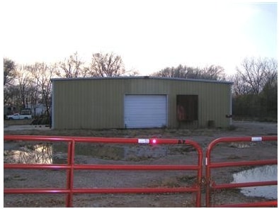
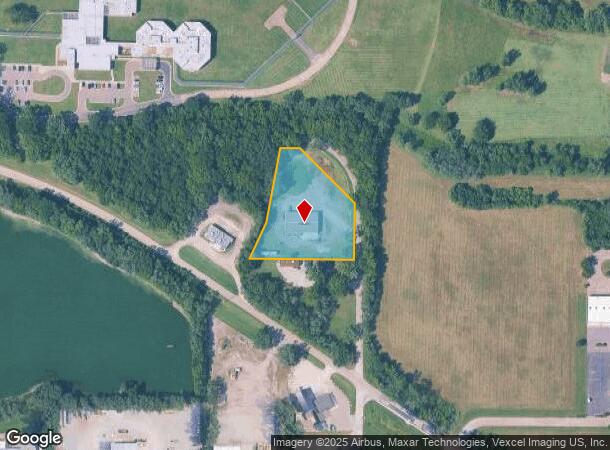
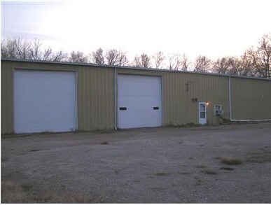
Property Record
2406 Nw Clay St, Topeka, KS 66618
NEARBY LISTINGS FOR SALE OR LEASE
Property Detail
2406 Nw Clay St
Topeka, KS
North Star
104-18-0-30-01-001-010
S18, T11, R16, PART LOT 2 BLK A BEG SE COR LOT 2 TH E 317.21 NELY 119.51 NLY 231.12 E 60.04 SE 234.65 S 172.7 TO POB
Shipyard
Shawnee
X
Kansas
20177C0206E
2
2024
1.71 AC
2025
Topeka
000700
Kansas City
6,000 SF
DEMOGRAPHICS near 2406 Nw Clay St
1 Mile
3 Mile
5 Mile
2024 Total Population
2,560
23,679
76,011
2029 Population
2,545
23,617
75,740
Pop Growth 2024-2029
(0.59%)
(0.26%)
(0.36%)
Average Age
41
40
40
2024 Total Households
1,032
9,861
31,544
HH Growth 2024-2029
(0.68%)
(0.20%)
(0.37%)
Median Household Inc
$52,980
$48,308
$47,953
Avg Household Size
2.30
2.30
2.20
2024 Avg HH Vehicles
2.00
2.00
2.00
Median Home Value
$98,982
$106,272
$109,161
Median Year Built
1972
1953
1957
Nearby Places
Map Layers
Map Styles
 Street
 Aerial
- Restaurants
- Banks
- Shops
- Fitness
- Groceries
PUBLIC TRANSPORTATION
COMMUTER RAIL
DRIVE
WALK
Distance
9 min
4.0 mi
Nearby Properties
Address
Land Use
TOTAL SIZE
Lot Size
Zoning
Address
Land Use
TOTAL SIZE
Lot Size
Zoning
309,298 SF
7.34 AC
M1
Address
Land Use
TOTAL SIZE
Lot Size
Zoning
90,929 SF
8.68 AC
PUD,OI3,I1
Address
Land Use
TOTAL SIZE
Lot Size
Zoning
98,898 SF
1.91 AC
C5
Address
Land Use
TOTAL SIZE
Lot Size
Zoning
174,115 SF
61.82 AC
RR1
Address
Land Use
TOTAL SIZE
Lot Size
Zoning
127,947 SF
7.12 AC
C5
Address
Land Use
TOTAL SIZE
Lot Size
Zoning
123,795 SF
16.45 AC
PUD,R1,I1,
Address
Land Use
TOTAL SIZE
Lot Size
Zoning
129,425 SF
96.26 AC
R1
Address
Land Use
TOTAL SIZE
Lot Size
Zoning
101,766 SF
2.39 AC
C5,I1
Address
Land Use
TOTAL SIZE
Lot Size
Zoning
32,838 SF
3.25 AC
MS1
Address
Land Use
TOTAL SIZE
Lot Size
Zoning
92,118 SF
10.87 AC
R2
Address
Land Use
TOTAL SIZE
Lot Size
Zoning
135,164 SF
11.01 AC
PUD,I1
Address
Land Use
TOTAL SIZE
Lot Size
Zoning
70,058 SF
1.03 AC
C5
Address
Land Use
TOTAL SIZE
Lot Size
Zoning
238,319 SF
170.40 AC
PUD,RR1,OI
Address
Land Use
TOTAL SIZE
Lot Size
Zoning
64,310 SF
12.95 AC
PUD,R1,I1,
Address
Land Use
TOTAL SIZE
Lot Size
Zoning
17,544 SF
42.80 AC
PUD,I1,M2,
Address
Land Use
TOTAL SIZE
Lot Size
Zoning
26,269 SF
8.18 AC
RR1
Address
Land Use
TOTAL SIZE
Lot Size
Zoning
88,401 SF
1.51 AC
C5
Address
Land Use
TOTAL SIZE
Lot Size
Zoning
16,168 SF
1.62 AC
MS1
Address
Land Use
TOTAL SIZE
Lot Size
Zoning
51,285 SF
36.63 AC
PUD,I1,M2,
Address
Land Use
TOTAL SIZE
Lot Size
Zoning
18,984 SF
0.35 AC
HL,X3
Address
Land Use
TOTAL SIZE
Lot Size
Zoning
91,840 SF
13.75 AC
PUD,I1
Address
Land Use
TOTAL SIZE
Lot Size
Zoning
20,304 SF
13.48 AC
RR1
Address
Land Use
TOTAL SIZE
Lot Size
Zoning
26,783 SF
3.11 AC
PUD,I1,M2,
Address
Land Use
TOTAL SIZE
Lot Size
Zoning
0.41 AC
OI2
Address
Land Use
TOTAL SIZE
Lot Size
Zoning
421,639 SF
30.15 AC
PUD,I1
Address
Land Use
TOTAL SIZE
Lot Size
Zoning
63,903 SF
5.05 AC
R2
Address
Land Use
TOTAL SIZE
Lot Size
Zoning
35,055 SF
109.89 AC
RR1
Address
Land Use
TOTAL SIZE
Lot Size
Zoning
35,605 SF
2.28 AC
R2
Address
Land Use
TOTAL SIZE
Lot Size
Zoning
38,125 SF
2.55 AC
C5
Address
Land Use
TOTAL SIZE
Lot Size
Zoning
67,997 SF
7.83 AC
PUD
The World's #1 Commercial Real Estate Marketplace
Connect with us
© 2025 CoStar Group
The information above has been obtained from sources believed reliable. While we do not doubt its accuracy we have not verified it and make no guarantee, warranty or representation about it. It is your responsibility to independently confirm its accuracy and completeness. Any projections, opinions, assumptions, or estimates used are for example only and do not represent the current or future performance of the property. The value of this transaction to you depends on tax and other factors which should be evaluated by your tax, financial, and legal advisors. You and your advisors should conduct a careful, independent investigation of the property to determine to your satisfaction the suitability of the property for your needs.