Property Record
2406 Weedn Blvd, Purcell, OK 73080


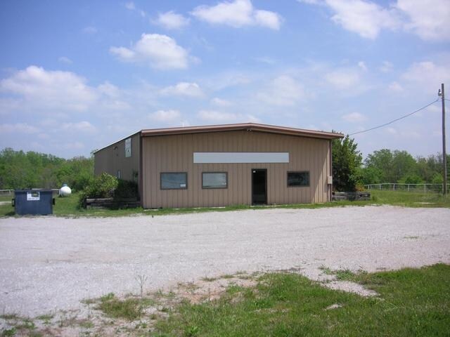
Property Detail
2406 Weedn Blvd
Oklahoma City, OK
LOTS 2-4, BLOCK 1 J ESTATES
0JES00001003000000
MCCLAIN
Restaurantbuilding
Oklahoma
B and X Area of moderate flood hazard, usually the area between the limits of the 100-year and 500-year floods.
2-4
2025
0.10 AC
2025
Outlying McClain
4003005060
Oklahoma City
4,296 SF
NEARBY LISTINGS FOR SALE OR LEASE
-
-
View all Purcell listings for sale on LoopNet.com
DEMOGRAPHICS near 2406 Weedn Blvd
1 mile
3 mile
5 mile
2025 Total Population
748
7,111
12,111
2030 Population
859
7,912
13,422
Pop Growth 2025-2030
+ 14.84%
+ 11.26%
+ 10.82%
Average Age
39
40
40
2025 Total Households
271
2,622
4,493
HH Growth 2025-2030
+ 15.13%
+ 11.40%
+ 10.95%
Median Household Inc
$61,146
$63,059
$62,702
Avg Household Size
2.60
2.60
2.60
2025 Avg HH Vehicles
3.00
2.00
2.00
Median Home Value
$69,565
$164,299
$178,666
Median Year Built
1978
1981
1983
Nearby Places
Map Layers
Map Styles
 Street
 Aerial
Layers
 Traffic
 Biking
Places
Listings with unknown addresses are not visible on the map
- Restaurants
- Banks
- Shops
- Fitness
- Groceries
PUBLIC TRANSPORTATION
COMMUTER RAIL
Drive
Walk
Distance
5 min
2.7 mi
AIRPORT
Will Rogers World
Drive
Walk
Distance
Will Rogers World
49 min
39.5 mi
Nearby Properties
Address
Land Use
TOTAL SIZE
Lot Size
Zoning
Address
Land Use
TOTAL SIZE
Lot Size
Zoning
11,976 SF
0.14 AC
Address
Land Use
TOTAL SIZE
Lot Size
Zoning
155,763 SF
16.69 AC
NP
Address
Land Use
TOTAL SIZE
Lot Size
Zoning
50,427 SF
4.07 AC
Address
Land Use
TOTAL SIZE
Lot Size
Zoning
24.70 AC
Address
Land Use
TOTAL SIZE
Lot Size
Zoning
3,200 SF
1 AC
Address
Land Use
TOTAL SIZE
Lot Size
Zoning
0.64 AC
Address
Land Use
TOTAL SIZE
Lot Size
Zoning
14,050 SF
6.39 AC
Address
Land Use
TOTAL SIZE
Lot Size
Zoning
4,700 SF
0.32 AC
Address
Land Use
TOTAL SIZE
Lot Size
Zoning
10 AC
Address
Land Use
TOTAL SIZE
Lot Size
Zoning
0.24 AC
Address
Land Use
TOTAL SIZE
Lot Size
Zoning
24,333 SF
2.94 AC
R1
Address
Land Use
TOTAL SIZE
Lot Size
Zoning
1.23 AC
R1
Address
Land Use
TOTAL SIZE
Lot Size
Zoning
14,606 SF
1.62 AC
Address
Land Use
TOTAL SIZE
Lot Size
Zoning
25,115 SF
0.21 AC
Address
Land Use
TOTAL SIZE
Lot Size
Zoning
80 AC
Address
Land Use
TOTAL SIZE
Lot Size
Zoning
3,375 SF
0.15 AC
Address
Land Use
TOTAL SIZE
Lot Size
Zoning
0.08 AC
Address
Land Use
TOTAL SIZE
Lot Size
Zoning
1,991 SF
3.50 AC
Address
Land Use
TOTAL SIZE
Lot Size
Zoning
2,805 SF
3 AC
Address
Land Use
TOTAL SIZE
Lot Size
Zoning
4,320 SF
0.17 AC
Address
Land Use
TOTAL SIZE
Lot Size
Zoning
0.32 AC
R1
Address
Land Use
TOTAL SIZE
Lot Size
Zoning
2,320 SF
0.56 AC
Address
Land Use
TOTAL SIZE
Lot Size
Zoning
72,000 SF
11.67 AC
Address
Land Use
TOTAL SIZE
Lot Size
Zoning
2,250 SF
0.19 AC
R1
Address
Land Use
TOTAL SIZE
Lot Size
Zoning
21,006 SF
1.33 AC
Address
Land Use
TOTAL SIZE
Lot Size
Zoning
24,770 SF
9.50 AC
Address
Land Use
TOTAL SIZE
Lot Size
Zoning
2,473 SF
1.91 AC
Address
Land Use
TOTAL SIZE
Lot Size
Zoning
4,713 SF
1.37 AC
The World's #1 Commercial Real Estate Marketplace
Connect with us
© 2026 CoStar Group
The information above has been obtained from sources believed reliable. While we do not doubt its accuracy we have not verified it and make no guarantee, warranty or representation about it. It is your responsibility to independently confirm its accuracy and completeness. Any projections, opinions, assumptions, or estimates used are for example only and do not represent the current or future performance of the property. The value of this transaction to you depends on tax and other factors which should be evaluated by your tax, financial, and legal advisors. You and your advisors should conduct a careful, independent investigation of the property to determine to your satisfaction the suitability of the property for your needs.