Property Record
2409 N Fuqua Rd, Stanfield, AZ 85172
NEARBY LISTINGS FOR SALE OR LEASE
-
-
View all Stanfield listings for sale on LoopNet.com
Property Detail
2409 N Fuqua Rd
Phoenix-Mesa-Scottsdale, AZ
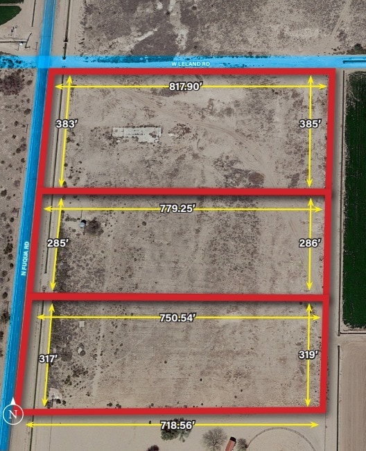
Surveys
503-09-004E
COMMENCING AT THE WEST QUARTER CORNER OF SECTION 18, TOWNSHIP 06S , RANGE 04 EAST, THENCE S-383.46 TO THE POINT OF BEGINNING THENCE E-779.25 THENCE S5D W-286.23 THENCE W-750.54 THENCE N-284.75 TO THE POINT OF BEGINNING, AKA PARCEL 2 IN BOOK 7 OF SURV
Residentialacreage
Pinal
X
Arizona
04021C1150E
5 AC
0
Pinal County
2025
Phoenix
941402
DEMOGRAPHICS near 2409 N Fuqua Rd
1 Mile
3 Mile
5 Mile
2024 Total Population
19
186
1,339
2029 Population
22
219
1,580
Pop Growth 2024-2029
+ 15.79%
+ 17.74%
+ 18.00%
Average Age
38
37
37
2024 Total Households
6
55
400
HH Growth 2024-2029
+ 16.67%
+ 18.18%
+ 17.50%
Median Household Inc
$49,999
$47,999
$48,269
Avg Household Size
3.80
3.40
3.40
2024 Avg HH Vehicles
3.00
2.00
2.00
Median Home Value
$199,999
$322,727
$315,584
Median Year Built
1994
1987
1987
Nearby Places
Map Layers
Map Styles
 Street
 Aerial
- Restaurants
- Banks
- Shops
- Fitness
- Groceries
SALE & LEASE HISTORY
LISTING DATE
SALE/LEASE

Sep 11, 2023
For Sale
Nearby Properties
Address
Land Use
TOTAL SIZE
Lot Size
Zoning
Address
Land Use
TOTAL SIZE
Lot Size
Zoning
34,415 SF
880 AC
Address
Land Use
TOTAL SIZE
Lot Size
Zoning
17.50 AC
Address
Land Use
TOTAL SIZE
Lot Size
Zoning
100,780 SF
107.47 AC
GR
Address
Land Use
TOTAL SIZE
Lot Size
Zoning
106,844 SF
10.02 AC
CI1
Address
Land Use
TOTAL SIZE
Lot Size
Zoning
61,448 SF
548.74 AC
GR
Address
Land Use
TOTAL SIZE
Lot Size
Zoning
7,013 SF
640 AC
CR3
Address
Land Use
TOTAL SIZE
Lot Size
Zoning
5,280 SF
1,015.45 AC
CI1
Address
Land Use
TOTAL SIZE
Lot Size
Zoning
8,320 SF
1.49 AC
Address
Land Use
TOTAL SIZE
Lot Size
Zoning
16,813 SF
160 AC
GR
Address
Land Use
TOTAL SIZE
Lot Size
Zoning
20,988 SF
9.19 AC
CI1
Address
Land Use
TOTAL SIZE
Lot Size
Zoning
9,290 SF
19.01 AC
CI2
Address
Land Use
TOTAL SIZE
Lot Size
Zoning
12,617 SF
179.38 AC
CI2
Address
Land Use
TOTAL SIZE
Lot Size
Zoning
5,407 SF
0.54 AC
CB2
Address
Land Use
TOTAL SIZE
Lot Size
Zoning
6,424 SF
2.50 AC
Address
Land Use
TOTAL SIZE
Lot Size
Zoning
249.49 AC
CI2
Address
Land Use
TOTAL SIZE
Lot Size
Zoning
1,749 SF
460 AC
Address
Land Use
TOTAL SIZE
Lot Size
Zoning
5,013 SF
0.72 AC
CB2
Address
Land Use
TOTAL SIZE
Lot Size
Zoning
5,640 SF
287.04 AC
GR
Address
Land Use
TOTAL SIZE
Lot Size
Zoning
4,446 SF
1.25 AC
Address
Land Use
TOTAL SIZE
Lot Size
Zoning
5,593 SF
63.70 AC
GR
Address
Land Use
TOTAL SIZE
Lot Size
Zoning
24,289 SF
53.20 AC
CI2
Address
Land Use
TOTAL SIZE
Lot Size
Zoning
8,750 SF
5 AC
CI2
Address
Land Use
TOTAL SIZE
Lot Size
Zoning
4,734 SF
280 AC
Address
Land Use
TOTAL SIZE
Lot Size
Zoning
5,880 SF
0.24 AC
Address
Land Use
TOTAL SIZE
Lot Size
Zoning
6,616 SF
0.67 AC
Address
Land Use
TOTAL SIZE
Lot Size
Zoning
2,177 SF
301.13 AC
CR3
Address
Land Use
TOTAL SIZE
Lot Size
Zoning
Address
Land Use
TOTAL SIZE
Lot Size
Zoning
3,863 SF
0.24 AC
Address
Land Use
TOTAL SIZE
Lot Size
Zoning
3,400 SF
0.34 AC
CB2
The World's #1 Commercial Real Estate Marketplace
Connect with us
© 2025 CoStar Group
The information above has been obtained from sources believed reliable. While we do not doubt its accuracy we have not verified it and make no guarantee, warranty or representation about it. It is your responsibility to independently confirm its accuracy and completeness. Any projections, opinions, assumptions, or estimates used are for example only and do not represent the current or future performance of the property. The value of this transaction to you depends on tax and other factors which should be evaluated by your tax, financial, and legal advisors. You and your advisors should conduct a careful, independent investigation of the property to determine to your satisfaction the suitability of the property for your needs.