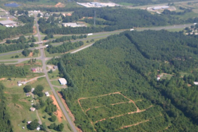
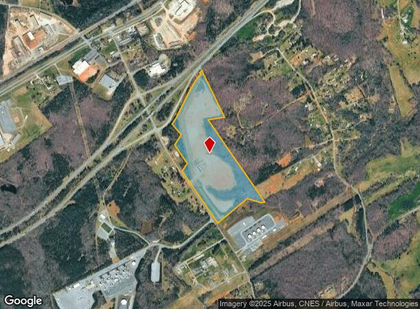
Property Record
241 Battleground Rd, Grover, NC 28073
NEARBY LISTINGS FOR SALE OR LEASE
Property Detail
241 Battleground Rd
Shelby, NC
Industrial Corr
10528
47.74 AC RD 216
Industrialacreage
Cleveland
X
North Carolina
45021C0100D
12
2025
47.74 AC
2025
Cleveland County
950603
Charlotte
DEMOGRAPHICS near 241 Battleground Rd
1 Mile
3 Mile
5 Mile
2024 Total Population
310
5,496
14,138
2029 Population
325
5,691
14,727
Pop Growth 2024-2029
+ 4.84%
+ 3.55%
+ 4.17%
Average Age
43
41
41
2024 Total Households
123
2,153
5,564
HH Growth 2024-2029
+ 5.69%
+ 3.58%
+ 4.19%
Median Household Inc
$54,166
$54,606
$56,587
Avg Household Size
2.40
2.50
2.50
2024 Avg HH Vehicles
3.00
2.00
2.00
Median Home Value
$138,372
$130,623
$139,781
Median Year Built
1984
1983
1983
Nearby Places
Map Layers
Map Styles
 Street
 Aerial
- Restaurants
- Banks
- Shops
- Fitness
- Groceries
PUBLIC TRANSPORTATION
AIRPORT
Charlotte/Douglas International
DRIVE
WALK
Distance
Charlotte/Douglas International
53 min
35.0 mi
Freight Ports
North Charleston Terminal
DRIVE
WALK
Distance
North Charleston Terminal
251 min
208.2 mi
SALE & LEASE HISTORY
LISTING DATE
SALE/LEASE

Sep 24, 2016
For Sale
Nearby Properties
Address
Land Use
TOTAL SIZE
Lot Size
Zoning
Address
Land Use
TOTAL SIZE
Lot Size
Zoning
148,809 SF
99.49 AC
LI
Address
Land Use
TOTAL SIZE
Lot Size
Zoning
295,045 SF
45.35 AC
LI
Address
Land Use
TOTAL SIZE
Lot Size
Zoning
3,000 SF
19.94 AC
HI
Address
Land Use
TOTAL SIZE
Lot Size
Zoning
18,952 SF
6 AC
AA1
Address
Land Use
TOTAL SIZE
Lot Size
Zoning
51,480 SF
7.94 AC
LI
Address
Land Use
TOTAL SIZE
Lot Size
Zoning
2,210 SF
2.96 AC
R15
Address
Land Use
TOTAL SIZE
Lot Size
Zoning
9,500 SF
16.88 AC
R20
Address
Land Use
TOTAL SIZE
Lot Size
Zoning
25,000 SF
9.65 AC
LI
Address
Land Use
TOTAL SIZE
Lot Size
Zoning
2,700 SF
11.39 AC
HI
Address
Land Use
TOTAL SIZE
Lot Size
Zoning
21,248 SF
24.69 AC
LI
Address
Land Use
TOTAL SIZE
Lot Size
Zoning
40,000 SF
11.11 AC
AA3
Address
Land Use
TOTAL SIZE
Lot Size
Zoning
3,980 SF
208.89 AC
HI
Address
Land Use
TOTAL SIZE
Lot Size
Zoning
7,200 SF
10.85 AC
HI
Address
Land Use
TOTAL SIZE
Lot Size
Zoning
9,944 SF
4.64 AC
R10
Address
Land Use
TOTAL SIZE
Lot Size
Zoning
5,143 SF
199.95 AC
LI
Address
Land Use
TOTAL SIZE
Lot Size
Zoning
6,000 SF
3.85 AC
AA1
Address
Land Use
TOTAL SIZE
Lot Size
Zoning
12,754 SF
4.70 AC
R10
Address
Land Use
TOTAL SIZE
Lot Size
Zoning
18,542 SF
9.80 AC
LI
Address
Land Use
TOTAL SIZE
Lot Size
Zoning
38,960 SF
199 AC
LI
Address
Land Use
TOTAL SIZE
Lot Size
Zoning
34,300 SF
12.34 AC
LI
Address
Land Use
TOTAL SIZE
Lot Size
Zoning
12,257 SF
1.96 AC
AA1
Address
Land Use
TOTAL SIZE
Lot Size
Zoning
4,506 SF
6.76 AC
R15
Address
Land Use
TOTAL SIZE
Lot Size
Zoning
3,750 SF
34.60 AC
R10
Address
Land Use
TOTAL SIZE
Lot Size
Zoning
52,000 SF
15.57 AC
LI
Address
Land Use
TOTAL SIZE
Lot Size
Zoning
10,500 SF
2.72 AC
GB
Address
Land Use
TOTAL SIZE
Lot Size
Zoning
63.43 AC
Address
Land Use
TOTAL SIZE
Lot Size
Zoning
2,800 SF
4 AC
R15
Address
Land Use
TOTAL SIZE
Lot Size
Zoning
24,425 SF
28.40 AC
HI
Address
Land Use
TOTAL SIZE
Lot Size
Zoning
44.34 AC
AA1
Address
Land Use
TOTAL SIZE
Lot Size
Zoning
47.11 AC
R10
The World's #1 Commercial Real Estate Marketplace
Connect with us
© 2025 CoStar Group
The information above has been obtained from sources believed reliable. While we do not doubt its accuracy we have not verified it and make no guarantee, warranty or representation about it. It is your responsibility to independently confirm its accuracy and completeness. Any projections, opinions, assumptions, or estimates used are for example only and do not represent the current or future performance of the property. The value of this transaction to you depends on tax and other factors which should be evaluated by your tax, financial, and legal advisors. You and your advisors should conduct a careful, independent investigation of the property to determine to your satisfaction the suitability of the property for your needs.