Property Record
241 E Oglethorpe Blvd, Albany, GA 31705
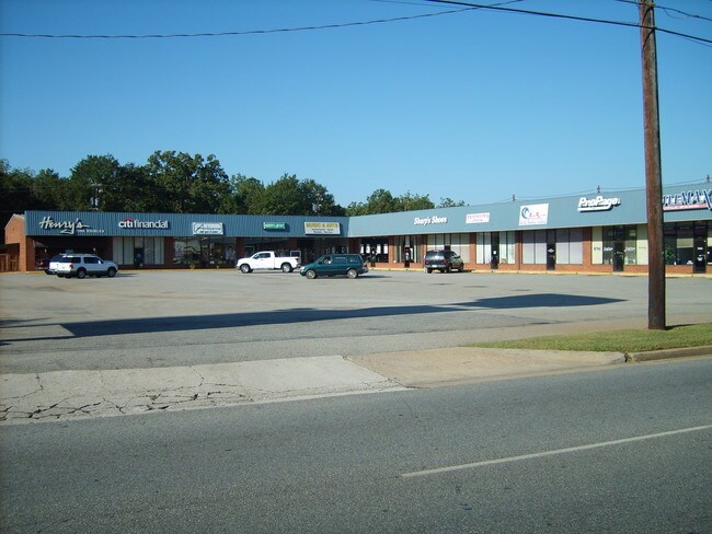

Property Detail
241 E Oglethorpe Blvd
0000C-00033-001
SHACKELFORD ADD
Stripcommercialcenter
Dougherty
C-3
Georgia
B and X Area of moderate flood hazard, usually the area between the limits of the 100-year and 500-year floods.
3.50 AC
2025
Albany/Southwest
2025
Other Market Areas
000200
Albany, GA
10,270 SF
NEARBY LISTINGS FOR SALE OR LEASE
DEMOGRAPHICS near 241 E Oglethorpe Blvd
1 mile
3 mile
5 mile
2025 Total Population
3,646
35,467
67,916
2030 Population
3,643
35,100
67,000
Pop Growth 2025-2030
(0.08%)
(1.03%)
(1.35%)
Average Age
33
37
38
2025 Total Households
1,336
14,305
27,900
HH Growth 2025-2030
+ 0.15%
(1.01%)
(1.44%)
Median Household Inc
$18,256
$31,318
$43,451
Avg Household Size
2.20
2.30
2.30
2025 Avg HH Vehicles
1.00
1.00
1.00
Median Home Value
$63,361
$81,210
$136,554
Median Year Built
1971
1966
1973
Nearby Places
Map Layers
Map Styles
 Street
 Aerial
Layers
 Traffic
 Biking
Places
Listings with unknown addresses are not visible on the map
- Restaurants
- Banks
- Shops
- Fitness
- Groceries
PUBLIC TRANSPORTATION
AIRPORT
Southwest Georgia Regional
Drive
Walk
Distance
Southwest Georgia Regional
12 min
5.2 mi
SALE & LEASE HISTORY
LISTING DATE
SALE/LEASE

Sep 25, 2016
For Lease
Sep 23, 2016
For Sale
Feb 22, 2017
For Lease
Feb 22, 2017
For Sale
Nearby Properties
Address
Land Use
TOTAL SIZE
Lot Size
Zoning
Address
Land Use
TOTAL SIZE
Lot Size
Zoning
Address
Land Use
TOTAL SIZE
Lot Size
Zoning
34,888 SF
164.47 AC
M-2
Address
Land Use
TOTAL SIZE
Lot Size
Zoning
58.86 AC
C-3
Address
Land Use
TOTAL SIZE
Lot Size
Zoning
51,008 SF
19.48 AC
C-5
Address
Land Use
TOTAL SIZE
Lot Size
Zoning
274,484 SF
16.31 AC
C-5
Address
Land Use
TOTAL SIZE
Lot Size
Zoning
1.77 AC
C-2
Address
Land Use
TOTAL SIZE
Lot Size
Zoning
15.20 AC
C-2
Address
Land Use
TOTAL SIZE
Lot Size
Zoning
2.53 AC
C-2
Address
Land Use
TOTAL SIZE
Lot Size
Zoning
1.75 AC
C-2
Address
Land Use
TOTAL SIZE
Lot Size
Zoning
0.83 AC
C-2
Address
Land Use
TOTAL SIZE
Lot Size
Zoning
141,600 SF
45.43 AC
C-1
Address
Land Use
TOTAL SIZE
Lot Size
Zoning
77,688 SF
2.93 AC
C-3
Address
Land Use
TOTAL SIZE
Lot Size
Zoning
70,596 SF
2.38 AC
C-2
Address
Land Use
TOTAL SIZE
Lot Size
Zoning
232,840 SF
49.88 AC
M-1
Address
Land Use
TOTAL SIZE
Lot Size
Zoning
9,000 SF
184.88 AC
M-2
Address
Land Use
TOTAL SIZE
Lot Size
Zoning
382,331 SF
30.50 AC
M-1
Address
Land Use
TOTAL SIZE
Lot Size
Zoning
87,288 SF
1.22 AC
C-5
Address
Land Use
TOTAL SIZE
Lot Size
Zoning
0.54 AC
C-2
Address
Land Use
TOTAL SIZE
Lot Size
Zoning
9.37 AC
C-3
Address
Land Use
TOTAL SIZE
Lot Size
Zoning
8 AC
M-1
Address
Land Use
TOTAL SIZE
Lot Size
Zoning
475,976 SF
51.30 AC
M-1
Address
Land Use
TOTAL SIZE
Lot Size
Zoning
23,040 SF
10.59 AC
C-R
Address
Land Use
TOTAL SIZE
Lot Size
Zoning
0.52 AC
C-2
Address
Land Use
TOTAL SIZE
Lot Size
Zoning
98,560 SF
19.64 AC
C-R
Address
Land Use
TOTAL SIZE
Lot Size
Zoning
82,944 SF
8.10 AC
C-R
Address
Land Use
TOTAL SIZE
Lot Size
Zoning
25,777 SF
9.30 AC
C-3
Address
Land Use
TOTAL SIZE
Lot Size
Zoning
13,958 SF
15 AC
M-1
Address
Land Use
TOTAL SIZE
Lot Size
Zoning
28,713 SF
9.96 AC
C-3
Address
Land Use
TOTAL SIZE
Lot Size
Zoning
30,336 SF
19.19 AC
C-R
Address
Land Use
TOTAL SIZE
Lot Size
Zoning
146,281 SF
17.87 AC
M-1
The World's #1 Commercial Real Estate Marketplace
Connect with us
© 2026 CoStar Group
The information above has been obtained from sources believed reliable. While we do not doubt its accuracy we have not verified it and make no guarantee, warranty or representation about it. It is your responsibility to independently confirm its accuracy and completeness. Any projections, opinions, assumptions, or estimates used are for example only and do not represent the current or future performance of the property. The value of this transaction to you depends on tax and other factors which should be evaluated by your tax, financial, and legal advisors. You and your advisors should conduct a careful, independent investigation of the property to determine to your satisfaction the suitability of the property for your needs.