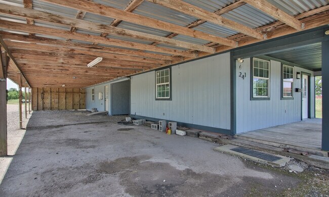
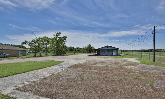
Property Record
241 Mckeever Rd, Rosharon, TX 77583

Property Detail
241 Mckeever Rd
0170-00-000-4500-907
0170 M ESCALERO, ACRES 1.66
Commercialnec
Fort Bend
S
Texas
B and X Area of moderate flood hazard, usually the area between the limits of the 100-year and 500-year floods.
1.66 AC
2024
E Fort Bend Co/Sugar Land
2025
Houston
674506
Houston-Pasadena-The Woodlands, TX
400 SF
NEARBY LISTINGS FOR SALE OR LEASE
DEMOGRAPHICS near 241 Mckeever Rd
1 mile
3 mile
5 mile
2025 Total Population
6,182
59,625
144,338
2030 Population
7,127
68,036
164,225
Pop Growth 2025-2030
+ 15.29%
+ 14.11%
+ 13.78%
Average Age
35
35
36
2025 Total Households
1,854
18,042
44,600
HH Growth 2025-2030
+ 15.64%
+ 14.44%
+ 14.12%
Median Household Inc
$73,743
$99,067
$119,220
Avg Household Size
3.30
3.30
3.20
2025 Avg HH Vehicles
2.00
2.00
2.00
Median Home Value
$247,965
$308,801
$367,005
Median Year Built
2006
2009
2010
Nearby Places
Map Layers
Map Styles
 Street
 Aerial
Transit
 Traffic
 Biking
Places
Listings with unknown addresses are not visible on the map
- Restaurants
- Banks
- Shops
- Fitness
- Groceries
PUBLIC TRANSPORTATION
AIRPORT
William P Hobby
Drive
Walk
Distance
William P Hobby
34 min
19.2 mi
Freight Ports
Port of Houston
Drive
Walk
Distance
Port of Houston
39 min
23.8 mi
SALE & LEASE HISTORY
LISTING DATE
SALE/LEASE

May 02, 2024
For Sale
Jun 26, 2025
For Lease
Nearby Properties
Address
Land Use
TOTAL SIZE
Lot Size
Zoning
Address
Land Use
TOTAL SIZE
Lot Size
Zoning
Address
Land Use
TOTAL SIZE
Lot Size
Zoning
344,620 SF
78.14 AC
SY
Address
Land Use
TOTAL SIZE
Lot Size
Zoning
0.08 AC
Address
Land Use
TOTAL SIZE
Lot Size
Zoning
1,764 SF
39.64 AC
ST
Address
Land Use
TOTAL SIZE
Lot Size
Zoning
82,400 SF
10.85 AC
I
Address
Land Use
TOTAL SIZE
Lot Size
Zoning
96,295 SF
12.04 AC
I
Address
Land Use
TOTAL SIZE
Lot Size
Zoning
537.89 AC
Address
Land Use
TOTAL SIZE
Lot Size
Zoning
127,500 SF
7.60 AC
Address
Land Use
TOTAL SIZE
Lot Size
Zoning
105,790 SF
12.82 AC
X
Address
Land Use
TOTAL SIZE
Lot Size
Zoning
13.85 AC
Address
Land Use
TOTAL SIZE
Lot Size
Zoning
70,000 SF
64.91 AC
Address
Land Use
TOTAL SIZE
Lot Size
Zoning
132,938 SF
29 AC
MZY
Address
Land Use
TOTAL SIZE
Lot Size
Zoning
2,000 SF
24.85 AC
Address
Land Use
TOTAL SIZE
Lot Size
Zoning
28,633 SF
9.36 AC
Address
Land Use
TOTAL SIZE
Lot Size
Zoning
224.26 AC
Address
Land Use
TOTAL SIZE
Lot Size
Zoning
4.30 AC
Address
Land Use
TOTAL SIZE
Lot Size
Zoning
17,481 SF
12.54 AC
Address
Land Use
TOTAL SIZE
Lot Size
Zoning
37,000 SF
6.06 AC
0218
Address
Land Use
TOTAL SIZE
Lot Size
Zoning
Address
Land Use
TOTAL SIZE
Lot Size
Zoning
114,723 SF
20.13 AC
0007
Address
Land Use
TOTAL SIZE
Lot Size
Zoning
2.92 AC
Address
Land Use
TOTAL SIZE
Lot Size
Zoning
11,400 SF
2.10 AC
Address
Land Use
TOTAL SIZE
Lot Size
Zoning
68,340 SF
3.74 AC
XS
Address
Land Use
TOTAL SIZE
Lot Size
Zoning
2.31 AC
S
Address
Land Use
TOTAL SIZE
Lot Size
Zoning
7.86 AC
SN
Address
Land Use
TOTAL SIZE
Lot Size
Zoning
13,134 SF
2.08 AC
Address
Land Use
TOTAL SIZE
Lot Size
Zoning
70,260 SF
4.41 AC
SY
Address
Land Use
TOTAL SIZE
Lot Size
Zoning
16,512 SF
3.04 AC
Address
Land Use
TOTAL SIZE
Lot Size
Zoning
20,770 SF
2.93 AC
XY
Address
Land Use
TOTAL SIZE
Lot Size
Zoning
14,543 SF
2.22 AC
The World's #1 Commercial Real Estate Marketplace
Connect with us
© 2026 CoStar Group
The information above has been obtained from sources believed reliable. While we do not doubt its accuracy we have not verified it and make no guarantee, warranty or representation about it. It is your responsibility to independently confirm its accuracy and completeness. Any projections, opinions, assumptions, or estimates used are for example only and do not represent the current or future performance of the property. The value of this transaction to you depends on tax and other factors which should be evaluated by your tax, financial, and legal advisors. You and your advisors should conduct a careful, independent investigation of the property to determine to your satisfaction the suitability of the property for your needs.