Property Record
241 Nestlerode St, Lock Haven, PA 17745

Property Detail
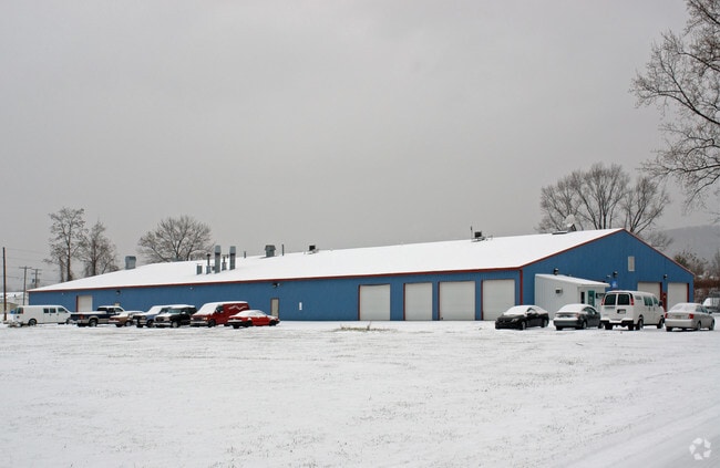
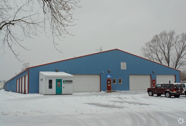
241 Nestlerode St
006-20654
AUTO PARTS WAREHOUSE LERTA
Warehouse
CLINTON
C
Pennsylvania
AE The base floodplain where base flood elevations are provided. AE Zones are now used on new format FIRMs instead of A1-A30 Zones.
5.59 AC
2026
Pennsylvania Central Area
2026
Other Market Areas
030300
Lock Haven, PA
76,160 SF
NEARBY LISTINGS FOR SALE OR LEASE
-
-
View all Lock Haven listings for sale on LoopNet.com
DEMOGRAPHICS near 241 Nestlerode St
1 mile
3 mile
5 mile
2025 Total Population
5,946
15,163
21,123
2030 Population
5,854
15,116
20,938
Pop Growth 2025-2030
(1.55%)
(0.31%)
(0.88%)
Average Age
36
40
41
2025 Total Households
2,410
6,076
8,415
HH Growth 2025-2030
(1.54%)
(0.39%)
(0.96%)
Median Household Inc
$42,536
$47,841
$54,020
Avg Household Size
2.10
2.20
2.30
2025 Avg HH Vehicles
2.00
2.00
2.00
Median Home Value
$140,113
$168,190
$181,834
Median Year Built
1964
1965
1967
Nearby Places
Map Layers
Map Styles
 Street
 Aerial
Layers
 Traffic
 Biking
Places
Listings with unknown addresses are not visible on the map
- Restaurants
- Banks
- Shops
- Fitness
- Groceries
PUBLIC TRANSPORTATION
AIRPORT
State College Regional
Drive
Walk
Distance
State College Regional
55 min
34.0 mi
Freight Ports
Port of Baltimore
Drive
Walk
Distance
Port of Baltimore
255 min
191.1 mi
Nearby Properties
Address
Land Use
TOTAL SIZE
Lot Size
Zoning
Address
Land Use
TOTAL SIZE
Lot Size
Zoning
277.71 AC
Address
Land Use
TOTAL SIZE
Lot Size
Zoning
12,048 SF
4.75 AC
PI
Address
Land Use
TOTAL SIZE
Lot Size
Zoning
80,760 SF
4.37 AC
PI
Address
Land Use
TOTAL SIZE
Lot Size
Zoning
10.48 AC
Address
Land Use
TOTAL SIZE
Lot Size
Zoning
364,870 SF
20.87 AC
HI
Address
Land Use
TOTAL SIZE
Lot Size
Zoning
85,160 SF
1.48 AC
PI
Address
Land Use
TOTAL SIZE
Lot Size
Zoning
64,140 SF
3.45 AC
Address
Land Use
TOTAL SIZE
Lot Size
Zoning
10,659 SF
12.85 AC
RM
Address
Land Use
TOTAL SIZE
Lot Size
Zoning
339,124 SF
17.01 AC
Address
Land Use
TOTAL SIZE
Lot Size
Zoning
75,172 SF
0.28 AC
PI
Address
Land Use
TOTAL SIZE
Lot Size
Zoning
45,914 SF
13.21 AC
IND
Address
Land Use
TOTAL SIZE
Lot Size
Zoning
94,336 SF
1.87 AC
PI
Address
Land Use
TOTAL SIZE
Lot Size
Zoning
106,857 SF
6.56 AC
PI
Address
Land Use
TOTAL SIZE
Lot Size
Zoning
52,120 SF
1.98 AC
PI
Address
Land Use
TOTAL SIZE
Lot Size
Zoning
2,440 SF
8.02 AC
RM
Address
Land Use
TOTAL SIZE
Lot Size
Zoning
108,536 SF
1.59 AC
Address
Land Use
TOTAL SIZE
Lot Size
Zoning
33,240 SF
4.49 AC
Address
Land Use
TOTAL SIZE
Lot Size
Zoning
1,896 SF
2.19 AC
Address
Land Use
TOTAL SIZE
Lot Size
Zoning
242,674 SF
12.67 AC
HI
Address
Land Use
TOTAL SIZE
Lot Size
Zoning
54,138 SF
2.92 AC
Address
Land Use
TOTAL SIZE
Lot Size
Zoning
68,560 SF
1.47 AC
Address
Land Use
TOTAL SIZE
Lot Size
Zoning
76,398 SF
4.10 AC
RH
Address
Land Use
TOTAL SIZE
Lot Size
Zoning
27,540 SF
102.11 AC
AI
Address
Land Use
TOTAL SIZE
Lot Size
Zoning
57,893 SF
0.75 AC
Address
Land Use
TOTAL SIZE
Lot Size
Zoning
26,784 SF
1.97 AC
GC
Address
Land Use
TOTAL SIZE
Lot Size
Zoning
31,063 SF
1.20 AC
GC
Address
Land Use
TOTAL SIZE
Lot Size
Zoning
963,220 SF
16.93 AC
Address
Land Use
TOTAL SIZE
Lot Size
Zoning
60,026 SF
5.29 AC
GC
Address
Land Use
TOTAL SIZE
Lot Size
Zoning
20,348 SF
5.22 AC
I
Address
Land Use
TOTAL SIZE
Lot Size
Zoning
11,050 SF
15.25 AC
IND
The World's #1 Commercial Real Estate Marketplace
Connect with us
© 2026 CoStar Group
The information above has been obtained from sources believed reliable. While we do not doubt its accuracy we have not verified it and make no guarantee, warranty or representation about it. It is your responsibility to independently confirm its accuracy and completeness. Any projections, opinions, assumptions, or estimates used are for example only and do not represent the current or future performance of the property. The value of this transaction to you depends on tax and other factors which should be evaluated by your tax, financial, and legal advisors. You and your advisors should conduct a careful, independent investigation of the property to determine to your satisfaction the suitability of the property for your needs.