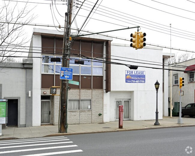
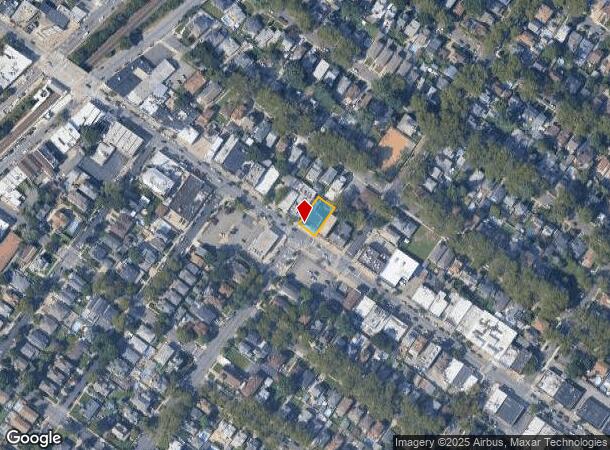
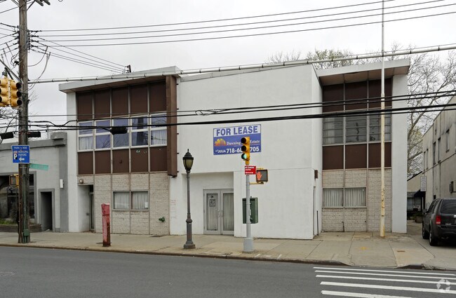
Property Record
241 New Dorp Ln, Staten Island, NY 10306
NEARBY LISTINGS FOR SALE OR LEASE
Property Detail
241 New Dorp Ln
03637-0006
Staten Island
Privateschool
New York
X
6
3604970328F
0.14 AC
2024
Staten Island
2025
Long Island (New York)
012200
New York-Jersey City-White Plains, NY-NJ
7,184 SF
DEMOGRAPHICS near 241 New Dorp Ln
1 Mile
3 Mile
5 Mile
2024 Total Population
35,683
185,003
424,881
2029 Population
35,274
182,686
418,779
Pop Growth 2024-2029
(1.15%)
(1.25%)
(1.44%)
Average Age
43
42
41
2024 Total Households
12,796
65,481
147,803
HH Growth 2024-2029
(1.24%)
(1.30%)
(1.46%)
Median Household Inc
$87,751
$91,410
$87,848
Avg Household Size
2.70
2.80
2.80
2024 Avg HH Vehicles
2.00
2.00
2.00
Median Home Value
$674,434
$674,913
$648,503
Median Year Built
1964
1973
1971
Nearby Places
- Restaurants
- Banks
- Shops
- Fitness
- Groceries
PUBLIC TRANSPORTATION
TRANSIT/SUBWAY
New Dorp (Staten Island Railway - New York MTA Subway (The Subway))
DRIVE
WALK
Distance
New Dorp (Staten Island Railway - New York MTA Subway (The Subway))
1 min
4 min
0.2 mi
Grant City (Staten Island Railway - New York MTA Subway (The Subway))
DRIVE
WALK
Distance
Grant City (Staten Island Railway - New York MTA Subway (The Subway))
2 min
13 min
0.7 mi
Oakwood Heights (Staten Island Railway - New York MTA Subway (The Subway))
DRIVE
WALK
Distance
Oakwood Heights (Staten Island Railway - New York MTA Subway (The Subway))
3 min
20 min
1.0 mi
COMMUTER RAIL
New Dorp (Staten Island Railway - New York MTA Subway (The Subway))
DRIVE
WALK
Distance
New Dorp (Staten Island Railway - New York MTA Subway (The Subway))
1 min
4 min
0.2 mi
Grant City (Staten Island Railway - New York MTA Subway (The Subway))
DRIVE
WALK
Distance
Grant City (Staten Island Railway - New York MTA Subway (The Subway))
3 min
13 min
0.7 mi
AIRPORT
Newark Liberty International
DRIVE
WALK
Distance
Newark Liberty International
29 min
16.4 mi
LaGuardia
DRIVE
WALK
Distance
LaGuardia
43 min
23.3 mi
John F Kennedy International
DRIVE
WALK
Distance
John F Kennedy International
46 min
25.8 mi
Freight Ports
New York Container Terminal
DRIVE
WALK
Distance
New York Container Terminal
16 min
7.2 mi
SALE & LEASE HISTORY
LISTING DATE
SALE/LEASE

Sep 25, 2016
For Lease
Nearby Properties
Address
Land Use
TOTAL SIZE
Lot Size
Zoning
Address
Land Use
TOTAL SIZE
Lot Size
Zoning
3,600 SF
731.18 AC
PARK
Address
Land Use
TOTAL SIZE
Lot Size
Zoning
633,280 SF
202.90 AC
R3-2
Address
Land Use
TOTAL SIZE
Lot Size
Zoning
686,130 SF
189.62 AC
R3-2
Address
Land Use
TOTAL SIZE
Lot Size
Zoning
1,258,042 SF
14.47 AC
C4-1
Address
Land Use
TOTAL SIZE
Lot Size
Zoning
640,077 SF
19.34 AC
R3-1
Address
Land Use
TOTAL SIZE
Lot Size
Zoning
566,000 SF
103.31 AC
R3-2
Address
Land Use
TOTAL SIZE
Lot Size
Zoning
135,000 SF
117.71 AC
PARK
Address
Land Use
TOTAL SIZE
Lot Size
Zoning
310,560 SF
15.90 AC
C4-1
Address
Land Use
TOTAL SIZE
Lot Size
Zoning
494,840 SF
34.77 AC
R3-2
Address
Land Use
TOTAL SIZE
Lot Size
Zoning
195,395 SF
12.04 AC
R3-2
Address
Land Use
TOTAL SIZE
Lot Size
Zoning
418,012 SF
6.74 AC
R3-1
Address
Land Use
TOTAL SIZE
Lot Size
Zoning
421,275 SF
18.95 AC
R3-2
Address
Land Use
TOTAL SIZE
Lot Size
Zoning
111,000 SF
186.03 AC
PARK
Address
Land Use
TOTAL SIZE
Lot Size
Zoning
294,320 SF
15 AC
R3-2
Address
Land Use
TOTAL SIZE
Lot Size
Zoning
505,000 SF
3.79 AC
R3A
Address
Land Use
TOTAL SIZE
Lot Size
Zoning
240 SF
47.41 AC
R3-2
Address
Land Use
TOTAL SIZE
Lot Size
Zoning
476,145 SF
50.97 AC
R3-1
Address
Land Use
TOTAL SIZE
Lot Size
Zoning
48,500 SF
61.98 AC
R3-2
Address
Land Use
TOTAL SIZE
Lot Size
Zoning
377,678 SF
25.40 AC
C4-1
Address
Land Use
TOTAL SIZE
Lot Size
Zoning
77,502 SF
1.29 AC
R3-1
Address
Land Use
TOTAL SIZE
Lot Size
Zoning
900 SF
50 AC
R1-1
Address
Land Use
TOTAL SIZE
Lot Size
Zoning
319,000 SF
18.76 AC
C4-1
Address
Land Use
TOTAL SIZE
Lot Size
Zoning
151,637 SF
7.41 AC
C4-1
Address
Land Use
TOTAL SIZE
Lot Size
Zoning
45,570 SF
206.38 AC
PARKUS
Address
Land Use
TOTAL SIZE
Lot Size
Zoning
26.45 AC
PARK
Address
Land Use
TOTAL SIZE
Lot Size
Zoning
7,410 SF
44.60 AC
R1-1
Address
Land Use
TOTAL SIZE
Lot Size
Zoning
151,080 SF
17.59 AC
R1-2
Address
Land Use
TOTAL SIZE
Lot Size
Zoning
37.30 AC
PARK
Address
Land Use
TOTAL SIZE
Lot Size
Zoning
180,000 SF
2.28 AC
R2
Address
Land Use
TOTAL SIZE
Lot Size
Zoning
126,000 SF
6.36 AC
R3-2
The World's #1 Commercial Real Estate Marketplace
Connect with us
© 2025 CoStar Group
The information above has been obtained from sources believed reliable. While we do not doubt its accuracy we have not verified it and make no guarantee, warranty or representation about it. It is your responsibility to independently confirm its accuracy and completeness. Any projections, opinions, assumptions, or estimates used are for example only and do not represent the current or future performance of the property. The value of this transaction to you depends on tax and other factors which should be evaluated by your tax, financial, and legal advisors. You and your advisors should conduct a careful, independent investigation of the property to determine to your satisfaction the suitability of the property for your needs.