Property Record
237 S Westfield St, Feeding Hills, MA 01030
Current Lease Availabilities
NEARBY LISTINGS FOR SALE OR LEASE
Property Detail
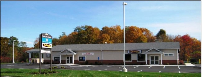
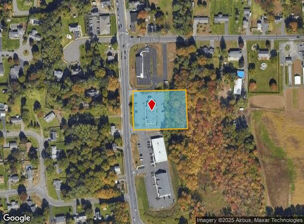
237 S Westfield St
AGAW-000008E-000002-000001
Hampden
Financialbuilding
Massachusetts
X
1
25013C0391E
1.63 AC
2025
Hampden County
2025
Hartford
813205
Springfield, MA
5,500 SF
DEMOGRAPHICS near 237 S Westfield St
1 Mile
3 Mile
5 Mile
2024 Total Population
3,134
22,204
72,939
2029 Population
3,150
21,785
71,610
Pop Growth 2024-2029
+ 0.51%
(1.89%)
(1.82%)
Average Age
44
44
42
2024 Total Households
1,236
8,918
29,142
HH Growth 2024-2029
+ 0.40%
(2.02%)
(1.94%)
Median Household Inc
$85,123
$89,182
$81,395
Avg Household Size
2.50
2.40
2.40
2024 Avg HH Vehicles
2.00
2.00
2.00
Median Home Value
$291,885
$282,333
$286,911
Median Year Built
1975
1969
1964
Nearby Places
- Restaurants
- Banks
- Shops
- Fitness
- Groceries
PUBLIC TRANSPORTATION
COMMUTER RAIL
Springfield (Amtrak Hartford Line - Amtrak, Hartford Line - Amtrak, Lake Shore Limited - Amtrak, Northeast Regional - Amtrak, Valley Flyer - Amtrak, Vermonter - Amtrak)
DRIVE
WALK
Distance
Springfield (Amtrak Hartford Line - Amtrak, Hartford Line - Amtrak, Lake Shore Limited - Amtrak, Northeast Regional - Amtrak, Valley Flyer - Amtrak, Vermonter - Amtrak)
10 min
6.5 mi
AIRPORT
Bradley International
DRIVE
WALK
Distance
Bradley International
26 min
10.9 mi
Freight Ports
Port of New Haven
DRIVE
WALK
Distance
Port of New Haven
87 min
62.6 mi
Nearby Properties
Address
Land Use
TOTAL SIZE
Lot Size
Zoning
Address
Land Use
TOTAL SIZE
Lot Size
Zoning
36.53 AC
IB
Address
Land Use
TOTAL SIZE
Lot Size
Zoning
236,032 SF
41.65 AC
RA2
Address
Land Use
TOTAL SIZE
Lot Size
Zoning
133,822 SF
40.51 AC
RA2
Address
Land Use
TOTAL SIZE
Lot Size
Zoning
2,022 SF
33.70 AC
AG
Address
Land Use
TOTAL SIZE
Lot Size
Zoning
18.51 AC
BA
Address
Land Use
TOTAL SIZE
Lot Size
Zoning
811.20 AC
RA2
Address
Land Use
TOTAL SIZE
Lot Size
Zoning
241,663 SF
13.59 AC
IA
Address
Land Use
TOTAL SIZE
Lot Size
Zoning
205,380 SF
15.41 AC
IA
Address
Land Use
TOTAL SIZE
Lot Size
Zoning
186,125 SF
14.69 AC
IA
Address
Land Use
TOTAL SIZE
Lot Size
Zoning
6.73 AC
BA
Address
Land Use
TOTAL SIZE
Lot Size
Zoning
125,000 SF
15.35 AC
IA
Address
Land Use
TOTAL SIZE
Lot Size
Zoning
67,046 SF
11.63 AC
BA
Address
Land Use
TOTAL SIZE
Lot Size
Zoning
12.26 AC
IB
Address
Land Use
TOTAL SIZE
Lot Size
Zoning
68,644 SF
5.20 AC
RA2
Address
Land Use
TOTAL SIZE
Lot Size
Zoning
43,582 SF
4.39 AC
BA
Address
Land Use
TOTAL SIZE
Lot Size
Zoning
38.59 AC
RA2
Address
Land Use
TOTAL SIZE
Lot Size
Zoning
62,471 SF
28.11 AC
RA2
Address
Land Use
TOTAL SIZE
Lot Size
Zoning
2.70 AC
RB
Address
Land Use
TOTAL SIZE
Lot Size
Zoning
146,211 SF
11.72 AC
IA
Address
Land Use
TOTAL SIZE
Lot Size
Zoning
8.85 AC
RA2
Address
Land Use
TOTAL SIZE
Lot Size
Zoning
69,430 SF
10.30 AC
IB
Address
Land Use
TOTAL SIZE
Lot Size
Zoning
4,615 SF
4.59 AC
BA
Address
Land Use
TOTAL SIZE
Lot Size
Zoning
93,875 SF
13.49 AC
IA
Address
Land Use
TOTAL SIZE
Lot Size
Zoning
51,898 SF
6.88 AC
IB
Address
Land Use
TOTAL SIZE
Lot Size
Zoning
1.69 AC
BA
Address
Land Use
TOTAL SIZE
Lot Size
Zoning
66,443 SF
39.75 AC
BA
Address
Land Use
TOTAL SIZE
Lot Size
Zoning
29,500 SF
6.09 AC
Address
Land Use
TOTAL SIZE
Lot Size
Zoning
78,176 SF
6.27 AC
IG
Address
Land Use
TOTAL SIZE
Lot Size
Zoning
8.94 AC
RA4
Address
Land Use
TOTAL SIZE
Lot Size
Zoning
4.67 AC
BA
The World's #1 Commercial Real Estate Marketplace
Connect with us
© 2025 CoStar Group
The information above has been obtained from sources believed reliable. While we do not doubt its accuracy we have not verified it and make no guarantee, warranty or representation about it. It is your responsibility to independently confirm its accuracy and completeness. Any projections, opinions, assumptions, or estimates used are for example only and do not represent the current or future performance of the property. The value of this transaction to you depends on tax and other factors which should be evaluated by your tax, financial, and legal advisors. You and your advisors should conduct a careful, independent investigation of the property to determine to your satisfaction the suitability of the property for your needs.