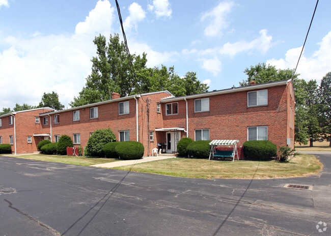
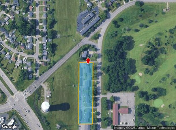
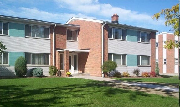
Property Record
2410 Colvin Boulevard Ext, Tonawanda, NY 14150
NEARBY LISTINGS FOR SALE OR LEASE
Property Detail
2410 Colvin Boulevard Ext
Buffalo-Cheektowaga-Niagara Falls, NY
Holland Land Companys Survey
146489-053-070-0014-016-100
1114.5 N EGGERT RD 1313 PT 4 + 5-19 607.5 X 141.23
Apartment
Erie
X
New York
36029C0063J
16.100
2025
1.97 AC
2024
Tonawanda
007905
Buffalo/Niagara Falls
8,164 SF
DEMOGRAPHICS near 2410 Colvin Boulevard Ext
1 Mile
3 Mile
5 Mile
2024 Total Population
11,233
118,264
266,811
2029 Population
11,211
117,382
263,005
Pop Growth 2024-2029
(0.20%)
(0.75%)
(1.43%)
Average Age
44
41
40
2024 Total Households
5,371
51,087
113,710
HH Growth 2024-2029
(0.32%)
(0.84%)
(1.48%)
Median Household Inc
$66,567
$62,776
$62,554
Avg Household Size
2.00
2.10
2.20
2024 Avg HH Vehicles
2.00
2.00
2.00
Median Home Value
$166,870
$165,212
$179,818
Median Year Built
1957
1954
1953
Nearby Places
- Restaurants
- Banks
- Shops
- Fitness
- Groceries
PUBLIC TRANSPORTATION
AIRPORT
Buffalo Niagara International
DRIVE
WALK
Distance
Buffalo Niagara International
17 min
10.0 mi
Niagara Falls International
DRIVE
WALK
Distance
Niagara Falls International
19 min
10.2 mi
Freight Ports
Port of Toledo
DRIVE
WALK
Distance
Port of Toledo
372 min
314.6 mi
Nearby Properties
Address
Land Use
TOTAL SIZE
Lot Size
Zoning
Address
Land Use
TOTAL SIZE
Lot Size
Zoning
139,224 SF
13.72 AC
WID
Address
Land Use
TOTAL SIZE
Lot Size
Zoning
109,328 SF
12.77 AC
GB
Address
Land Use
TOTAL SIZE
Lot Size
Zoning
409,925 SF
36.41 AC
CTR-5
Address
Land Use
TOTAL SIZE
Lot Size
Zoning
16,065 SF
19.75 AC
Address
Land Use
TOTAL SIZE
Lot Size
Zoning
8,565 SF
22.65 AC
Address
Land Use
TOTAL SIZE
Lot Size
Zoning
239,735 SF
17.73 AC
TND
Address
Land Use
TOTAL SIZE
Lot Size
Zoning
12,262 SF
29 AC
MFR-5
Address
Land Use
TOTAL SIZE
Lot Size
Zoning
70,261 SF
14.63 AC
CTR-5
Address
Land Use
TOTAL SIZE
Lot Size
Zoning
100,737 SF
21.10 AC
CTR-5
Address
Land Use
TOTAL SIZE
Lot Size
Zoning
117,980 SF
14.40 AC
CTR-5
Address
Land Use
TOTAL SIZE
Lot Size
Zoning
223,916 SF
8.25 AC
R-C
Address
Land Use
TOTAL SIZE
Lot Size
Zoning
181,897 SF
15.30 AC
CTR-2.5
Address
Land Use
TOTAL SIZE
Lot Size
Zoning
8,842 SF
29.30 AC
Address
Land Use
TOTAL SIZE
Lot Size
Zoning
197,430 SF
8.20 AC
Address
Land Use
TOTAL SIZE
Lot Size
Zoning
197,430 SF
7.35 AC
Address
Land Use
TOTAL SIZE
Lot Size
Zoning
3,456 SF
6.90 AC
MFR-5
Address
Land Use
TOTAL SIZE
Lot Size
Zoning
132,000 SF
9.40 AC
Address
Land Use
TOTAL SIZE
Lot Size
Zoning
6,384 SF
13.40 AC
Address
Land Use
TOTAL SIZE
Lot Size
Zoning
122,669 SF
7.94 AC
CTR-2.5
Address
Land Use
TOTAL SIZE
Lot Size
Zoning
109,461 SF
7.90 AC
CTR-5
Address
Land Use
TOTAL SIZE
Lot Size
Zoning
2,135 SF
11.96 AC
Address
Land Use
TOTAL SIZE
Lot Size
Zoning
286,288 SF
50.90 AC
Address
Land Use
TOTAL SIZE
Lot Size
Zoning
113,316 SF
12.25 AC
CTR-5
Address
Land Use
TOTAL SIZE
Lot Size
Zoning
130,412 SF
21.21 AC
Address
Land Use
TOTAL SIZE
Lot Size
Zoning
3,200 SF
4.96 AC
SC-3
Address
Land Use
TOTAL SIZE
Lot Size
Zoning
30,215 SF
6.80 AC
Address
Land Use
TOTAL SIZE
Lot Size
Zoning
112,256 SF
38.33 AC
00000
Address
Land Use
TOTAL SIZE
Lot Size
Zoning
132,281 SF
2.65 AC
Address
Land Use
TOTAL SIZE
Lot Size
Zoning
96,554 SF
10.90 AC
Address
Land Use
TOTAL SIZE
Lot Size
Zoning
104,872 SF
2.33 AC
CTR-8
The World's #1 Commercial Real Estate Marketplace
Connect with us
© 2025 CoStar Group
The information above has been obtained from sources believed reliable. While we do not doubt its accuracy we have not verified it and make no guarantee, warranty or representation about it. It is your responsibility to independently confirm its accuracy and completeness. Any projections, opinions, assumptions, or estimates used are for example only and do not represent the current or future performance of the property. The value of this transaction to you depends on tax and other factors which should be evaluated by your tax, financial, and legal advisors. You and your advisors should conduct a careful, independent investigation of the property to determine to your satisfaction the suitability of the property for your needs.