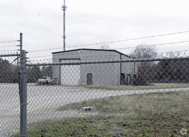
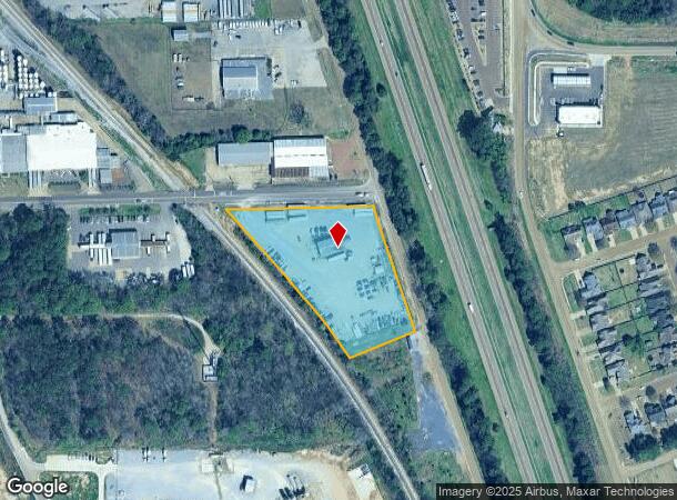
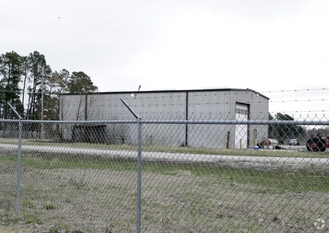
Property Record
2410 Magnolia Dr, Hernando, MS 38632
NEARBY LISTINGS FOR SALE OR LEASE
Property Detail
2410 Magnolia Dr
Memphis, TN-MS-AR
Pt N & E Of Rr
3074190000000300
PT N & E OF RR LOT A
Commercialnec
DeSoto
X
Mississippi
28033C0230H
a
2025
2.82 AC
2025
DeSoto
071124
Memphis
3,000 SF
DEMOGRAPHICS near 2410 Magnolia Dr
1 Mile
3 Mile
5 Mile
2024 Total Population
3,857
19,477
24,270
2029 Population
4,208
21,265
26,529
Pop Growth 2024-2029
+ 9.10%
+ 9.18%
+ 9.31%
Average Age
38
39
39
2024 Total Households
1,413
6,917
8,604
HH Growth 2024-2029
+ 9.06%
+ 9.17%
+ 9.27%
Median Household Inc
$58,486
$70,679
$77,803
Avg Household Size
2.70
2.70
2.70
2024 Avg HH Vehicles
2.00
2.00
2.00
Median Home Value
$288,377
$276,976
$279,793
Median Year Built
2000
1999
1999
Nearby Places
Map Layers
Map Styles
 Street
 Aerial
- Restaurants
- Banks
- Shops
- Fitness
- Groceries
PUBLIC TRANSPORTATION
AIRPORT
Memphis International
DRIVE
WALK
Distance
Memphis International
29 min
18.7 mi
Nearby Properties
Address
Land Use
TOTAL SIZE
Lot Size
Zoning
Address
Land Use
TOTAL SIZE
Lot Size
Zoning
19,367 SF
20.34 AC
PUD
Address
Land Use
TOTAL SIZE
Lot Size
Zoning
158,963 SF
20.07 AC
PUD
Address
Land Use
TOTAL SIZE
Lot Size
Zoning
120,095 SF
19.42 AC
C-2
Address
Land Use
TOTAL SIZE
Lot Size
Zoning
242,220 SF
27.54 AC
M-2
Address
Land Use
TOTAL SIZE
Lot Size
Zoning
13,533 SF
1.50 AC
PUD
Address
Land Use
TOTAL SIZE
Lot Size
Zoning
71,484 SF
6.45 AC
C-2
Address
Land Use
TOTAL SIZE
Lot Size
Zoning
37,622 SF
5.63 AC
PUD
Address
Land Use
TOTAL SIZE
Lot Size
Zoning
12,002 SF
1.15 AC
M-1
Address
Land Use
TOTAL SIZE
Lot Size
Zoning
18,556 SF
5.50 AC
C-2
Address
Land Use
TOTAL SIZE
Lot Size
Zoning
45,515 SF
2.60 AC
C-2
Address
Land Use
TOTAL SIZE
Lot Size
Zoning
55,903 SF
5.70 AC
C-4
Address
Land Use
TOTAL SIZE
Lot Size
Zoning
3.12 AC
PUD
Address
Land Use
TOTAL SIZE
Lot Size
Zoning
54,098 SF
9.27 AC
M-1
Address
Land Use
TOTAL SIZE
Lot Size
Zoning
53,623 SF
2.69 AC
C-2
Address
Land Use
TOTAL SIZE
Lot Size
Zoning
24,163 SF
1.97 AC
C-2
Address
Land Use
TOTAL SIZE
Lot Size
Zoning
45,789 SF
10 AC
M-2
Address
Land Use
TOTAL SIZE
Lot Size
Zoning
12,201 SF
3.44 AC
M-1
Address
Land Use
TOTAL SIZE
Lot Size
Zoning
100,000 SF
9.90 AC
M-2
Address
Land Use
TOTAL SIZE
Lot Size
Zoning
46,498 SF
8.26 AC
M-1
Address
Land Use
TOTAL SIZE
Lot Size
Zoning
20,386 SF
3.24 AC
C-4
Address
Land Use
TOTAL SIZE
Lot Size
Zoning
37,074 SF
5.46 AC
C-2
Address
Land Use
TOTAL SIZE
Lot Size
Zoning
44,973 SF
4 AC
M-2
Address
Land Use
TOTAL SIZE
Lot Size
Zoning
40,831 SF
6.11 AC
C-2
Address
Land Use
TOTAL SIZE
Lot Size
Zoning
8,076 SF
4.04 AC
C-2
Address
Land Use
TOTAL SIZE
Lot Size
Zoning
21,206 SF
1.25 AC
C-4
Address
Land Use
TOTAL SIZE
Lot Size
Zoning
32,495 SF
6.61 AC
RM-6
Address
Land Use
TOTAL SIZE
Lot Size
Zoning
9,450 SF
2.49 AC
C-2
Address
Land Use
TOTAL SIZE
Lot Size
Zoning
17,278 SF
1.73 AC
C-2
Address
Land Use
TOTAL SIZE
Lot Size
Zoning
63,226 SF
3 AC
M-1
Address
Land Use
TOTAL SIZE
Lot Size
Zoning
6,720 SF
1.40 AC
C-2
The World's #1 Commercial Real Estate Marketplace
Connect with us
© 2026 CoStar Group
The information above has been obtained from sources believed reliable. While we do not doubt its accuracy we have not verified it and make no guarantee, warranty or representation about it. It is your responsibility to independently confirm its accuracy and completeness. Any projections, opinions, assumptions, or estimates used are for example only and do not represent the current or future performance of the property. The value of this transaction to you depends on tax and other factors which should be evaluated by your tax, financial, and legal advisors. You and your advisors should conduct a careful, independent investigation of the property to determine to your satisfaction the suitability of the property for your needs.