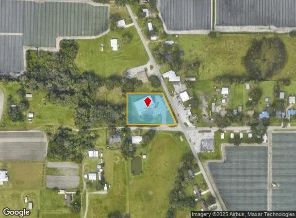
Property Record
2410 Medulla Rd, Plant City, FL 33566

NEARBY LISTINGS FOR SALE OR LEASE
Property Detail
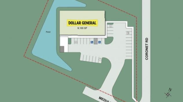
2410 Medulla Rd
Tampa-St. Petersburg-Clearwater, FL
Unplatted
U-02-29-22-ZZZ-000004-83570.0
S 251 FT OF THAT PART OF SW 1/4 OF SE 1/4 W OF RD
Storemultistory
Hillsborough
X
Florida
12057C0430H
83570
2024
1.55 AC
2024
Eastern Outlying
013002
Tampa/St Petersburg
9,171 SF
DEMOGRAPHICS near 2410 Medulla Rd
1 Mile
3 Mile
5 Mile
2024 Total Population
2,301
16,874
62,525
2029 Population
2,515
18,628
69,763
Pop Growth 2024-2029
+ 9.30%
+ 10.39%
+ 11.58%
Average Age
37
37
38
2024 Total Households
683
5,460
21,339
HH Growth 2024-2029
+ 9.52%
+ 10.73%
+ 11.81%
Median Household Inc
$59,218
$62,122
$65,943
Avg Household Size
3.10
2.90
2.80
2024 Avg HH Vehicles
2.00
2.00
2.00
Median Home Value
$215,909
$259,381
$255,730
Median Year Built
1990
1994
1989
Nearby Places
Map Layers
Map Styles
 Street
 Aerial
- Restaurants
- Banks
- Shops
- Fitness
- Groceries
PUBLIC TRANSPORTATION
AIRPORT
Tampa International
DRIVE
WALK
Distance
Tampa International
48 min
35.7 mi
Freight Ports
Port of Tampa Bay
DRIVE
WALK
Distance
Port of Tampa Bay
40 min
29.1 mi
SALE & LEASE HISTORY
LISTING DATE
SALE/LEASE

Oct 24, 2018
For Sale
Nearby Properties
Address
Land Use
TOTAL SIZE
Lot Size
Zoning
Address
Land Use
TOTAL SIZE
Lot Size
Zoning
711,568 SF
42.87 AC
PD
Address
Land Use
TOTAL SIZE
Lot Size
Zoning
805,336 SF
52.50 AC
I
Address
Land Use
TOTAL SIZE
Lot Size
Zoning
779,760 SF
67.03 AC
I
Address
Land Use
TOTAL SIZE
Lot Size
Zoning
519,942 SF
130.03 AC
I
Address
Land Use
TOTAL SIZE
Lot Size
Zoning
711,568 SF
43.33 AC
PD
Address
Land Use
TOTAL SIZE
Lot Size
Zoning
508,310 SF
37.85 AC
M-1A
Address
Land Use
TOTAL SIZE
Lot Size
Zoning
605,109 SF
141.96 AC
PD
Address
Land Use
TOTAL SIZE
Lot Size
Zoning
505,506 SF
50.60 AC
MU-R/C/I
Address
Land Use
TOTAL SIZE
Lot Size
Zoning
417,890 SF
14.59 AC
Address
Land Use
TOTAL SIZE
Lot Size
Zoning
387,165 SF
37 AC
I2
Address
Land Use
TOTAL SIZE
Lot Size
Zoning
415,389 SF
62.31 AC
MU-R/C/I
Address
Land Use
TOTAL SIZE
Lot Size
Zoning
220,510 SF
37.56 AC
I
Address
Land Use
TOTAL SIZE
Lot Size
Zoning
333,718 SF
28.99 AC
I
Address
Land Use
TOTAL SIZE
Lot Size
Zoning
296,496 SF
77.52 AC
P
Address
Land Use
TOTAL SIZE
Lot Size
Zoning
328,863 SF
38.87 AC
M-1A
Address
Land Use
TOTAL SIZE
Lot Size
Zoning
300,411 SF
18.77 AC
I
Address
Land Use
TOTAL SIZE
Lot Size
Zoning
297,907 SF
21.43 AC
M-1A
Address
Land Use
TOTAL SIZE
Lot Size
Zoning
492,180 SF
32.61 AC
PD
Address
Land Use
TOTAL SIZE
Lot Size
Zoning
22.41 AC
M-1A
Address
Land Use
TOTAL SIZE
Lot Size
Zoning
213,188 SF
16.10 AC
PD
Address
Land Use
TOTAL SIZE
Lot Size
Zoning
221,500 SF
19.54 AC
XX
Address
Land Use
TOTAL SIZE
Lot Size
Zoning
177,038 SF
16.95 AC
PD
Address
Land Use
TOTAL SIZE
Lot Size
Zoning
215,557 SF
13.27 AC
I
Address
Land Use
TOTAL SIZE
Lot Size
Zoning
202,712 SF
28.41 AC
C
Address
Land Use
TOTAL SIZE
Lot Size
Zoning
247,608 SF
25.84 AC
PD
Address
Land Use
TOTAL SIZE
Lot Size
Zoning
122,814 SF
17.18 AC
I
Address
Land Use
TOTAL SIZE
Lot Size
Zoning
200,200 SF
17.40 AC
XX
Address
Land Use
TOTAL SIZE
Lot Size
Zoning
154,237 SF
17.92 AC
C
Address
Land Use
TOTAL SIZE
Lot Size
Zoning
187,247 SF
10.19 AC
PD
Address
Land Use
TOTAL SIZE
Lot Size
Zoning
169,563 SF
12.27 AC
I
The World's #1 Commercial Real Estate Marketplace
Connect with us
© 2026 CoStar Group
The information above has been obtained from sources believed reliable. While we do not doubt its accuracy we have not verified it and make no guarantee, warranty or representation about it. It is your responsibility to independently confirm its accuracy and completeness. Any projections, opinions, assumptions, or estimates used are for example only and do not represent the current or future performance of the property. The value of this transaction to you depends on tax and other factors which should be evaluated by your tax, financial, and legal advisors. You and your advisors should conduct a careful, independent investigation of the property to determine to your satisfaction the suitability of the property for your needs.