Property Record
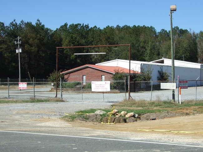
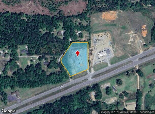
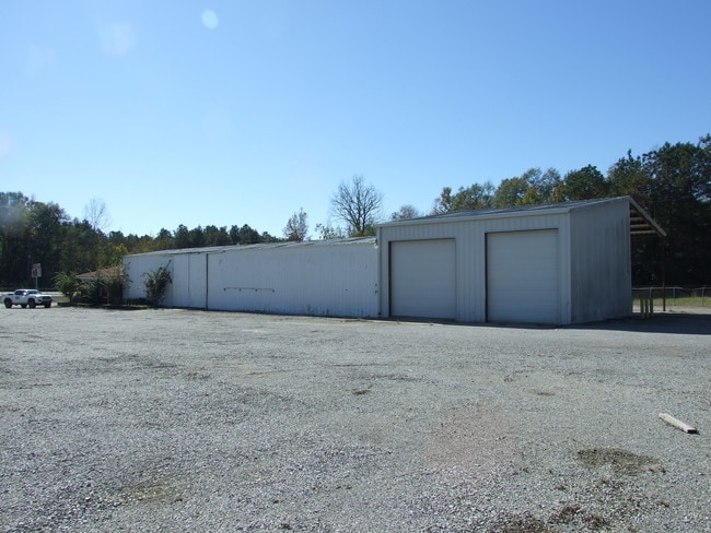
24100 Us Highway 80 W, Demopolis, AL 36732
NEARBY LISTINGS FOR SALE OR LEASE
Property Detail
24100 Us Highway 80 W
06-03-08-0-000-014-0010
To Pob
Autorepair
LOT SIZE: 250.9' X 450'(S) IRREG. OR 2.5 AC(C) BEG. ON N R/W US HWY 80 AT E LINE NE 1/4 OF NW 1/4 TH: SW 250.9' N'LY 450'(S)
X
Marengo
01119C0525D
Alabama
2025
2.50 AC
2024
Alabama South Area
973400
Other Market Areas
4,080 SF
DEMOGRAPHICS near 24100 Us Highway 80 W
1 Mile
3 Mile
5 Mile
2024 Total Population
73
376
3,423
2029 Population
68
356
3,255
Pop Growth 2024-2029
(6.85%)
(5.32%)
(4.91%)
Average Age
42
43
42
2024 Total Households
31
163
1,426
HH Growth 2024-2029
(6.45%)
(5.52%)
(4.56%)
Median Household Inc
$32,500
$35,278
$65,932
Avg Household Size
2.00
2.10
2.30
2024 Avg HH Vehicles
2.00
2.00
2.00
Median Home Value
$162,499
$154,545
$220,652
Median Year Built
1976
1977
1979
Nearby Places
Map Layers
Map Styles
 Street
 Aerial
- Restaurants
- Banks
- Shops
- Fitness
- Groceries
SALE & LEASE HISTORY
LISTING DATE
SALE/LEASE

Nov 08, 2017
For Sale
Jul 08, 2021
For Sale
Dec 26, 2023
For Sale
Dec 01, 2018
For Lease
Nearby Properties
Address
Land Use
TOTAL SIZE
Lot Size
Zoning
Address
Land Use
TOTAL SIZE
Lot Size
Zoning
10,431 SF
3 AC
Address
Land Use
TOTAL SIZE
Lot Size
Zoning
12,600 SF
68 AC
Address
Land Use
TOTAL SIZE
Lot Size
Zoning
Address
Land Use
TOTAL SIZE
Lot Size
Zoning
3,850 SF
6.50 AC
Address
Land Use
TOTAL SIZE
Lot Size
Zoning
1,628 SF
16 AC
Address
Land Use
TOTAL SIZE
Lot Size
Zoning
Address
Land Use
TOTAL SIZE
Lot Size
Zoning
1,800 SF
7.85 AC
Address
Land Use
TOTAL SIZE
Lot Size
Zoning
Address
Land Use
TOTAL SIZE
Lot Size
Zoning
599 AC
Address
Land Use
TOTAL SIZE
Lot Size
Zoning
4,084 SF
24 AC
Address
Land Use
TOTAL SIZE
Lot Size
Zoning
5,500 SF
1.90 AC
Address
Land Use
TOTAL SIZE
Lot Size
Zoning
Address
Land Use
TOTAL SIZE
Lot Size
Zoning
400 SF
20 AC
Address
Land Use
TOTAL SIZE
Lot Size
Zoning
Address
Land Use
TOTAL SIZE
Lot Size
Zoning
Address
Land Use
TOTAL SIZE
Lot Size
Zoning
269 AC
Address
Land Use
TOTAL SIZE
Lot Size
Zoning
295 AC
Address
Land Use
TOTAL SIZE
Lot Size
Zoning
Address
Land Use
TOTAL SIZE
Lot Size
Zoning
1,080 SF
4 AC
Address
Land Use
TOTAL SIZE
Lot Size
Zoning
2,880 SF
2.40 AC
Address
Land Use
TOTAL SIZE
Lot Size
Zoning
Address
Land Use
TOTAL SIZE
Lot Size
Zoning
Address
Land Use
TOTAL SIZE
Lot Size
Zoning
Address
Land Use
TOTAL SIZE
Lot Size
Zoning
Address
Land Use
TOTAL SIZE
Lot Size
Zoning
Address
Land Use
TOTAL SIZE
Lot Size
Zoning
165 AC
Address
Land Use
TOTAL SIZE
Lot Size
Zoning
Address
Land Use
TOTAL SIZE
Lot Size
Zoning
Address
Land Use
TOTAL SIZE
Lot Size
Zoning
The World's #1 Commercial Real Estate Marketplace
Connect with us
© 2026 CoStar Group
The information above has been obtained from sources believed reliable. While we do not doubt its accuracy we have not verified it and make no guarantee, warranty or representation about it. It is your responsibility to independently confirm its accuracy and completeness. Any projections, opinions, assumptions, or estimates used are for example only and do not represent the current or future performance of the property. The value of this transaction to you depends on tax and other factors which should be evaluated by your tax, financial, and legal advisors. You and your advisors should conduct a careful, independent investigation of the property to determine to your satisfaction the suitability of the property for your needs.