Property Record
2411 N Highway 17, Mount Pleasant, SC 29466
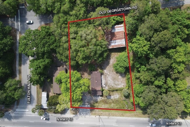

This Property Is For Sale
NEARBY LISTINGS FOR SALE OR LEASE
Property Detail
2411 N Highway 17
Charleston-North Charleston, SC
Brick Church
580-14-00-018
SUBDIVISION NAME -BRICK CHURCH DESCRIPTION -LT 11 SITE NAME -BOARS NEST RESTAURANT
Commercialnec
Charleston
X
South Carolina
45019C0535K
11
2025
0.53 AC
2024
East Islands/Mt Pleasant
004610
Charleston/N Charleston
858 SF
DEMOGRAPHICS near 2411 N Highway 17
1 Mile
3 Mile
5 Mile
2024 Total Population
4,141
33,511
86,428
2029 Population
4,373
34,891
91,999
Pop Growth 2024-2029
+ 5.60%
+ 4.12%
+ 6.45%
Average Age
41
42
42
2024 Total Households
1,667
13,858
34,738
HH Growth 2024-2029
+ 5.52%
+ 3.82%
+ 6.32%
Median Household Inc
$106,620
$97,592
$104,644
Avg Household Size
2.40
2.40
2.40
2024 Avg HH Vehicles
2.00
2.00
2.00
Median Home Value
$459,752
$482,409
$553,931
Median Year Built
1993
1996
1998
Nearby Places
Map Layers
Map Styles
 Street
 Aerial
- Restaurants
- Banks
- Shops
- Fitness
- Groceries
PUBLIC TRANSPORTATION
AIRPORT
Charleston AFB/International
DRIVE
WALK
Distance
Charleston AFB/International
31 min
19.9 mi
Freight Ports
Wando Welch Terminal
DRIVE
WALK
Distance
Wando Welch Terminal
9 min
4.6 mi
Nearby Properties
Address
Land Use
TOTAL SIZE
Lot Size
Zoning
Address
Land Use
TOTAL SIZE
Lot Size
Zoning
19.70 AC
Address
Land Use
TOTAL SIZE
Lot Size
Zoning
18,316 SF
14.16 AC
Address
Land Use
TOTAL SIZE
Lot Size
Zoning
6,572 SF
23.28 AC
Address
Land Use
TOTAL SIZE
Lot Size
Zoning
Address
Land Use
TOTAL SIZE
Lot Size
Zoning
37,472 SF
9.04 AC
Address
Land Use
TOTAL SIZE
Lot Size
Zoning
Address
Land Use
TOTAL SIZE
Lot Size
Zoning
70,052 SF
14.67 AC
Address
Land Use
TOTAL SIZE
Lot Size
Zoning
10,948 SF
1.94 AC
Address
Land Use
TOTAL SIZE
Lot Size
Zoning
24,836 SF
10.63 AC
Address
Land Use
TOTAL SIZE
Lot Size
Zoning
Address
Land Use
TOTAL SIZE
Lot Size
Zoning
Address
Land Use
TOTAL SIZE
Lot Size
Zoning
4,351 SF
29.03 AC
Address
Land Use
TOTAL SIZE
Lot Size
Zoning
3.76 AC
Address
Land Use
TOTAL SIZE
Lot Size
Zoning
63,836 SF
2.76 AC
Address
Land Use
TOTAL SIZE
Lot Size
Zoning
80,395 SF
15.24 AC
Address
Land Use
TOTAL SIZE
Lot Size
Zoning
Address
Land Use
TOTAL SIZE
Lot Size
Zoning
Address
Land Use
TOTAL SIZE
Lot Size
Zoning
Address
Land Use
TOTAL SIZE
Lot Size
Zoning
1,104 SF
13.70 AC
Address
Land Use
TOTAL SIZE
Lot Size
Zoning
864 SF
22.36 AC
Address
Land Use
TOTAL SIZE
Lot Size
Zoning
Address
Land Use
TOTAL SIZE
Lot Size
Zoning
Address
Land Use
TOTAL SIZE
Lot Size
Zoning
56,648 SF
11.39 AC
Address
Land Use
TOTAL SIZE
Lot Size
Zoning
60,701 SF
9.97 AC
Address
Land Use
TOTAL SIZE
Lot Size
Zoning
12.60 AC
Address
Land Use
TOTAL SIZE
Lot Size
Zoning
6.98 AC
Address
Land Use
TOTAL SIZE
Lot Size
Zoning
30,495 SF
8.73 AC
Address
Land Use
TOTAL SIZE
Lot Size
Zoning
45,969 SF
10.76 AC
Address
Land Use
TOTAL SIZE
Lot Size
Zoning
Address
Land Use
TOTAL SIZE
Lot Size
Zoning
17,747 SF
1.59 AC
The World's #1 Commercial Real Estate Marketplace
Connect with us
© 2025 CoStar Group
The information above has been obtained from sources believed reliable. While we do not doubt its accuracy we have not verified it and make no guarantee, warranty or representation about it. It is your responsibility to independently confirm its accuracy and completeness. Any projections, opinions, assumptions, or estimates used are for example only and do not represent the current or future performance of the property. The value of this transaction to you depends on tax and other factors which should be evaluated by your tax, financial, and legal advisors. You and your advisors should conduct a careful, independent investigation of the property to determine to your satisfaction the suitability of the property for your needs.