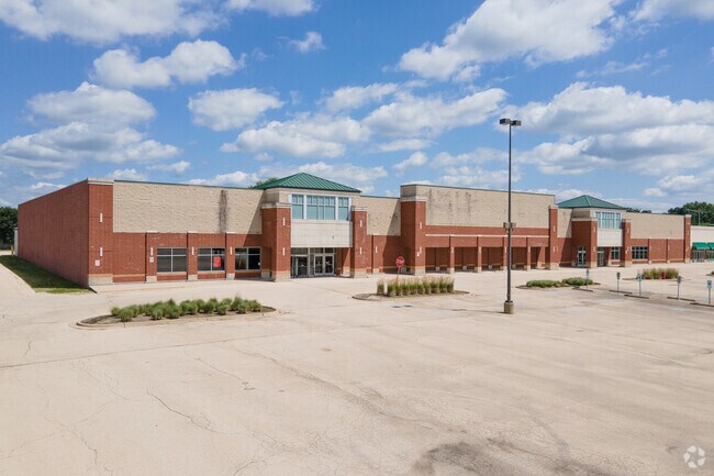
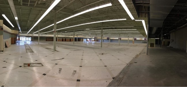
Property Record
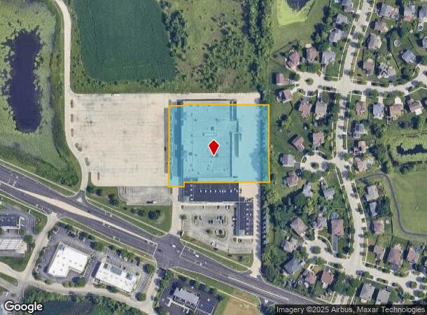
2411 Randall Rd, Carpentersville, IL 60110

NEARBY LISTINGS FOR SALE OR LEASE
Property Detail
2411 Randall Rd
Chicago
Randall Carpentersville Sub
Chicago-Naperville-Elgin, IL-IN-WI
2411 RANDALL CARPENTERSVILLE SUB - LT 8
03-08-351-010
Kane
Commercialnec
Illinois
2024
8
2024
Far Northwest
850105
DEMOGRAPHICS near 2411 Randall Rd
1 Mile
3 Mile
5 Mile
2024 Total Population
8,012
36,025
130,831
2029 Population
8,012
35,998
130,630
Pop Growth 2024-2029
0.00%
(0.07%)
(0.15%)
Average Age
38
40
39
2024 Total Households
2,604
12,504
45,058
HH Growth 2024-2029
(0.12%)
(0.11%)
(0.19%)
Median Household Inc
$110,992
$117,633
$94,706
Avg Household Size
3.00
2.90
2.90
2024 Avg HH Vehicles
2.00
2.00
2.00
Median Home Value
$291,531
$306,391
$259,785
Median Year Built
1999
1995
1991
Nearby Places
- Restaurants
- Banks
- Shops
- Fitness
- Groceries
PUBLIC TRANSPORTATION
COMMUTER RAIL
Big Timber Road Station (Milwaukee District West Line - Northeast Illinois Regional Commuter Railroad (Metra))
DRIVE
WALK
Distance
Big Timber Road Station (Milwaukee District West Line - Northeast Illinois Regional Commuter Railroad (Metra))
10 min
5.1 mi
Elgin Station (Milwaukee District West Line - Northeast Illinois Regional Commuter Railroad (Metra))
DRIVE
WALK
Distance
Elgin Station (Milwaukee District West Line - Northeast Illinois Regional Commuter Railroad (Metra))
15 min
8.1 mi
AIRPORT
Chicago O'Hare International
DRIVE
WALK
Distance
Chicago O'Hare International
40 min
31.6 mi
SALE & LEASE HISTORY
LISTING DATE
SALE/LEASE

Nov 14, 2018
For Lease
Jul 31, 2017
For Lease
Apr 03, 2017
For Lease
Nearby Properties
Address
Land Use
TOTAL SIZE
Lot Size
Zoning
Address
Land Use
TOTAL SIZE
Lot Size
Zoning
Address
Land Use
TOTAL SIZE
Lot Size
Zoning
10.88 AC
Address
Land Use
TOTAL SIZE
Lot Size
Zoning
547,668 SF
30.17 AC
Address
Land Use
TOTAL SIZE
Lot Size
Zoning
0.90 AC
Address
Land Use
TOTAL SIZE
Lot Size
Zoning
18.73 AC
Address
Land Use
TOTAL SIZE
Lot Size
Zoning
411,943 SF
17 AC
Address
Land Use
TOTAL SIZE
Lot Size
Zoning
20.02 AC
Address
Land Use
TOTAL SIZE
Lot Size
Zoning
20.33 AC
Address
Land Use
TOTAL SIZE
Lot Size
Zoning
22.04 AC
Address
Land Use
TOTAL SIZE
Lot Size
Zoning
307,150 SF
29.72 AC
Address
Land Use
TOTAL SIZE
Lot Size
Zoning
20.35 AC
Address
Land Use
TOTAL SIZE
Lot Size
Zoning
Address
Land Use
TOTAL SIZE
Lot Size
Zoning
7.92 AC
Address
Land Use
TOTAL SIZE
Lot Size
Zoning
173,563 SF
0.48 AC
Address
Land Use
TOTAL SIZE
Lot Size
Zoning
342,700 SF
19 AC
Address
Land Use
TOTAL SIZE
Lot Size
Zoning
250,000 SF
13.22 AC
Address
Land Use
TOTAL SIZE
Lot Size
Zoning
54,472 SF
21 AC
Address
Land Use
TOTAL SIZE
Lot Size
Zoning
250,530 SF
12 AC
Address
Land Use
TOTAL SIZE
Lot Size
Zoning
251,200 SF
13.99 AC
Address
Land Use
TOTAL SIZE
Lot Size
Zoning
11.16 AC
Address
Land Use
TOTAL SIZE
Lot Size
Zoning
13.53 AC
Address
Land Use
TOTAL SIZE
Lot Size
Zoning
Address
Land Use
TOTAL SIZE
Lot Size
Zoning
Address
Land Use
TOTAL SIZE
Lot Size
Zoning
1.03 AC
Address
Land Use
TOTAL SIZE
Lot Size
Zoning
229,356 SF
12 AC
Address
Land Use
TOTAL SIZE
Lot Size
Zoning
219,245 SF
13 AC
Address
Land Use
TOTAL SIZE
Lot Size
Zoning
11.91 AC
Address
Land Use
TOTAL SIZE
Lot Size
Zoning
6.48 AC
Address
Land Use
TOTAL SIZE
Lot Size
Zoning
154,563 SF
0.80 AC
The World's #1 Commercial Real Estate Marketplace
Connect with us
© 2025 CoStar Group
The information above has been obtained from sources believed reliable. While we do not doubt its accuracy we have not verified it and make no guarantee, warranty or representation about it. It is your responsibility to independently confirm its accuracy and completeness. Any projections, opinions, assumptions, or estimates used are for example only and do not represent the current or future performance of the property. The value of this transaction to you depends on tax and other factors which should be evaluated by your tax, financial, and legal advisors. You and your advisors should conduct a careful, independent investigation of the property to determine to your satisfaction the suitability of the property for your needs.