Property Record
24116 Ennis Mill Rd, Windsor, VA 23487
NEARBY LISTINGS FOR SALE OR LEASE
-
-
View all Windsor listings for sale on LoopNet.com
Property Detail
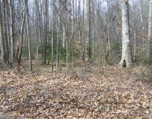
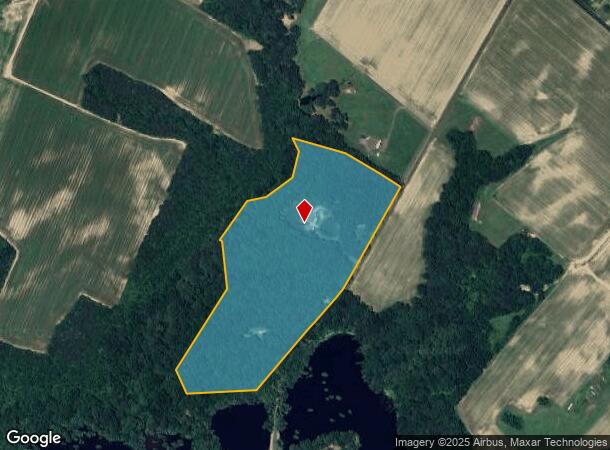
24116 Ennis Mill Rd
55-01-037A
AT INDICA PLAT 2-201-11 I#230002545
Agriculturalland
Isle of Wight
A
Virginia
51093C0275E
25.40 AC
2025
Isle Of Wight
2025
Hampton Roads
280300
Virginia Beach-Norfolk-Newport News, VA-NC
3,913 SF
DEMOGRAPHICS near 24116 Ennis Mill Rd
1 Mile
3 Mile
5 Mile
2024 Total Population
168
2,182
8,367
2029 Population
184
2,392
9,194
Pop Growth 2024-2029
+ 9.52%
+ 9.62%
+ 9.88%
Average Age
43
44
45
2024 Total Households
66
854
3,258
HH Growth 2024-2029
+ 9.09%
+ 9.72%
+ 10.10%
Median Household Inc
$71,249
$85,051
$81,707
Avg Household Size
2.40
2.50
2.50
2024 Avg HH Vehicles
2.00
2.00
2.00
Median Home Value
$250,000
$282,270
$309,248
Median Year Built
1981
1982
1987
Nearby Places
Map Layers
Map Styles
 Street
 Aerial
- Restaurants
- Banks
- Shops
- Fitness
- Groceries
PUBLIC TRANSPORTATION
AIRPORT
Newport News/Williamsburg International
DRIVE
WALK
Distance
Newport News/Williamsburg International
53 min
32.7 mi
Norfolk International
DRIVE
WALK
Distance
Norfolk International
49 min
33.9 mi
Freight Ports
Virginia Port Authority - Newport News
DRIVE
WALK
Distance
Virginia Port Authority - Newport News
41 min
26.0 mi
Nearby Properties
Address
Land Use
TOTAL SIZE
Lot Size
Zoning
Address
Land Use
TOTAL SIZE
Lot Size
Zoning
1,023,750 SF
81.85 AC
06
Address
Land Use
TOTAL SIZE
Lot Size
Zoning
329,881 SF
64.15 AC
06
Address
Land Use
TOTAL SIZE
Lot Size
Zoning
302,316 SF
31.09 AC
06
Address
Land Use
TOTAL SIZE
Lot Size
Zoning
1,560 SF
73.52 AC
RURAL ESTA
Address
Land Use
TOTAL SIZE
Lot Size
Zoning
71,160 SF
19.06 AC
AGRICULTUR
Address
Land Use
TOTAL SIZE
Lot Size
Zoning
37,328 SF
6.31 AC
TOWN
Address
Land Use
TOTAL SIZE
Lot Size
Zoning
7,776 SF
1.40 AC
TOWN
Address
Land Use
TOTAL SIZE
Lot Size
Zoning
12,063 SF
2 AC
TOWN
Address
Land Use
TOTAL SIZE
Lot Size
Zoning
6,446 SF
21.27 AC
RURAL ESTA
Address
Land Use
TOTAL SIZE
Lot Size
Zoning
3,750 SF
12.50 AC
01
Address
Land Use
TOTAL SIZE
Lot Size
Zoning
15,500 SF
1.92 AC
TOWN
Address
Land Use
TOTAL SIZE
Lot Size
Zoning
14,910 SF
1.31 AC
TOWN
Address
Land Use
TOTAL SIZE
Lot Size
Zoning
6,369 SF
30 AC
RAC
Address
Land Use
TOTAL SIZE
Lot Size
Zoning
6,606 SF
1.22 AC
TOWN
Address
Land Use
TOTAL SIZE
Lot Size
Zoning
6,776 SF
2.23 AC
TOWN
Address
Land Use
TOTAL SIZE
Lot Size
Zoning
10,850 SF
1.14 AC
TOWN
Address
Land Use
TOTAL SIZE
Lot Size
Zoning
0.53 AC
GC
Address
Land Use
TOTAL SIZE
Lot Size
Zoning
1,788 SF
69.89 AC
RAC
Address
Land Use
TOTAL SIZE
Lot Size
Zoning
2,910 SF
140.57 AC
RAC
Address
Land Use
TOTAL SIZE
Lot Size
Zoning
Address
Land Use
TOTAL SIZE
Lot Size
Zoning
3,221 SF
42.36 AC
RURAL ESTA
Address
Land Use
TOTAL SIZE
Lot Size
Zoning
22,044 SF
2.17 AC
AGRICULTUR
Address
Land Use
TOTAL SIZE
Lot Size
Zoning
3,868 SF
60.92 AC
AGRICULTUR
Address
Land Use
TOTAL SIZE
Lot Size
Zoning
1,488 SF
6.38 AC
TOWN
Address
Land Use
TOTAL SIZE
Lot Size
Zoning
5.97 AC
01
Address
Land Use
TOTAL SIZE
Lot Size
Zoning
2,284 SF
192.27 AC
RAC
Address
Land Use
TOTAL SIZE
Lot Size
Zoning
2,448 SF
21.83 AC
RAC
The World's #1 Commercial Real Estate Marketplace
Connect with us
© 2025 CoStar Group
The information above has been obtained from sources believed reliable. While we do not doubt its accuracy we have not verified it and make no guarantee, warranty or representation about it. It is your responsibility to independently confirm its accuracy and completeness. Any projections, opinions, assumptions, or estimates used are for example only and do not represent the current or future performance of the property. The value of this transaction to you depends on tax and other factors which should be evaluated by your tax, financial, and legal advisors. You and your advisors should conduct a careful, independent investigation of the property to determine to your satisfaction the suitability of the property for your needs.