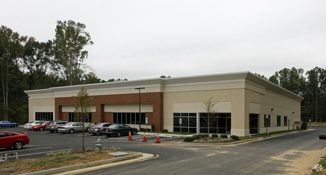
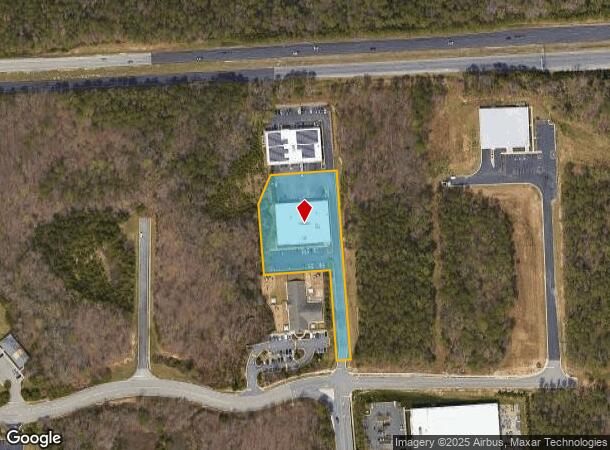
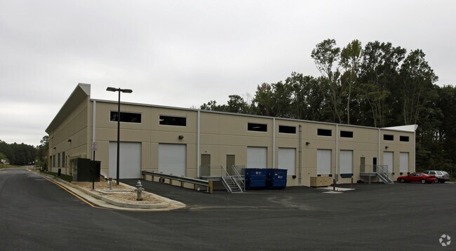
Property Record
2412 Pari Way, Midlothian, VA 23112

NEARBY LISTINGS FOR SALE OR LEASE
-
-
View all Midlothian listings for sale on LoopNet.com
Property Detail
2412 Pari Way
730-69-23-70-400-000
N Of Tredegar Lake Py Par B
Multipleuses
N OF TREDEGAR LAKE PY PAR B
X
Chesterfield
51145C0300C
Virginia
2025
2 AC
2025
Rt 288 Corridor
100937
Richmond VA
20,000 SF
Richmond, VA
DEMOGRAPHICS near 2412 Pari Way
1 Mile
3 Mile
5 Mile
2024 Total Population
3,683
52,780
136,468
2029 Population
4,006
57,879
149,824
Pop Growth 2024-2029
+ 8.77%
+ 9.66%
+ 9.79%
Average Age
39
40
40
2024 Total Households
1,448
20,038
51,231
HH Growth 2024-2029
+ 8.91%
+ 9.72%
+ 9.87%
Median Household Inc
$93,128
$102,626
$98,726
Avg Household Size
2.50
2.60
2.60
2024 Avg HH Vehicles
2.00
2.00
2.00
Median Home Value
$309,981
$342,475
$337,878
Median Year Built
1985
1993
1992
Nearby Places
Map Layers
Map Styles
 Street
 Aerial
- Restaurants
- Banks
- Shops
- Fitness
- Groceries
PUBLIC TRANSPORTATION
AIRPORT
Richmond International
DRIVE
WALK
Distance
Richmond International
39 min
26.2 mi
Freight Ports
Virginia Port Authority - Richmond
DRIVE
WALK
Distance
Virginia Port Authority - Richmond
31 min
15.7 mi
Nearby Properties
Address
Land Use
TOTAL SIZE
Lot Size
Zoning
Address
Land Use
TOTAL SIZE
Lot Size
Zoning
88,520 SF
28.29 AC
C3 - COMMU
Address
Land Use
TOTAL SIZE
Lot Size
Zoning
101,438 SF
63.19 AC
A - AGRICU
Address
Land Use
TOTAL SIZE
Lot Size
Zoning
5,720 SF
117.22 AC
R9 - SINGL
Address
Land Use
TOTAL SIZE
Lot Size
Zoning
5,922 SF
17.83 AC
RMF - RES,
Address
Land Use
TOTAL SIZE
Lot Size
Zoning
98,232 SF
24.69 AC
R9 - SINGL
Address
Land Use
TOTAL SIZE
Lot Size
Zoning
100 SF
17.82 AC
R7 - SINGL
Address
Land Use
TOTAL SIZE
Lot Size
Zoning
161,600 SF
18.40 AC
R7 - SINGL
Address
Land Use
TOTAL SIZE
Lot Size
Zoning
108,805 SF
21.09 AC
RMF - RES,
Address
Land Use
TOTAL SIZE
Lot Size
Zoning
136,718 SF
30.88 AC
RMF - RES,
Address
Land Use
TOTAL SIZE
Lot Size
Zoning
236,243 SF
90.17 AC
R9 - SINGL
Address
Land Use
TOTAL SIZE
Lot Size
Zoning
241,433 SF
68.39 AC
R15 - SING
Address
Land Use
TOTAL SIZE
Lot Size
Zoning
72,417 SF
11.76 AC
R7 - SINGL
Address
Land Use
TOTAL SIZE
Lot Size
Zoning
89,300 SF
32.90 AC
O2 - CORP
Address
Land Use
TOTAL SIZE
Lot Size
Zoning
29.24 AC
O2 - CORP
Address
Land Use
TOTAL SIZE
Lot Size
Zoning
174,840 SF
21.13 AC
R7 - SINGL
Address
Land Use
TOTAL SIZE
Lot Size
Zoning
113,384 SF
15.89 AC
R7 - SINGL
Address
Land Use
TOTAL SIZE
Lot Size
Zoning
99,934 SF
81.69 AC
A - AGRICU
Address
Land Use
TOTAL SIZE
Lot Size
Zoning
100 SF
15 AC
O2 - CORP
Address
Land Use
TOTAL SIZE
Lot Size
Zoning
23,256 SF
21.92 AC
C4 - REGIO
Address
Land Use
TOTAL SIZE
Lot Size
Zoning
220,845 SF
8.36 AC
I1 - LT IN
Address
Land Use
TOTAL SIZE
Lot Size
Zoning
218,108 SF
20.38 AC
C3 - COMMU
Address
Land Use
TOTAL SIZE
Lot Size
Zoning
97,740 SF
20.97 AC
R7 - SINGL
Address
Land Use
TOTAL SIZE
Lot Size
Zoning
116,542 SF
38.82 AC
R7 - SINGL
Address
Land Use
TOTAL SIZE
Lot Size
Zoning
5,680 SF
6.75 AC
C2 - NBHD
Address
Land Use
TOTAL SIZE
Lot Size
Zoning
310.29 AC
C3 - COMMU
Address
Land Use
TOTAL SIZE
Lot Size
Zoning
102,180 SF
13.97 AC
C4 - REGIO
Address
Land Use
TOTAL SIZE
Lot Size
Zoning
30,000 SF
11.96 AC
C4 - REGIO
Address
Land Use
TOTAL SIZE
Lot Size
Zoning
34,063 SF
4.18 AC
C5 - GEN B
Address
Land Use
TOTAL SIZE
Lot Size
Zoning
64,000 SF
17.56 AC
A - AGRICU
Address
Land Use
TOTAL SIZE
Lot Size
Zoning
13,310 SF
5.52 AC
C3 - COMMU
The World's #1 Commercial Real Estate Marketplace
Connect with us
© 2025 CoStar Group
The information above has been obtained from sources believed reliable. While we do not doubt its accuracy we have not verified it and make no guarantee, warranty or representation about it. It is your responsibility to independently confirm its accuracy and completeness. Any projections, opinions, assumptions, or estimates used are for example only and do not represent the current or future performance of the property. The value of this transaction to you depends on tax and other factors which should be evaluated by your tax, financial, and legal advisors. You and your advisors should conduct a careful, independent investigation of the property to determine to your satisfaction the suitability of the property for your needs.