Property Record
2412 Richcreek Rd, Austin, TX 78757
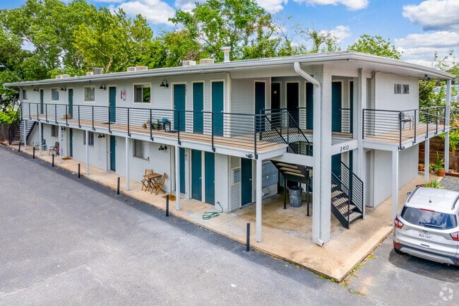


Property Detail
2412 Richcreek Rd
Austin-Round Rock-San Marcos, TX
LOT 2A RESUB OF LT 2 BLK R ALLANDALE PARK SEC 5
239128
Travis
Multifamilydwelling
Texas
B and X Area of moderate flood hazard, usually the area between the limits of the 100-year and 500-year floods.
2a,2
2025
0.27 AC
2025
Allandale
001501
Austin
6,120 SF
NEARBY LISTINGS FOR SALE OR LEASE
DEMOGRAPHICS near 2412 Richcreek Rd
1 mile
3 mile
5 mile
2025 Total Population
16,564
148,172
349,516
2030 Population
17,694
155,112
365,870
Pop Growth 2025-2030
+ 6.82%
+ 4.68%
+ 4.68%
Average Age
40
38
37
2025 Total Households
8,029
67,335
154,491
HH Growth 2025-2030
+ 8.12%
+ 5.51%
+ 5.49%
Median Household Inc
$100,664
$79,910
$83,604
Avg Household Size
2.00
2.10
2.10
2025 Avg HH Vehicles
2.00
2.00
2.00
Median Home Value
$750,337
$741,324
$738,317
Median Year Built
1973
1980
1986
Nearby Places
Map Layers
Map Styles
 Street
 Aerial
Layers
 Traffic
 Biking
Places
Listings with unknown addresses are not visible on the map
- Restaurants
- Banks
- Shops
- Fitness
- Groceries
PUBLIC TRANSPORTATION
COMMUTER RAIL
Austin (Texas Eagle - Amtrak)
Drive
Walk
Distance
Austin (Texas Eagle - Amtrak)
14 min
7.7 mi
AIRPORT
Austin-Bergstrom International
Drive
Walk
Distance
Austin-Bergstrom International
30 min
19.0 mi
Freight Ports
Calhoun Port
Drive
Walk
Distance
Calhoun Port
195 min
162.4 mi
SALE & LEASE HISTORY
LISTING DATE
SALE/LEASE

Jul 31, 2018
For Sale
Feb 25, 2020
For Sale
Nearby Properties
Address
Land Use
TOTAL SIZE
Lot Size
Zoning
Address
Land Use
TOTAL SIZE
Lot Size
Zoning
230.30 AC
Address
Land Use
TOTAL SIZE
Lot Size
Zoning
74.69 AC
Address
Land Use
TOTAL SIZE
Lot Size
Zoning
614,532 SF
66.07 AC
Address
Land Use
TOTAL SIZE
Lot Size
Zoning
1,234 SF
96.75 AC
Address
Land Use
TOTAL SIZE
Lot Size
Zoning
73.48 AC
Address
Land Use
TOTAL SIZE
Lot Size
Zoning
510,500 SF
9.26 AC
Address
Land Use
TOTAL SIZE
Lot Size
Zoning
Address
Land Use
TOTAL SIZE
Lot Size
Zoning
480,823 SF
18.46 AC
Address
Land Use
TOTAL SIZE
Lot Size
Zoning
354,008 SF
39.99 AC
Address
Land Use
TOTAL SIZE
Lot Size
Zoning
340,785 SF
1.89 AC
Address
Land Use
TOTAL SIZE
Lot Size
Zoning
346,319 SF
6.53 AC
Address
Land Use
TOTAL SIZE
Lot Size
Zoning
300,616 SF
3.95 AC
Address
Land Use
TOTAL SIZE
Lot Size
Zoning
45 AC
Address
Land Use
TOTAL SIZE
Lot Size
Zoning
303,622 SF
5.21 AC
Address
Land Use
TOTAL SIZE
Lot Size
Zoning
425,200 SF
2.49 AC
Address
Land Use
TOTAL SIZE
Lot Size
Zoning
314,319 SF
5.97 AC
Address
Land Use
TOTAL SIZE
Lot Size
Zoning
45.78 AC
Address
Land Use
TOTAL SIZE
Lot Size
Zoning
365,130 SF
18.15 AC
Address
Land Use
TOTAL SIZE
Lot Size
Zoning
286,276 SF
4.53 AC
Address
Land Use
TOTAL SIZE
Lot Size
Zoning
274,228 SF
4.95 AC
Address
Land Use
TOTAL SIZE
Lot Size
Zoning
276,772 SF
4.68 AC
Address
Land Use
TOTAL SIZE
Lot Size
Zoning
32.82 AC
Address
Land Use
TOTAL SIZE
Lot Size
Zoning
39.26 AC
Address
Land Use
TOTAL SIZE
Lot Size
Zoning
467,647 SF
3.54 AC
Address
Land Use
TOTAL SIZE
Lot Size
Zoning
465,808 SF
9.74 AC
Address
Land Use
TOTAL SIZE
Lot Size
Zoning
227,700 SF
3.97 AC
Address
Land Use
TOTAL SIZE
Lot Size
Zoning
299,957 SF
22.02 AC
Address
Land Use
TOTAL SIZE
Lot Size
Zoning
332,202 SF
31.81 AC
Address
Land Use
TOTAL SIZE
Lot Size
Zoning
16.79 AC
Address
Land Use
TOTAL SIZE
Lot Size
Zoning
18.45 AC
The World's #1 Commercial Real Estate Marketplace
Connect with us
© 2026 CoStar Group
The information above has been obtained from sources believed reliable. While we do not doubt its accuracy we have not verified it and make no guarantee, warranty or representation about it. It is your responsibility to independently confirm its accuracy and completeness. Any projections, opinions, assumptions, or estimates used are for example only and do not represent the current or future performance of the property. The value of this transaction to you depends on tax and other factors which should be evaluated by your tax, financial, and legal advisors. You and your advisors should conduct a careful, independent investigation of the property to determine to your satisfaction the suitability of the property for your needs.