Property Record
2412 S Preston St, Louisville, KY 40217


NEARBY LISTINGS FOR SALE OR LEASE
Property Detail
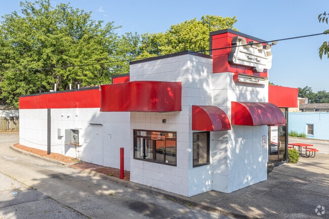
2412 S Preston St
083B02360000
.52 AC PRESTON BET HARRISON PKY DR
Restaurantbuilding
Jefferson
X
Kentucky
21111C0058F
0.52 AC
2025
Old Louisville
2025
Louisville
007102
Louisville-Jefferson County, KY-IN
1,552 SF
DEMOGRAPHICS near 2412 S Preston St
1 Mile
3 Mile
5 Mile
2024 Total Population
11,745
113,560
268,252
2029 Population
11,441
112,604
267,125
Pop Growth 2024-2029
(2.59%)
(0.84%)
(0.42%)
Average Age
39
38
39
2024 Total Households
5,770
52,464
117,550
HH Growth 2024-2029
(2.82%)
(0.77%)
(0.38%)
Median Household Inc
$62,210
$44,681
$44,996
Avg Household Size
1.90
2.00
2.10
2024 Avg HH Vehicles
2.00
1.00
1.00
Median Home Value
$207,341
$201,670
$174,722
Median Year Built
1947
1948
1953
Nearby Places
Map Layers
Map Styles
 Street
 Aerial
- Restaurants
- Banks
- Shops
- Fitness
- Groceries
SALE & LEASE HISTORY
LISTING DATE
SALE/LEASE

Sep 23, 2016
For Sale
Mar 14, 2023
For Lease
Mar 02, 2023
For Lease
Jul 24, 2023
For Sale
Nearby Properties
Address
Land Use
TOTAL SIZE
Lot Size
Zoning
Address
Land Use
TOTAL SIZE
Lot Size
Zoning
42,228 SF
144.63 AC
R5-RESIDEN
Address
Land Use
TOTAL SIZE
Lot Size
Zoning
Address
Land Use
TOTAL SIZE
Lot Size
Zoning
211,050 SF
Address
Land Use
TOTAL SIZE
Lot Size
Zoning
5.40 AC
Address
Land Use
TOTAL SIZE
Lot Size
Zoning
572,868 SF
1.57 AC
Address
Land Use
TOTAL SIZE
Lot Size
Zoning
106,330 SF
9.44 AC
M3-INDUSTR
Address
Land Use
TOTAL SIZE
Lot Size
Zoning
Address
Land Use
TOTAL SIZE
Lot Size
Zoning
85,882 SF
80.13 AC
R1-RESIDEN
Address
Land Use
TOTAL SIZE
Lot Size
Zoning
17,916 SF
21.76 AC
EZ1-ENTERP
Address
Land Use
TOTAL SIZE
Lot Size
Zoning
4,337 SF
3.71 AC
(C2)COMMER
Address
Land Use
TOTAL SIZE
Lot Size
Zoning
1,584 SF
4.71 AC
R7-RESIDEN
Address
Land Use
TOTAL SIZE
Lot Size
Zoning
260,488 SF
8.07 AC
EZ1-ENTERP
Address
Land Use
TOTAL SIZE
Lot Size
Zoning
Address
Land Use
TOTAL SIZE
Lot Size
Zoning
21,767 SF
1.47 AC
EZ1-ENTERP
Address
Land Use
TOTAL SIZE
Lot Size
Zoning
549,563 SF
26.13 AC
OTF-OFFICE
Address
Land Use
TOTAL SIZE
Lot Size
Zoning
304,295 SF
0.60 AC
C3-CENTRAL
Address
Land Use
TOTAL SIZE
Lot Size
Zoning
50,946 SF
2.66 AC
(CM)COMMER
Address
Land Use
TOTAL SIZE
Lot Size
Zoning
34,067 SF
0.84 AC
C3-CENTRAL
Address
Land Use
TOTAL SIZE
Lot Size
Zoning
59,648 SF
1.66 AC
OR3-OFFICE
Address
Land Use
TOTAL SIZE
Lot Size
Zoning
12.69 AC
Address
Land Use
TOTAL SIZE
Lot Size
Zoning
228,447 SF
7.70 AC
M2-INDUSTR
Address
Land Use
TOTAL SIZE
Lot Size
Zoning
58,935 SF
1.92 AC
TNZD-TRADI
Address
Land Use
TOTAL SIZE
Lot Size
Zoning
398,435 SF
9.93 AC
Address
Land Use
TOTAL SIZE
Lot Size
Zoning
6.75 AC
M2-INDUSTR
Address
Land Use
TOTAL SIZE
Lot Size
Zoning
248,323 SF
1 AC
C3-CENTRAL
Address
Land Use
TOTAL SIZE
Lot Size
Zoning
19.50 AC
Address
Land Use
TOTAL SIZE
Lot Size
Zoning
6,254 SF
1.48 AC
C2-COMMERC
Address
Land Use
TOTAL SIZE
Lot Size
Zoning
383,875 SF
1.31 AC
C3-CENTRAL
Address
Land Use
TOTAL SIZE
Lot Size
Zoning
7,026 SF
0.21 AC
C3-CENTRAL
Address
Land Use
TOTAL SIZE
Lot Size
Zoning
201,329 SF
1.99 AC
C2-COMMERC
The World's #1 Commercial Real Estate Marketplace
Connect with us
© 2026 CoStar Group
The information above has been obtained from sources believed reliable. While we do not doubt its accuracy we have not verified it and make no guarantee, warranty or representation about it. It is your responsibility to independently confirm its accuracy and completeness. Any projections, opinions, assumptions, or estimates used are for example only and do not represent the current or future performance of the property. The value of this transaction to you depends on tax and other factors which should be evaluated by your tax, financial, and legal advisors. You and your advisors should conduct a careful, independent investigation of the property to determine to your satisfaction the suitability of the property for your needs.