Property Record
24135 W Interstate 10, San Antonio, TX 78257
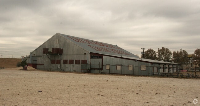

Property Detail
24135 W Interstate 10
San Antonio-New Braunfels, TX
NCB 34732E BLK 1 LOT N IRR 252.86 FT OF 10 (1.627 AC) (LEON SPRINGS DEVELOPMENT SUB IH 10 W/DOMINION ANNEXATN) 2024- RESURVEYED PID 1053956 TO MATCH DEEDED ACREAGE PER 20230216364 (1.627 AC) EXE 11-24-2023. (CR-62071). JF/GIS/5-8-2024.
34732-501-0101
BEXAR
Commercialnec
Texas
AE The base floodplain where base flood elevations are provided. AE Zones are now used on new format FIRMs instead of A1-A30 Zones.
n
2025
1.63 AC
2025
Far Northwest
191807
San Antonio
18,258 SF
NEARBY LISTINGS FOR SALE OR LEASE
DEMOGRAPHICS near 24135 W Interstate 10
1 mile
3 mile
5 mile
2025 Total Population
6,387
31,492
63,710
2030 Population
6,791
33,624
68,325
Pop Growth 2025-2030
+ 6.33%
+ 6.77%
+ 7.24%
Average Age
40
39
38
2025 Total Households
2,295
11,504
24,489
HH Growth 2025-2030
+ 6.67%
+ 7.04%
+ 7.55%
Median Household Inc
$110,881
$133,690
$122,673
Avg Household Size
2.70
2.70
2.60
2025 Avg HH Vehicles
2.00
2.00
2.00
Median Home Value
$500,968
$517,063
$520,816
Median Year Built
2008
2010
2010
Nearby Places
Map Layers
Map Styles
 Street
 Aerial
Layers
 Traffic
 Biking
Places
Listings with unknown addresses are not visible on the map
- Restaurants
- Banks
- Shops
- Fitness
- Groceries
PUBLIC TRANSPORTATION
AIRPORT
San Antonio International
Drive
Walk
Distance
San Antonio International
19 min
17.9 mi
Freight Ports
Calhoun Port
Drive
Walk
Distance
Calhoun Port
1 min
142.6 mi
Nearby Properties
Address
Land Use
TOTAL SIZE
Lot Size
Zoning
Address
Land Use
TOTAL SIZE
Lot Size
Zoning
Address
Land Use
TOTAL SIZE
Lot Size
Zoning
375,702 SF
10 AC
Address
Land Use
TOTAL SIZE
Lot Size
Zoning
361,559 SF
20 AC
Address
Land Use
TOTAL SIZE
Lot Size
Zoning
329,035 SF
21.28 AC
Address
Land Use
TOTAL SIZE
Lot Size
Zoning
331,741 SF
16.53 AC
Address
Land Use
TOTAL SIZE
Lot Size
Zoning
312,150 SF
22.60 AC
Address
Land Use
TOTAL SIZE
Lot Size
Zoning
260,536 SF
10.71 AC
Address
Land Use
TOTAL SIZE
Lot Size
Zoning
272,094 SF
16.90 AC
Address
Land Use
TOTAL SIZE
Lot Size
Zoning
270,295 SF
14.07 AC
Address
Land Use
TOTAL SIZE
Lot Size
Zoning
269,056 SF
12.13 AC
Address
Land Use
TOTAL SIZE
Lot Size
Zoning
243,485 SF
9.34 AC
Address
Land Use
TOTAL SIZE
Lot Size
Zoning
138,046 SF
14.23 AC
Address
Land Use
TOTAL SIZE
Lot Size
Zoning
317,851 SF
16.37 AC
Address
Land Use
TOTAL SIZE
Lot Size
Zoning
82,873 SF
8.87 AC
Address
Land Use
TOTAL SIZE
Lot Size
Zoning
61,206 SF
3.71 AC
Address
Land Use
TOTAL SIZE
Lot Size
Zoning
115,343 SF
55.13 AC
Address
Land Use
TOTAL SIZE
Lot Size
Zoning
49,164 SF
11.98 AC
Address
Land Use
TOTAL SIZE
Lot Size
Zoning
56,058 SF
8.04 AC
Address
Land Use
TOTAL SIZE
Lot Size
Zoning
68,180 SF
10.22 AC
Address
Land Use
TOTAL SIZE
Lot Size
Zoning
141,203 SF
12.49 AC
Address
Land Use
TOTAL SIZE
Lot Size
Zoning
147,976 SF
16.48 AC
Address
Land Use
TOTAL SIZE
Lot Size
Zoning
45,441 SF
3.84 AC
Address
Land Use
TOTAL SIZE
Lot Size
Zoning
24,764 SF
4.50 AC
Address
Land Use
TOTAL SIZE
Lot Size
Zoning
142,425 SF
3.08 AC
Address
Land Use
TOTAL SIZE
Lot Size
Zoning
39,291 SF
4 AC
Address
Land Use
TOTAL SIZE
Lot Size
Zoning
129,911 SF
12.25 AC
Address
Land Use
TOTAL SIZE
Lot Size
Zoning
32,952 SF
2.39 AC
Address
Land Use
TOTAL SIZE
Lot Size
Zoning
35,926 SF
3.71 AC
Address
Land Use
TOTAL SIZE
Lot Size
Zoning
27,696 SF
2.97 AC
Address
Land Use
TOTAL SIZE
Lot Size
Zoning
102,935 SF
4.19 AC
The World's #1 Commercial Real Estate Marketplace
Connect with us
© 2026 CoStar Group
The information above has been obtained from sources believed reliable. While we do not doubt its accuracy we have not verified it and make no guarantee, warranty or representation about it. It is your responsibility to independently confirm its accuracy and completeness. Any projections, opinions, assumptions, or estimates used are for example only and do not represent the current or future performance of the property. The value of this transaction to you depends on tax and other factors which should be evaluated by your tax, financial, and legal advisors. You and your advisors should conduct a careful, independent investigation of the property to determine to your satisfaction the suitability of the property for your needs.