Property Record
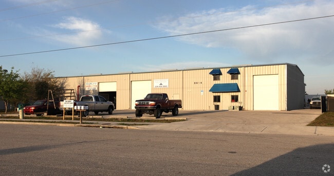
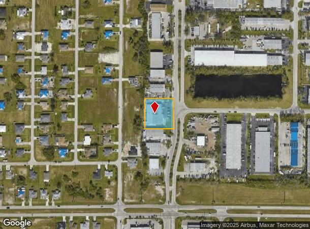
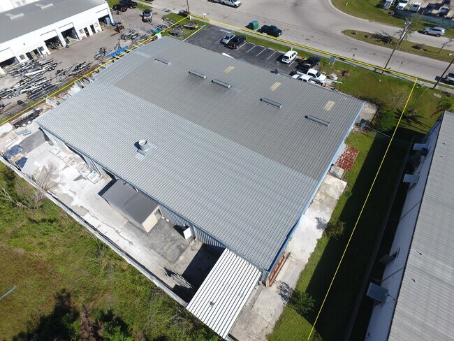
2414 Andalusia Blvd, Cape Coral, FL 33909
NEARBY LISTINGS FOR SALE OR LEASE
Property Detail
2414 Andalusia Blvd
Cape Coral-Fort Myers, FL
Cape Coral
30-43-24-C4-00300.0040
CAPE CORAL LEE COUNTY INDUSTRIAL PK PB 34 PG 143 BLK 6900 LOTS 4 + 5
Lightindustrial
Lee
X
Florida
12071C0254G
4,5
2024
0.92 AC
2025
Cape Coral
010208
Southwest Florida
14,124 SF
DEMOGRAPHICS near 2414 Andalusia Blvd
1 Mile
3 Mile
5 Mile
2024 Total Population
6,075
44,694
122,706
2029 Population
7,231
53,526
146,063
Pop Growth 2024-2029
+ 19.03%
+ 19.76%
+ 19.03%
Average Age
37
39
44
2024 Total Households
1,987
15,645
47,726
HH Growth 2024-2029
+ 18.52%
+ 19.23%
+ 18.45%
Median Household Inc
$72,509
$67,503
$61,045
Avg Household Size
2.90
2.80
2.50
2024 Avg HH Vehicles
2.00
2.00
2.00
Median Home Value
$242,167
$241,589
$222,206
Median Year Built
2004
2004
1998
Nearby Places
Map Layers
Map Styles
 Street
 Aerial
- Restaurants
- Banks
- Shops
- Fitness
- Groceries
PUBLIC TRANSPORTATION
AIRPORT
Punta Gorda
DRIVE
WALK
Distance
Punta Gorda
31 min
21.2 mi
Southwest Florida International
DRIVE
WALK
Distance
Southwest Florida International
37 min
22.0 mi
Freight Ports
Port Manatee
DRIVE
WALK
Distance
Port Manatee
111 min
92.9 mi
SALE & LEASE HISTORY
LISTING DATE
SALE/LEASE

Oct 31, 2022
For Sale
Nov 26, 2024
For Lease
Mar 17, 2020
For Sale
Aug 08, 2019
For Sale
Nearby Properties
Address
Land Use
TOTAL SIZE
Lot Size
Zoning
Address
Land Use
TOTAL SIZE
Lot Size
Zoning
214,515 SF
30.60 AC
I-1
Address
Land Use
TOTAL SIZE
Lot Size
Zoning
485,271 SF
20.05 AC
CORR
Address
Land Use
TOTAL SIZE
Lot Size
Zoning
262,258 SF
52.71 AC
INS
Address
Land Use
TOTAL SIZE
Lot Size
Zoning
61,844 SF
7.31 AC
CC
Address
Land Use
TOTAL SIZE
Lot Size
Zoning
138,476 SF
4.11 AC
CORR
Address
Land Use
TOTAL SIZE
Lot Size
Zoning
124,182 SF
13.30 AC
CORR
Address
Land Use
TOTAL SIZE
Lot Size
Zoning
71,898 SF
98.60 AC
C1-D
Address
Land Use
TOTAL SIZE
Lot Size
Zoning
76,042 SF
7.50 AC
CORR
Address
Land Use
TOTAL SIZE
Lot Size
Zoning
82,478 SF
15.46 AC
CORR
Address
Land Use
TOTAL SIZE
Lot Size
Zoning
212,616 SF
6.61 AC
CORR/CPO
Address
Land Use
TOTAL SIZE
Lot Size
Zoning
112,356 SF
18.99 AC
AG-2
Address
Land Use
TOTAL SIZE
Lot Size
Zoning
92,632 SF
32 AC
R1BD
Address
Land Use
TOTAL SIZE
Lot Size
Zoning
39,204 SF
5.89 AC
CORR
Address
Land Use
TOTAL SIZE
Lot Size
Zoning
197,353 SF
14 AC
VILL
Address
Land Use
TOTAL SIZE
Lot Size
Zoning
228.33 AC
R1A
Address
Land Use
TOTAL SIZE
Lot Size
Zoning
58,339 SF
3.55 AC
VILL
Address
Land Use
TOTAL SIZE
Lot Size
Zoning
81,845 SF
5.53 AC
CORR
Address
Land Use
TOTAL SIZE
Lot Size
Zoning
79,253 SF
11.47 AC
C-3
Address
Land Use
TOTAL SIZE
Lot Size
Zoning
19,218 SF
3.79 AC
CC
Address
Land Use
TOTAL SIZE
Lot Size
Zoning
48,780 SF
14.99 AC
Address
Land Use
TOTAL SIZE
Lot Size
Zoning
53,781 SF
6.84 AC
CPO
Address
Land Use
TOTAL SIZE
Lot Size
Zoning
51,732 SF
6.10 AC
CORR
Address
Land Use
TOTAL SIZE
Lot Size
Zoning
84,278 SF
5 AC
CORR
Address
Land Use
TOTAL SIZE
Lot Size
Zoning
196,060 SF
17.51 AC
CORR
Address
Land Use
TOTAL SIZE
Lot Size
Zoning
77,488 SF
3.19 AC
C-1
Address
Land Use
TOTAL SIZE
Lot Size
Zoning
227,503 SF
11.31 AC
CORR
Address
Land Use
TOTAL SIZE
Lot Size
Zoning
26,779 SF
2.25 AC
VILL
Address
Land Use
TOTAL SIZE
Lot Size
Zoning
26,800 SF
3.80 AC
CPO
Address
Land Use
TOTAL SIZE
Lot Size
Zoning
96,905 SF
14.16 AC
CORR
Address
Land Use
TOTAL SIZE
Lot Size
Zoning
134,519 SF
12.31 AC
C-3
The World's #1 Commercial Real Estate Marketplace
Connect with us
© 2025 CoStar Group
The information above has been obtained from sources believed reliable. While we do not doubt its accuracy we have not verified it and make no guarantee, warranty or representation about it. It is your responsibility to independently confirm its accuracy and completeness. Any projections, opinions, assumptions, or estimates used are for example only and do not represent the current or future performance of the property. The value of this transaction to you depends on tax and other factors which should be evaluated by your tax, financial, and legal advisors. You and your advisors should conduct a careful, independent investigation of the property to determine to your satisfaction the suitability of the property for your needs.