Property Record
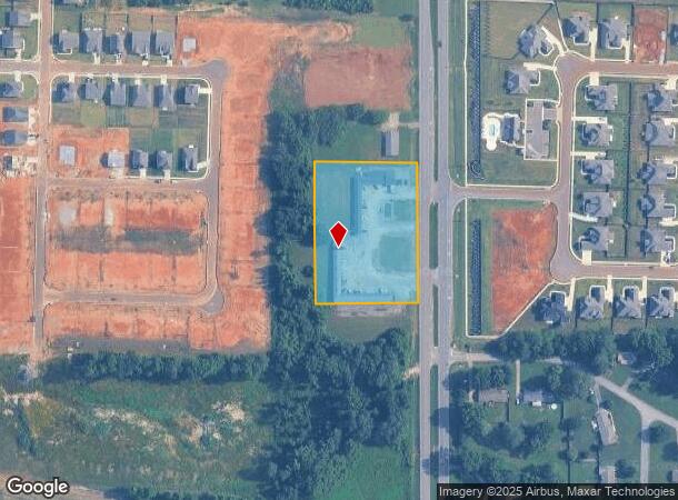
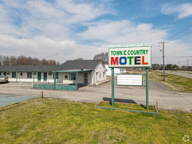
2414 Highway 31 S, Athens, AL 35611

NEARBY LISTINGS FOR SALE OR LEASE
-
-
View all Athens listings for sale on LoopNet.com
Property Detail
2414 Highway 31 S
10-08-28-0-000-011.000
COM NE COR OF NW/4 TH S 1111W 40 TO POB CONT W 300 S 400E 300 N 400 TO
Motel
Limestone
X
Alabama
01083C0189F
2.75 AC
2025
Huntsville
2024
Huntsville
020402
Huntsville, AL
5,048 SF
DEMOGRAPHICS near 2414 Highway 31 S
1 Mile
3 Mile
5 Mile
2024 Total Population
675
11,429
35,146
2029 Population
797
13,447
41,477
Pop Growth 2024-2029
+ 18.07%
+ 17.66%
+ 18.01%
Average Age
41
42
42
2024 Total Households
262
4,692
14,246
HH Growth 2024-2029
+ 18.32%
+ 18.12%
+ 18.48%
Median Household Inc
$75,510
$64,228
$56,678
Avg Household Size
2.50
2.40
2.40
2024 Avg HH Vehicles
2.00
2.00
2.00
Median Home Value
$254,687
$259,636
$227,702
Median Year Built
1986
1987
1987
Nearby Places
Map Layers
Map Styles
 Street
 Aerial
- Restaurants
- Banks
- Shops
- Fitness
- Groceries
PUBLIC TRANSPORTATION
AIRPORT
Huntsville International-Carl T Jones Field
DRIVE
WALK
Distance
Huntsville International-Carl T Jones Field
28 min
21.0 mi
Freight Ports
Port of Mobile
DRIVE
WALK
Distance
Port of Mobile
377 min
345.8 mi
SALE & LEASE HISTORY
LISTING DATE
SALE/LEASE

Sep 23, 2016
For Sale
Apr 11, 2018
For Sale
Nearby Properties
Address
Land Use
TOTAL SIZE
Lot Size
Zoning
Address
Land Use
TOTAL SIZE
Lot Size
Zoning
395,826 SF
42 AC
Address
Land Use
TOTAL SIZE
Lot Size
Zoning
45,536 SF
13.96 AC
Address
Land Use
TOTAL SIZE
Lot Size
Zoning
4,800 SF
32 AC
Address
Land Use
TOTAL SIZE
Lot Size
Zoning
55,196 SF
21.21 AC
Address
Land Use
TOTAL SIZE
Lot Size
Zoning
2,119 SF
17.54 AC
Address
Land Use
TOTAL SIZE
Lot Size
Zoning
6,703 SF
54.94 AC
Address
Land Use
TOTAL SIZE
Lot Size
Zoning
194,291 SF
21.53 AC
Address
Land Use
TOTAL SIZE
Lot Size
Zoning
134,312 SF
17.38 AC
Address
Land Use
TOTAL SIZE
Lot Size
Zoning
117,586 SF
34.35 AC
Address
Land Use
TOTAL SIZE
Lot Size
Zoning
42,868 SF
11.54 AC
Address
Land Use
TOTAL SIZE
Lot Size
Zoning
36,460 SF
6.65 AC
Address
Land Use
TOTAL SIZE
Lot Size
Zoning
36,990 SF
7.72 AC
Address
Land Use
TOTAL SIZE
Lot Size
Zoning
60,612 SF
3.74 AC
Address
Land Use
TOTAL SIZE
Lot Size
Zoning
6,310 SF
13.68 AC
Address
Land Use
TOTAL SIZE
Lot Size
Zoning
780 SF
11.87 AC
Address
Land Use
TOTAL SIZE
Lot Size
Zoning
241,870 SF
7.50 AC
Address
Land Use
TOTAL SIZE
Lot Size
Zoning
45,156 SF
2.28 AC
Address
Land Use
TOTAL SIZE
Lot Size
Zoning
Address
Land Use
TOTAL SIZE
Lot Size
Zoning
15,720 SF
10.21 AC
Address
Land Use
TOTAL SIZE
Lot Size
Zoning
17 AC
Address
Land Use
TOTAL SIZE
Lot Size
Zoning
11,928 SF
1.88 AC
Address
Land Use
TOTAL SIZE
Lot Size
Zoning
Address
Land Use
TOTAL SIZE
Lot Size
Zoning
42,975 SF
2.18 AC
Address
Land Use
TOTAL SIZE
Lot Size
Zoning
9,992 SF
10.58 AC
Address
Land Use
TOTAL SIZE
Lot Size
Zoning
5,000 SF
10.30 AC
Address
Land Use
TOTAL SIZE
Lot Size
Zoning
4.33 AC
Address
Land Use
TOTAL SIZE
Lot Size
Zoning
30,000 SF
4.87 AC
Address
Land Use
TOTAL SIZE
Lot Size
Zoning
27,632 SF
20.73 AC
Address
Land Use
TOTAL SIZE
Lot Size
Zoning
10,080 SF
6.50 AC
Address
Land Use
TOTAL SIZE
Lot Size
Zoning
12,881 SF
1.63 AC
The World's #1 Commercial Real Estate Marketplace
Connect with us
© 2025 CoStar Group
The information above has been obtained from sources believed reliable. While we do not doubt its accuracy we have not verified it and make no guarantee, warranty or representation about it. It is your responsibility to independently confirm its accuracy and completeness. Any projections, opinions, assumptions, or estimates used are for example only and do not represent the current or future performance of the property. The value of this transaction to you depends on tax and other factors which should be evaluated by your tax, financial, and legal advisors. You and your advisors should conduct a careful, independent investigation of the property to determine to your satisfaction the suitability of the property for your needs.