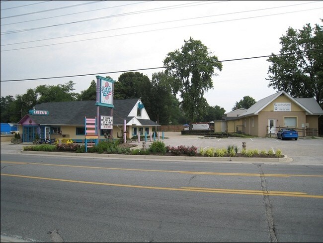
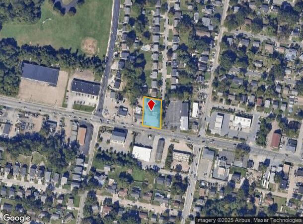
Property Record
2414 Mountain Rd, Pasadena, MD 21122

NEARBY LISTINGS FOR SALE OR LEASE
Property Detail
2414 Mountain Rd
Baltimore-Columbia-Towson, MD
Green Haven
03-388-06075010
LTS 4 5 GREEN HAVEN
Commercialacreage
Anne Arundel
X
Maryland
24003C0068F
4
2024
0.44 AC
2025
Route 2 Corridor North
731312
Baltimore
1,727 SF
DEMOGRAPHICS near 2414 Mountain Rd
1 Mile
3 Mile
5 Mile
2024 Total Population
13,136
70,747
174,198
2029 Population
13,402
72,456
178,267
Pop Growth 2024-2029
+ 2.02%
+ 2.42%
+ 2.34%
Average Age
39
39
40
2024 Total Households
4,538
25,972
64,158
HH Growth 2024-2029
+ 2.05%
+ 2.48%
+ 2.38%
Median Household Inc
$108,052
$109,502
$107,079
Avg Household Size
2.80
2.70
2.70
2024 Avg HH Vehicles
2.00
2.00
2.00
Median Home Value
$359,509
$383,530
$397,379
Median Year Built
1984
1984
1979
Nearby Places
Map Layers
Map Styles
 Street
 Aerial
- Restaurants
- Banks
- Shops
- Fitness
- Groceries
PUBLIC TRANSPORTATION
AIRPORT
Baltimore/Washington International Thurgood Marshall
DRIVE
WALK
Distance
Baltimore/Washington International Thurgood Marshall
21 min
12.0 mi
Freight Ports
Port of Baltimore
DRIVE
WALK
Distance
Port of Baltimore
28 min
13.6 mi
SALE & LEASE HISTORY
LISTING DATE
SALE/LEASE

Sep 30, 2022
For Lease
Sep 18, 2023
For Lease
Nearby Properties
Address
Land Use
TOTAL SIZE
Lot Size
Zoning
Address
Land Use
TOTAL SIZE
Lot Size
Zoning
374,664 SF
22.89 AC
R15
Address
Land Use
TOTAL SIZE
Lot Size
Zoning
32.18 AC
R15
Address
Land Use
TOTAL SIZE
Lot Size
Zoning
176,405 SF
41.81 AC
C3
Address
Land Use
TOTAL SIZE
Lot Size
Zoning
285,360 SF
14.96 AC
Address
Land Use
TOTAL SIZE
Lot Size
Zoning
16.72 AC
R15
Address
Land Use
TOTAL SIZE
Lot Size
Zoning
7.07 AC
R15
Address
Land Use
TOTAL SIZE
Lot Size
Zoning
154,044 SF
16.89 AC
C3
Address
Land Use
TOTAL SIZE
Lot Size
Zoning
123,376 SF
25.42 AC
C3
Address
Land Use
TOTAL SIZE
Lot Size
Zoning
340,000 SF
35 AC
W1
Address
Land Use
TOTAL SIZE
Lot Size
Zoning
238,688 SF
35 AC
R5
Address
Land Use
TOTAL SIZE
Lot Size
Zoning
166,646 SF
4.61 AC
R22
Address
Land Use
TOTAL SIZE
Lot Size
Zoning
303,626 SF
20.88 AC
C3
Address
Land Use
TOTAL SIZE
Lot Size
Zoning
345,088 SF
28.26 AC
W2
Address
Land Use
TOTAL SIZE
Lot Size
Zoning
106,160 SF
5.11 AC
R-2
Address
Land Use
TOTAL SIZE
Lot Size
Zoning
106,760 SF
5.09 AC
C4
Address
Land Use
TOTAL SIZE
Lot Size
Zoning
122,175 SF
7.32 AC
R5
Address
Land Use
TOTAL SIZE
Lot Size
Zoning
209,143 SF
19.29 AC
C3
Address
Land Use
TOTAL SIZE
Lot Size
Zoning
79,311 SF
3.90 AC
C2
Address
Land Use
TOTAL SIZE
Lot Size
Zoning
191,856 SF
5.61 AC
R15
Address
Land Use
TOTAL SIZE
Lot Size
Zoning
80,512 SF
4.87 AC
R22
Address
Land Use
TOTAL SIZE
Lot Size
Zoning
141,829 SF
29.38 AC
R5
Address
Land Use
TOTAL SIZE
Lot Size
Zoning
121,846 SF
8.10 AC
C4
Address
Land Use
TOTAL SIZE
Lot Size
Zoning
9.97 AC
R15
Address
Land Use
TOTAL SIZE
Lot Size
Zoning
45,570 SF
3.46 AC
C4
Address
Land Use
TOTAL SIZE
Lot Size
Zoning
99,218 SF
2.96 AC
R22
Address
Land Use
TOTAL SIZE
Lot Size
Zoning
90,488 SF
9.82 AC
C3
Address
Land Use
TOTAL SIZE
Lot Size
Zoning
195,528 SF
5.36 AC
R22
Address
Land Use
TOTAL SIZE
Lot Size
Zoning
10.90 AC
R15
Address
Land Use
TOTAL SIZE
Lot Size
Zoning
70,288 SF
17.86 AC
R5
Address
Land Use
TOTAL SIZE
Lot Size
Zoning
125.29 AC
W1
The World's #1 Commercial Real Estate Marketplace
Connect with us
© 2025 CoStar Group
The information above has been obtained from sources believed reliable. While we do not doubt its accuracy we have not verified it and make no guarantee, warranty or representation about it. It is your responsibility to independently confirm its accuracy and completeness. Any projections, opinions, assumptions, or estimates used are for example only and do not represent the current or future performance of the property. The value of this transaction to you depends on tax and other factors which should be evaluated by your tax, financial, and legal advisors. You and your advisors should conduct a careful, independent investigation of the property to determine to your satisfaction the suitability of the property for your needs.