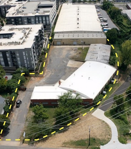
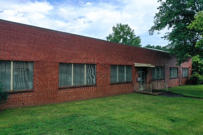
Property Record
N Brevard St, Charlotte, NC
Current Lease Availabilities
NEARBY LISTINGS FOR SALE OR LEASE
Property Detail
N Brevard St
Charlotte-Concord-Gastonia, NC-SC
P6&7 B8 M230-1
083-051-06
Mecklenburg
Commercialnec
North Carolina
AE
6
3710455400K
0.08 AC
2024
Sugar Creek
2025
Charlotte
005200
DEMOGRAPHICS near N Brevard St
1 Mile
3 Mile
5 Mile
2024 Total Population
14,077
120,470
290,324
2029 Population
15,501
129,092
309,662
Pop Growth 2024-2029
+ 10.12%
+ 7.16%
+ 6.66%
Average Age
35
36
36
2024 Total Households
7,006
58,814
127,964
HH Growth 2024-2029
+ 10.26%
+ 7.35%
+ 6.83%
Median Household Inc
$66,154
$67,345
$63,234
Avg Household Size
1.90
1.90
2.20
2024 Avg HH Vehicles
1.00
1.00
2.00
Median Home Value
$453,225
$380,476
$337,903
Median Year Built
2006
1997
1989
Nearby Places
- Restaurants
- Banks
- Shops
- Fitness
- Groceries
PUBLIC TRANSPORTATION
TRANSIT/SUBWAY
25Th St Station (Light Rail - Lynx Blue Line - CATS)
DRIVE
WALK
Distance
25Th St Station (Light Rail - Lynx Blue Line - CATS)
0 min
3 min
0.1 mi
Parkwood Station (Light Rail - Lynx Blue Line - CATS)
DRIVE
WALK
Distance
Parkwood Station (Light Rail - Lynx Blue Line - CATS)
2 min
12 min
0.6 mi
36Th St Station (Light Rail - Lynx Blue Line - CATS)
DRIVE
WALK
Distance
36Th St Station (Light Rail - Lynx Blue Line - CATS)
3 min
18 min
0.9 mi
COMMUTER RAIL
Charlotte Amtrak Station (Carolinian - Amtrak, Crescent - Amtrak, Piedmont - Amtrak)
DRIVE
WALK
Distance
Charlotte Amtrak Station (Carolinian - Amtrak, Crescent - Amtrak, Piedmont - Amtrak)
5 min
1.7 mi
AIRPORT
Charlotte/Douglas International
DRIVE
WALK
Distance
Charlotte/Douglas International
20 min
9.9 mi
Concord-Padgett Regional
DRIVE
WALK
Distance
Concord-Padgett Regional
23 min
13.7 mi
Freight Ports
North Charleston Terminal
DRIVE
WALK
Distance
North Charleston Terminal
233 min
202.7 mi
Nearby Properties
Address
Land Use
TOTAL SIZE
Lot Size
Zoning
Address
Land Use
TOTAL SIZE
Lot Size
Zoning
1,652,470 SF
10.96 AC
UMUD
Address
Land Use
TOTAL SIZE
Lot Size
Zoning
780,000 SF
7.69 AC
UMUD-O
Address
Land Use
TOTAL SIZE
Lot Size
Zoning
1,097,257 SF
2.34 AC
UMUD-O
Address
Land Use
TOTAL SIZE
Lot Size
Zoning
1,498,190 SF
2.09 AC
UMUD
Address
Land Use
TOTAL SIZE
Lot Size
Zoning
955,273 SF
1.83 AC
Address
Land Use
TOTAL SIZE
Lot Size
Zoning
1,483,634 SF
1.49 AC
Address
Land Use
TOTAL SIZE
Lot Size
Zoning
1,250,218 SF
17.75 AC
O2
Address
Land Use
TOTAL SIZE
Lot Size
Zoning
1,097,857 SF
2.40 AC
UMUDO
Address
Land Use
TOTAL SIZE
Lot Size
Zoning
1,052,203 SF
2.17 AC
Address
Land Use
TOTAL SIZE
Lot Size
Zoning
1,752,744 SF
3.20 AC
UMUDO
Address
Land Use
TOTAL SIZE
Lot Size
Zoning
1,266,700 SF
2.98 AC
Address
Land Use
TOTAL SIZE
Lot Size
Zoning
852,355 SF
16.72 AC
MUDDO
Address
Land Use
TOTAL SIZE
Lot Size
Zoning
1,325,933 SF
34.09 AC
Address
Land Use
TOTAL SIZE
Lot Size
Zoning
925,808 SF
1.84 AC
UMUD-O
Address
Land Use
TOTAL SIZE
Lot Size
Zoning
1,435,616 SF
33.78 AC
UMUD
Address
Land Use
TOTAL SIZE
Lot Size
Zoning
1,250,926 SF
4.89 AC
I2
Address
Land Use
TOTAL SIZE
Lot Size
Zoning
1,053,936 SF
2.47 AC
UMUD
Address
Land Use
TOTAL SIZE
Lot Size
Zoning
865,160 SF
2.80 AC
UMUD
Address
Land Use
TOTAL SIZE
Lot Size
Zoning
839,976 SF
1.62 AC
UMUD
Address
Land Use
TOTAL SIZE
Lot Size
Zoning
1,017,564 SF
13.91 AC
O2
Address
Land Use
TOTAL SIZE
Lot Size
Zoning
894,108 SF
4.52 AC
UMUDO
Address
Land Use
TOTAL SIZE
Lot Size
Zoning
696,527 SF
1.96 AC
UMUDO
Address
Land Use
TOTAL SIZE
Lot Size
Zoning
1,025,674 SF
3.43 AC
UMUD
Address
Land Use
TOTAL SIZE
Lot Size
Zoning
916,725 SF
2.35 AC
UMUD
Address
Land Use
TOTAL SIZE
Lot Size
Zoning
626,053 SF
2.77 AC
I2
Address
Land Use
TOTAL SIZE
Lot Size
Zoning
944,863 SF
3.58 AC
UMUD
Address
Land Use
TOTAL SIZE
Lot Size
Zoning
416,225 SF
0.64 AC
Address
Land Use
TOTAL SIZE
Lot Size
Zoning
1,039,198 SF
5.62 AC
UMUD
Address
Land Use
TOTAL SIZE
Lot Size
Zoning
864,694 SF
11.07 AC
MUDDO
Address
Land Use
TOTAL SIZE
Lot Size
Zoning
645,212 SF
3.76 AC
UMUD
The World's #1 Commercial Real Estate Marketplace
Connect with us
© 2025 CoStar Group
The information above has been obtained from sources believed reliable. While we do not doubt its accuracy we have not verified it and make no guarantee, warranty or representation about it. It is your responsibility to independently confirm its accuracy and completeness. Any projections, opinions, assumptions, or estimates used are for example only and do not represent the current or future performance of the property. The value of this transaction to you depends on tax and other factors which should be evaluated by your tax, financial, and legal advisors. You and your advisors should conduct a careful, independent investigation of the property to determine to your satisfaction the suitability of the property for your needs.