Property Record
2415 Augustine Rd, Neenah, WI 54956
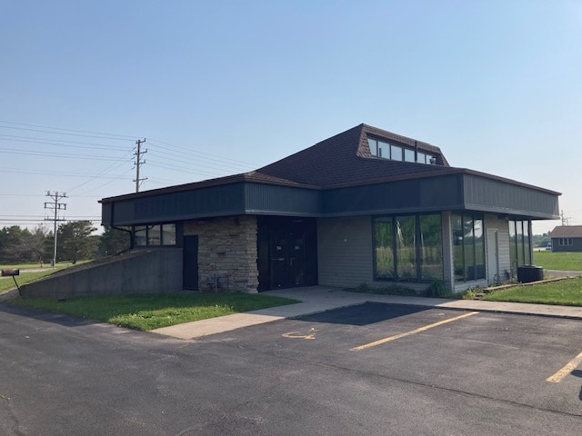

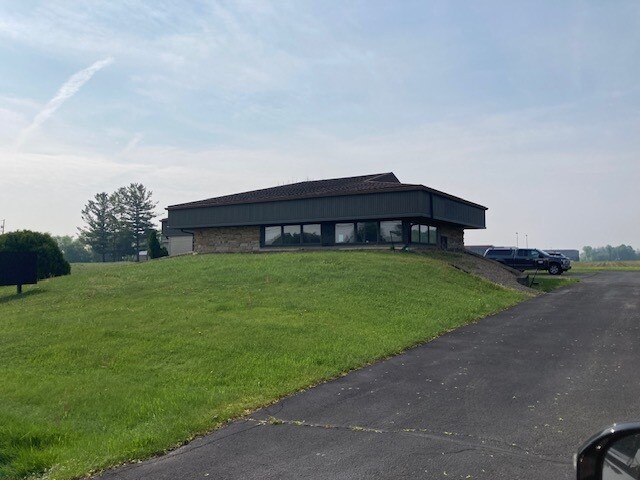
This Property Is For Sale
Property Detail
2415 Augustine Rd
Oshkosh-Neenah, WI
PT NW NW DESC AS LOT 1 OF CSM-958 EXC N 66 FT 2.27 A.
010-0188-01
WINNEBAGO
Commercialnec
Wisconsin
B2
1
B and X Area of moderate flood hazard, usually the area between the limits of the 100-year and 500-year floods.
2.27 AC
2024
Appleton/Oshkosh
2024
Other Market Areas
003703
NEARBY LISTINGS FOR SALE OR LEASE
DEMOGRAPHICS near 2415 Augustine Rd
1 mile
3 mile
5 mile
2025 Total Population
1,668
23,163
65,692
2030 Population
1,692
23,470
66,430
Pop Growth 2025-2030
+ 1.44%
+ 1.33%
+ 1.12%
Average Age
40
40
41
2025 Total Households
691
9,666
27,740
HH Growth 2025-2030
+ 1.45%
+ 1.25%
+ 1.07%
Median Household Inc
$84,291
$79,842
$76,073
Avg Household Size
2.40
2.30
2.30
2025 Avg HH Vehicles
2.00
2.00
2.00
Median Home Value
$251,269
$239,977
$235,860
Median Year Built
1976
1978
1974
Nearby Places
Map Layers
Map Styles
 Street
 Aerial
Transit
 Traffic
 Biking
Places
Listings with unknown addresses are not visible on the map
- Restaurants
- Banks
- Shops
- Fitness
- Groceries
PUBLIC TRANSPORTATION
AIRPORT
Appleton International
Drive
Walk
Distance
Appleton International
12 min
6.1 mi
Green Bay/Austin Straubel International
Drive
Walk
Distance
Green Bay/Austin Straubel International
46 min
36.4 mi
Freight Ports
Port Milwaukee
Drive
Walk
Distance
Port Milwaukee
121 min
103.5 mi
Nearby Properties
Address
Land Use
TOTAL SIZE
Lot Size
Zoning
Address
Land Use
TOTAL SIZE
Lot Size
Zoning
68.77 AC
Address
Land Use
TOTAL SIZE
Lot Size
Zoning
156.36 AC
M1
Address
Land Use
TOTAL SIZE
Lot Size
Zoning
11.99 AC
Address
Land Use
TOTAL SIZE
Lot Size
Zoning
120.73 AC
M2
Address
Land Use
TOTAL SIZE
Lot Size
Zoning
11.22 AC
Address
Land Use
TOTAL SIZE
Lot Size
Zoning
1,975 SF
2.40 AC
M2
Address
Land Use
TOTAL SIZE
Lot Size
Zoning
9.40 AC
Address
Land Use
TOTAL SIZE
Lot Size
Zoning
59,584 SF
12.11 AC
C1
Address
Land Use
TOTAL SIZE
Lot Size
Zoning
103,427 SF
0.56 AC
PDD
Address
Land Use
TOTAL SIZE
Lot Size
Zoning
6.75 AC
M1
Address
Land Use
TOTAL SIZE
Lot Size
Zoning
10.42 AC
Address
Land Use
TOTAL SIZE
Lot Size
Zoning
89,576 SF
1.03 AC
C2
Address
Land Use
TOTAL SIZE
Lot Size
Zoning
105,852 SF
0.39 AC
PDD
Address
Land Use
TOTAL SIZE
Lot Size
Zoning
15.73 AC
B5
Address
Land Use
TOTAL SIZE
Lot Size
Zoning
210,214 SF
16.44 AC
I1
Address
Land Use
TOTAL SIZE
Lot Size
Zoning
86,455 SF
PDD
Address
Land Use
TOTAL SIZE
Lot Size
Zoning
17.55 AC
A2
Address
Land Use
TOTAL SIZE
Lot Size
Zoning
4.33 AC
Address
Land Use
TOTAL SIZE
Lot Size
Zoning
74,603 SF
4.96 AC
I1
Address
Land Use
TOTAL SIZE
Lot Size
Zoning
7.29 AC
Address
Land Use
TOTAL SIZE
Lot Size
Zoning
92,030 SF
7.79 AC
I1
Address
Land Use
TOTAL SIZE
Lot Size
Zoning
10.13 AC
M2
Address
Land Use
TOTAL SIZE
Lot Size
Zoning
11.77 AC
R5
Address
Land Use
TOTAL SIZE
Lot Size
Zoning
32.60 AC
Address
Land Use
TOTAL SIZE
Lot Size
Zoning
31,400 SF
0.37 AC
PDD
Address
Land Use
TOTAL SIZE
Lot Size
Zoning
48,933 SF
2.80 AC
PDD
Address
Land Use
TOTAL SIZE
Lot Size
Zoning
4.71 AC
Address
Land Use
TOTAL SIZE
Lot Size
Zoning
4.38 AC
B5
Address
Land Use
TOTAL SIZE
Lot Size
Zoning
4.41 AC
B5
Address
Land Use
TOTAL SIZE
Lot Size
Zoning
28.64 AC
The World's #1 Commercial Real Estate Marketplace
Connect with us
© 2026 CoStar Group
The information above has been obtained from sources believed reliable. While we do not doubt its accuracy we have not verified it and make no guarantee, warranty or representation about it. It is your responsibility to independently confirm its accuracy and completeness. Any projections, opinions, assumptions, or estimates used are for example only and do not represent the current or future performance of the property. The value of this transaction to you depends on tax and other factors which should be evaluated by your tax, financial, and legal advisors. You and your advisors should conduct a careful, independent investigation of the property to determine to your satisfaction the suitability of the property for your needs.